Callao
Callao (/kɑːˈjɑːoʊ/; [kaˈʎa.o, -ˈʝa-]) is a seaside city on the Pacific Ocean in the Lima metropolitan area. Callao is Peru's chief seaport and home to its main airport, Jorge Chávez International Airport. Callao municipality consists of the whole Callao Region, which is also coterminous with the Province of Callao. Founded in 1537 by the Spanish, the city has a long naval history as one of the main ports in Latin America and the Pacific, as it was one of vital Spanish towns during the colonial era. Central Callao is about 15 km (9.3 mi) west of the Historic Centre of Lima.
Callao | |
|---|---|
City | |
 Photo montage of Callao | |
 Flag | |
| Nicknames: La Perla del Pacífico (Pearl of the Pacific)[1] El Primer Puerto (The First Harbor) | |
| Motto(s): La fiel y generosa ciudad del Callao, asilo de las leyes y de la libertad. (The faithful and generous city of Callao, asylum of the laws and freedom.) | |
 Callao Location within Peru | |
| Coordinates: 12°2′S 77°8′W | |
| Country | |
| Region | Callao |
| Provinces | Constitutional Province of Callao |
| Founded | 6 March 1537 |
| Founded by | Diego Ruiz[2] |
| Districts | 7 Districts
|
| Government | |
| • Governor | Dante Mandriotti (2019–2022) |
| • Mayor | Pedro López Barrios |
| Area | |
| • Total | 147.85 km2 (57.09 sq mi) |
| Elevation | 5 m (16 ft) |
| Population (2017)[3] | |
| • Total | 994,494 |
| • Density | 6,700/km2 (17,000/sq mi) |
| Demonym(s) | Chalaco/a |
| Time zone | UTC-5 (PET) |
| Postal code | 07001 |
| Area code(s) | 14 |
| Website | Official Website |

History


El Callao was founded by Spanish colonists in 1537, just two years after Lima (1535). It soon became the main port for Spanish commerce in the Pacific. The origin of its name is unknown; both Indian (particularly Yunga, or Coastal Peruvian) and Spanish sources are credited, but it is certain that it was known by that name since 1550. Other sources point to the similarity with the Portuguese word calhau [pebble], having a similar sound.
At the height of the Viceroyalty, virtually all goods produced in Peru, Bolivia, and Argentina were carried over the Andes by mule to Callao, to be shipped to Panama, carried overland, and then transported on to Spain via Cuba.
After the Battle of Ayacucho, 9 December 1824, that sealed the independence of Peru and South America, Spain made futile attempts to retain its former colonies, such as at the Siege of Callao (1826). On 20 August 1836, during the Peru-Bolivian Confederacy, President Andrés de Santa Cruz mandated the creation of the Callao Littoral Province (Provincia Litoral del Callao), which had political autonomy in its internal affairs. During the government of President Ramón Castilla, Callao was given the name of Constitutional Province (Provincia Constitucional), on 22 April 1857; before that, Callao had the name of Littoral Province. All of the other Peruvian provinces had been given their names by law, while Callao was given it by constitutional mandate.
Callao was never part of the Lima Department nor of any other departments.
The province's first mayor was Col. Manuel Cipriano Dulanto.
By 1949, Callao was known as one of the biggest centers of coca-based products and cocaine traffic in the world.[4]
Notable events
- On 28 October 1746, a tsunami caused by the 1746 Lima–Callao earthquake destroyed the entire port of Callao.
- On 22 January 1826, besieged by nationalist forces backed by Simón Bolívar, General José Ramón Rodil surrendered Callao to General Bartolomé Salom.
- On 2 May 1866, during the Battle of Callao, the Spanish fleet tried to reconquer independent Peru.
- Kon-Tiki left Callao, Peru, on the afternoon of 28 April 1947.
- On 19 June 1986, dozens of Sendero Luminoso terrorists tried to escape but encountered the government's naval forces on El Frontón, resulting in the so-called Peruvian prison massacres.
City highlights
Callao is built on and around a peninsula, the district of La Punta, a wealthy residential neighborhood. A historical fortress, the Castillo de Real Felipe (site of "Rodil's Last Stand"), stands on the promontory overlooking the harbor.
A large naval base is sited in Callao. Its prison holds Abimael Guzmán, the leader of the Shining Path Communist Party of Peru, and Vladimiro Montesinos, the ex-director of internal security during the Fujimori regime.
Jorge Chávez International Airport is located in Callao.
On a bluff overlooking the harbor sits Colegio Militar Leoncio Prado, the military high school. The city also has a university, the National University of Callao.
The main Naval Hospital, Centro Medico Naval is located on Avenida Venezuela in Bellavista. It contains the U.S. Navy command Naval Medical Research Unit Six.
Residents of Callao are known as chalacos.
Callao's professional football teams are Sport Boys and Atlético Chalaco.
Islands
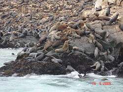
Callao has several islands: San Lorenzo (currently a military base), El Frontón (a former high security prison), the Cavinzas Islands, and the Palomino Islands, where numerous sea lions and sea birds live in a virtually untouched ecosystem. There are proposed plans to build a huge naval, terrestrial, and air port on San Lorenzo Island. This project is called the San Lorenzo Megaport Project.
Government
Local government affairs are divided into two levels. Regional matters are handled by the Regional Government of Callao (Gobierno Regional del Callao), which is located in the Bellavista District. Affairs such as city cleaning, promoting of sports and basic services are handled by the Provincial Municipality of Callao, which is headquartered in the Callao District. Also, each of the six districts has its own Municipality which handles matters in their respective jurisdictional areas.
Administrative divisions
Callao is divided into seven districts, (Spanish: distritos; singular: distrito), each of which is headed by a mayor (alcalde).
| Districts of Callao[5] | ||||||||
|---|---|---|---|---|---|---|---|---|
| Map N° | District | Population | Area km² | Density (pers/km²) | Map of the districts of Callao | Map | ||
| 1 | Callao (downtown) | 415,888 | 45.65 | 9,147.60 |  |  | ||
| 2 | Bellavista | 75,163 | 4.56 | 16 483.11 | ||||
| 3 | Carmen de la Legua Reynoso | 41,863 | 2.12 | 19,746.7 | ||||
| 4 | La Perla | 61,698 | 2.75 | 22,435.64 | ||||
| 5 | La Punta | 4,370 | 0.75 | 5,826.67 | ||||
| 6 | Ventanilla | 277,895 | 73.52 | 3,779.86 | ||||
| 7 | Mi Perú (part of Ventanilla until May 2014) | 51,522 | 2.47 | 20,859.11 | ||||
The rest of Callao Region is composed of the islands of San Lorenzo, El Frontón, Cavinzas and Palomino, which all together have an area of 17.63 square kilometres (6.81 sq mi).
Transportation
Airport
Jorge Chávez International Airport (IATA: LIM, ICAO: SPIM), known as Aeropuerto Internacional Jorge Chávez in Spanish, is Peru's main international and domestic airport. It is located in Callao, 12 km (7.5 mi) from the Historic Centre of Lima and 19 km (12 mi) from Miraflores. Callao is the port city now fully integrated with Lima, the nation's capital. In 2008, the airport handled 8,288,506 passengers and 98,733 aircraft movements.
For many years it was the hub for now defunct Aeroperú and Compañía de Aviación Faucett, one of the oldest airlines in Latin America. Now it serves as a hub for many aviation companies such as Avianca Perú, Viva Air Perú, and LATAM Perú.

Railway
The port is served by the Ferrocarril Central Andino railway, which from 2006 to 2010 was converted from 3 feet (914 mm) gauge to the world standard gauge of 4 ft 8 1⁄2 in (1,435 mm).
References
- Camara de Comercio de Lima, ed. (2000). "La Perla del Pacífico". Retrieved 9 May 2012.
- "Página en www.regioncallao.gob.pe". Archived from the original on 22 August 2014. Retrieved 14 August 2014.
- Population of Callao
- "The White Goddess", TIME Magazine, 11 April 1949
- Municipalidad provincial del Callao (2012). "El Callao – Distritos del Callao" (in Spanish). Archived from the original on 1 May 2015.
External links
| Wikimedia Commons has media related to Callao. |
| Wikivoyage has a travel guide for Callao. |
- Municipality of Callao (in Spanish)
- Regional government of Callao
- Jorge Chavez International Airport
- National University of Callao (in Spanish)
Places adjacent to Callao | |
|---|---|
Peru's Lima Province is not part of any region. |