Pachacamac District
The Pachacamac District is one of 43 districts of the Lima Province in Peru. The capital of the district is the village of Pachacamac. Its main asset is the archaeological Inca site Pachacamac.
Pachacamac | |
|---|---|
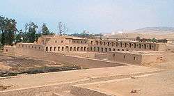 Pachacamac archaeological site | |
 Coat of arms | |
 Location of Pachacamac in the Lima province | |
| Country | |
| Region | Lima |
| Province | Lima |
| Founded | January 2, 1857 |
| Capital | Pachacamac |
| Subdivisions | 11 populated centers |
| Government | |
| • Mayor | Guillermo Elvis Pómez Cano (2019-2022) |
| Area | |
| • Total | 160.23 km2 (61.87 sq mi) |
| Elevation | 75 m (246 ft) |
| Population (2017) | |
| • Total | 110,071 |
| • Density | 690/km2 (1,800/sq mi) |
| Time zone | UTC-5 (PET) |
| UBIGEO | 150123 |
| Website | munipachacamac.gob.pe |
History
Pachacamac was first encountered by Hernándo Pizarro on January 30, 1530 while on his quest for gold and his search for a location of a new capital. In 1573 the city of Santísimo Salvador de Pachacámac was founded. In 1857, Pachacamac was founded as a republican district.[1]
Location
The district is located in the southern part of the Lima province at an elevation of 75m.
Political division
The district is divided into 11 populated centers (Spanish: Centros Poblados):
- Pachacamac
- Puente Manchay
- Tambo Inga
- Pampa Flores
- Manchay Alto Lote B
- Invasion Cementerio
- Manchay Bajo
- Santa Rosa de Mal Paso
- Cardal
- Jatosisa
- Tomina
Capital
The capital of the Pachacamac district is the village of Pachacamac.
References
- (in Spanish) Pachacamac Municipality, History, Retrieved October 31, 2007.
See also
External links
- (in Spanish) Official web site
This article is issued from Wikipedia. The text is licensed under Creative Commons - Attribution - Sharealike. Additional terms may apply for the media files.