Bradley County, Tennessee
Bradley County is a county located in the southeastern portion of the U.S. state of Tennessee. As of the 2010 census, the population was 98,963,[4] making it the thirteenth most populous county in Tennessee. Its county seat is Cleveland.[5] It is named for Colonel Edward Bradley of Shelby County, Tennessee, who was colonel of Hale's Regiment in the American Revolution and the 15th Regiment of the Tennessee Volunteers in the War of 1812.[2]
Bradley County | |
|---|---|
 The Bradley County courthouse in Cleveland | |
 Seal | |
| Motto(s): "Agriculture and Industry"[1] | |
 Location within the U.S. state of Tennessee | |
 Tennessee's location within the U.S. | |
| Coordinates: 35°09′N 84°52′W | |
| Country | |
| State | |
| Founded | May 2, 1836 |
| Named for | Edward Bradley, state legislator[2] |
| Seat | Cleveland |
| Largest city | Cleveland |
| Area | |
| • Total | 331 sq mi (860 km2) |
| • Land | 329 sq mi (850 km2) |
| • Water | 2.7 sq mi (7 km2) 0.8%% |
| Population | |
| • Estimate (2018) | 106,727 |
| • Density | 301/sq mi (116/km2) |
| Time zone | UTC−5 (Eastern) |
| • Summer (DST) | UTC−4 (EDT) |
| ZIP Codes | 37310, 37311, 37312, 37320, 37323, 37353, 37364[3] |
| Congressional districts | 3rd, 4th |
| Website | www |
Bradley County is included in the Cleveland, Tennessee Metropolitan Statistical Area, which is also included in the Chattanooga-Cleveland-Dalton, TN-GA-AL Combined Statistical Area.
History

Bradley County was likely first seen by Europeans on June 2, 1540 by Hernando De Soto and his expedition while traveling through the North American continent.[6] Until the early 19th century, the land that is now Bradley County was part of the Cherokee Nation.[7] A large region located in present-day Bradley County was called Chatata, meaning "clear water", by the Cherokees.[8] In anticipation of forced removal of the Cherokee, white settlers began to move rapidly into the area. In 1821, the Cherokee Agency, the official liaison between the U.S. Government and the Cherokee Nation, was moved to present day Charleston.[9] Between 1832 and 1838, the Red Clay Council Grounds on the southern border of Bradley County with Georgia served as the capitol and the last council grounds of the eastern band of the Cherokee Nation.[10] This is now a state park, Red Clay State Park. The Cherokee Removal began with the Treaty of New Echota, signed on December 29, 1835. General Winfield Scott was given the task of removing the Cherokee from the area, and set up the headquarters at Fort Cass in Charleston.[10] Several internment camps were established in Bradley County in the valleys between Charleston and Cleveland where the Cherokee were held in preparation for the journey westward, which became known as the Trail of Tears.[10] Two of the largest were located at Rattlesnake Springs.[11]
Bradley County was established on February 10, 1836. It was named to honor Colonel Edward Bradley who served in the War of 1812.[12] The first election in Bradley County took place on April 2, 1836.[7] On January 20, 1838, Cleveland, a township with a population of 400, became the seat of Bradley County.[13] Cleveland was incorporated on February 2, 1842.[13]
Like most East Tennessee counties, Bradley County was largely opposed to secession on the eve of the Civil War. In Tennessee's Ordinance of Secession referendum on June 8, 1861, the county's residents voted against secession by a margin of 1,382 to 507.[14] No major battles were fought in Bradley County, but several major skirmishes between Union and Confederate troops took place within the county, including a failed attempt by Confederate soldiers to destroy a Union train near the Tasso community that instead resulted in the destruction of a Confederate train.[15] The bridge over the Hiwassee River was burned on November 8, 1861, by members of the East Tennessee bridge-burning conspiracy led by Alfred Cate.[16] On November 4, 1862 a train accident south of Cleveland near the Black Fox community killed 17 members of the 33rd Regiment Alabama Infantry who were being transported to Chattanooga.[17] The city of Cleveland was occupied by the Confederate Army from 1861 to 1863.[18]
Geography
According to the U.S. Census Bureau, the county has a total area of 331 square miles (860 km2), of which 329 square miles (850 km2) is land and 2.7 square miles (7.0 km2) (0.8%) is water.[19] The county is situated on a series of paralleling ridges running north-northeasterly which are part of the Ridge and Valley Appalachians. The highest of these, Candies Creek Ridge, runs through the center of Cleveland. Located in between these ridges are creeks, and there are several springs in the county, which made the area favorable to early settlers. The highest point in the county is located on the Hamilton County line along White Oak Mountain. The majority of the county is located in the Tennessee Valley drainage basin, except for approximately the southeastern third, which is located in the Mobile River basin and contains the Conasauga River. The county is bordered on the north by the Hiwassee River.[20][21]
Adjacent counties
- Meigs County (northwest)
- McMinn County (north)
- Polk County (east)
- Murray County, Georgia (southeast)
- Whitfield County, Georgia (south)
- Hamilton County (west)
State protected areas
- Chickamauga Wildlife Management Area (part)
- Charlotte Anne Finnell Neal Wildlife Management Area
- Red Clay State Park
Demographics
| Historical population | |||
|---|---|---|---|
| Census | Pop. | %± | |
| 1840 | 7,385 | — | |
| 1850 | 12,259 | 66.0% | |
| 1860 | 11,701 | −4.6% | |
| 1870 | 11,652 | −0.4% | |
| 1880 | 12,124 | 4.1% | |
| 1890 | 13,607 | 12.2% | |
| 1900 | 15,759 | 15.8% | |
| 1910 | 16,336 | 3.7% | |
| 1920 | 18,652 | 14.2% | |
| 1930 | 22,870 | 22.6% | |
| 1940 | 28,498 | 24.6% | |
| 1950 | 32,338 | 13.5% | |
| 1960 | 38,324 | 18.5% | |
| 1970 | 50,686 | 32.3% | |
| 1980 | 67,547 | 33.3% | |
| 1990 | 73,712 | 9.1% | |
| 2000 | 87,965 | 19.3% | |
| 2010 | 98,963 | 12.5% | |
| Est. 2018 | 106,727 | [22] | 7.8% |
| U.S. Decennial Census[23] 1790-1960[24] 1900-1990[25] 1990-2000[26] 2010-2014[4] | |||

2000 census
As of the census[28] of 2000, there were 87,965 people, 34,281 households, and 24,648 families residing in the county. The population density was 268 people per square mile (103/km²). There were 36,820 housing units at an average density of 112 per square mile (43/km²). The racial makeup of the county was 92.98% White, 3.99% Black or African American, 0.28% Native American, 0.57% Asian, 0.02% Pacific Islander, 0.89% from other races, and 1.27% from two or more races. 2.07% of the population were Hispanic or Latino of any race.
There were 34,281 households out of which 32.00% had children under the age of 18 living with them, 57.30% were married couples living together, 10.90% had a female householder with no husband present, and 28.10% were non-families. 23.40% of all households were made up of individuals and 8.20% had someone living alone who was 65 years of age or older. The average household size was 2.50 and the average family size was 2.94.
In the county, the population was spread out with 23.70% under the age of 18, 11.30% from 18 to 24, 29.80% from 25 to 44, 23.50% from 45 to 64, and 11.70% who were 65 years of age or older. The median age was 36 years. For every 100 females, there were 95.10 males. For every 100 females age 18 and over, there were 91.20 males.
The median income for a household in the county was $35,034, and the median income for a family was $41,779. Males had a median income of $30,654 versus $21,407 for females. The per capita income for the county was $18,108. About 9.00% of families and 12.20% of the population were below the poverty line, including 15.40% of those under age 18 and 11.60% of those age 65 or over.
2010 census
As of the census of 2010,[29][30] there were 98,963 people, 37,947 households, and 26,867 families residing in the county. The population density was 298.98 persons per square mile. There were 41,395 housing units at an average density of 125.06 per square mile. The racial makeup of the county was 92.10% White, 4.27% Black or African American, 0.33% Native American, 0.86% Asian, 0.06% Native Hawaiian or Pacific Islander, and 1.45% from two or more races. Hispanics or Latinos (of any race) were 4.71% of the population. The largest ancestral groups were Irish 14.27%, German 12.62%, English 8.91%, Italian 2.39%, and Dutch 2.18%. An estimated 3.90% of the population was foreign-born, and an estimated 7.54% were veterans.
Of all of the households, 29.07% had children under the age of 18 living in them, 53.58% were married couples living together, 4.78% had a male householder with no wife present, 12.44% had a female householder with no husband present, and 29.2% were non-family households, with 23.8% of householders living alone. 33.27% of all households had individuals under the age of 18 living in them, and 26.36% had individuals aged 65 and older living in them. The average household size was 2.54 persons, and the average family size was 2.98 persons.
The population was spread out with 22.97% under the age of 18, 62.88% ages 18 to 64, and 14.15% over the age of 65. The median age was 37.9 years. 51.32% of the population was female and 48.68% was male.
The median household income was $40,032, and the average per capita income was approximately $21,444. Males had a median income of $37,735 versus $28,585 for females. Approximately 11.6% of families and 16.0% of the population were below the poverty line, including 20.2% of those under the age of 18 and 10.8% of those age 65 or over.
Economy
With thirteen Fortune 500 manufacturers, Cleveland has the fifth largest industrial economy in Tennessee.[31] Cleveland is home to a variety of industries, including household cooking equipment, foodstuff, textiles, furniture, storage batteries, pharmaceuticals, industrial cleaning products, photographic processing, industrial and domestic chemicals, and automotive parts.[32] Major employers include Whirlpool, Johnston Coca-Cola, Mars, Incorporated, Procter & Gamble, Duracell, Hardwick Clothes, and Cleveland Chair Company.[32] Wacker Polysilicon, Olin Corporation, Amazon, and Arch Chemicals have factories and distribution centers in Charleston.[33] Resolute Forest Products, formerly Bowater, has a plant across the river from Charleston in Calhoun.[34]
Agriculture in Bradley County has an annual market value of over $115 million. Bradley County is home to farms which raise beef cattle, poultry, dairy, and crops, such as corn, soybeans, and fruits and vegetables.[35]
Government
| Year | Republican | Democratic | Third Parties |
|---|---|---|---|
| 2016 | 77.0% 29,768 | 18.3% 7,070 | 4.7% 1,828 |
| 2012 | 76.0% 27,422 | 22.3% 8,037 | 1.8% 637 |
| 2008 | 74.2% 28,333 | 24.5% 9,357 | 1.3% 501 |
| 2004 | 72.8% 25,951 | 26.5% 9,431 | 0.7% 255 |
| 2000 | 68.5% 20,167 | 29.8% 8,768 | 1.7% 508 |
| 1996 | 58.1% 15,478 | 34.2% 9,095 | 7.7% 2,055 |
| 1992 | 55.7% 16,528 | 33.3% 9,889 | 11.1% 3,279 |
| 1988 | 71.9% 15,829 | 27.8% 6,122 | 0.4% 80 |
| 1984 | 72.5% 16,322 | 27.0% 6,085 | 0.4% 95 |
| 1980 | 59.6% 11,869 | 38.4% 7,638 | 2.0% 398 |
| 1976 | 50.6% 9,136 | 48.6% 8,776 | 0.8% 139 |
| 1972 | 77.3% 10,440 | 20.8% 2,804 | 2.0% 269 |
| 1968 | 50.0% 6,924 | 20.0% 2,762 | 30.0% 4,159 |
| 1964 | 54.1% 6,717 | 45.9% 5,693 | |
| 1960 | 69.7% 7,865 | 29.3% 3,307 | 1.0% 113 |
| 1956 | 65.0% 6,247 | 33.6% 3,225 | 1.5% 139 |
| 1952 | 63.4% 4,606 | 36.4% 2,646 | 0.2% 17 |
| 1948 | 57.1% 2,942 | 39.5% 2,036 | 3.4% 174 |
| 1944 | 66.2% 2,616 | 33.2% 1,312 | 0.6% 23 |
| 1940 | 56.7% 2,617 | 42.8% 1,976 | 0.5% 22 |
| 1936 | 47.6% 2,561 | 52.2% 2,806 | 0.2% 9 |
| 1932 | 54.1% 1,570 | 44.6% 1,295 | 1.3% 37 |
| 1928 | 75.7% 2,854 | 24.2% 913 | 0.1% 3 |
| 1924 | 63.1% 1,779 | 35.5% 999 | 1.4% 40 |
| 1920 | 67.3% 2,255 | 31.6% 1,058 | 1.1% 36 |
| 1916 | 64.7% 1,482 | 34.2% 784 | 1.1% 24 |
| 1912 | 28.7% 485 | 38.2% 645 | 33.1% 558 |
Bradley County has a 14-member county commission form of government, with two commissioners from each of seven districts.[37] The commission is headed by a chairman and vice chairman, who are chosen by fellow commissioners. The current chairman is Johnny Mull from District 3 and the current vice chairman is Thomas Crye from District 2.[37] Each district is also assigned a constable, also elected.[38] The county executive (or "county mayor") separately elected, is Republican D. Gary Davis.[39] Other elected officials include county clerk, circuit and criminal court clerk, register of deeds, assessor of property, trustee, and road superintendent. Elections take place every even year, with primaries in the first week of May and general elections in the first week of August, along with the state primary.[40]
| District[37] | Seat A[37] | Seat B[37] |
|---|---|---|
| District 1 | Dennis Epperson | Mike Hughes |
| District 2 | Louie Alford | Thomas Crye |
| District 3 | Milan Blake | Johnny Mull |
| District 4 | Charlotte Peak | Howard Thompson |
| District 5 | Bobby Goins | Cindy Slater |
| District 6 | Tim Mason | Erica Davis |
| District 7 | Kevin Raper | Bill Winters |
Bradley County is located in the 4th congressional district of Tennessee for the U.S. House of Representatives, represented by Republican Scott DesJarlais,[41] and the 3rd congressional district, represented by Republican Chuck Fleischmann.[42] For the Tennessee House of Representatives, Bradley County is part of both District 22, represented by Republican Dan Howell,[43] and District 24, represented by Republican Mark Hall.[44] Bradley County is part of district 9 for the Tennessee Senate, represented by Republican Mike Bell,[45] and District 10, represented by Republican Todd Gardenhire.[46]
Cleveland and Bradley County have always been majority-Republican, as has most of East Tennessee, even when Tennessee was part of the Solid South. Since the Republican Party's founding, only two Democratic Presidential Candidates have won Bradley County; Woodrow Wilson in 1912 and Franklin Delano Roosevelt in 1936.[47] In both the 2000 and 2004 Presidential elections, the Republican candidate received the highest percentage of the popular vote in Bradley County out of all of Tennessee's counties.
Infrastructure
Transportation
Air
Hardwick Field, also known as Cleveland Municipal Airport, was the county's principal airport from 1955 to 2013.[48][49] Cleveland Regional Jetport, located approximately two miles east of Hardwick Field opened on January 25, 2013, replacing Hardwick Field. It consists of a 6,200-by-100-foot (1,890 by 30 m) runway.
Rail
The county is served by the Norfolk Southern Railway, which forks in Cleveland and provides logistics for industries.[51]
Highways
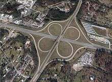
Interstate 75 traverses the county from the southwest to the north, passing through the western edge of Cleveland. There are four exits on I-75 in Bradley County: three in Cleveland and one in Charleston. U.S. Route 11 and U.S. Route 64 intersect in downtown Cleveland. U.S. 11 connects to Chattanooga to the southwest and Athens to the north. U.S. 64 connects to Murphy, North Carolina to the east. S.R. 60 connects Cleveland to Dayton to the northwest and Dalton, Georgia to the south. APD-40, made up of the U.S. 64 Bypass and a section of S.R. 60 forms a beltway and bypass route around the business district of Cleveland. The U.S. 11 Bypass bypasses downtown Cleveland to the west.[51]
Principal highways


- Paul Huff Parkway
Utilities
Cleveland Utilities is a city-owned corporation which provides electricity, water, and sewer service to the city of Cleveland and surrounding areas.[52] The Calhoun-Charleston Utilities District provides water to Charleston.[53] Volunteer Electric Cooperative (VEC) provides electricity to Charleston and the rest of Bradley County, except for a small portion in the southwestern part of the county along U.S. 11/64, including McDonald, which receives its electricity from Chattanooga-based EPB.[53] The rest of the county is provided water by the Hiwassee Utilities Commission, Ocoee Utility District, Eastside Utility District, and Savannah Valley Utility District.[53] Cleveland Utilities, VEC, and EPB all purchase their power from the Tennessee Valley Authority (TVA), which also provides power directly to heavy industries Olin, United Hydrogen, and Wacker. Chattanooga Gas, a subsidiary of Southern Company, provides natural gas to Cleveland and surrounding areas.[54]
Healthcare
The county's two main hospitals are Bradley Memorial Hospital and Cleveland Community Hospital. Prior to 2008, the two hospitals operated independently, when they were both purchased by SkyRidge Medical Center.[55] In 2015, the two hospitals were purchased by Tennova Healthcare.[56] Bradley Healthcare & Rehabilitation Center is a nursing home that serves the county. Bradley County Emergency Medical Services is an emergency medical service (EMS) agency of the county government that was established in 1972 and consists of three stations, eleven ambulances, and six ancillary vehicles, along with more than 60 full-time employees and more than 25 part-time employees.[57]
Education
Cleveland State Community College and Lee University are located in Bradley County. Public schools in the county are managed by the Bradley County Schools school district or the Cleveland City Schools school district. The county district has four public high schools: Bradley Central High School, Walker Valley High School, GOAL Academy, and REACH Adult High school. Cleveland High School is operated by the city school district. There is one State-accredited private Christian college preparatory school: Tennessee Christian Preparatory School.
Private schools
- Tennessee Christian Preparatory School
- Cleveland Christian School
- Bowman Hills Adventist School
- Shenandoah Baptist Academy
- United Christian Academy
- Vanguard Christian Academy
- Bachman Academy
Media
Newspapers
The Cleveland Daily Banner is the county's primary newspaper. The paper was first published in 1854, making it one of the oldest in the state.[58] Additionally, the Chattanooga Times Free Press, a paper based in Chattanooga, also serves as a primary source of news for Bradley County residents.
Radio
Several radio stations located within Chattanooga and neighboring cities serve Bradley County, along with others licensed to Cleveland, which are listed below:[59]
| Call sign | Frequency | Format |
|---|---|---|
| W207C1 (WAYW) | 89.3 FM | Contemporary Christian |
| WSAA | 93.1 FM | Air 1, Contemporary Christian |
| WALI | 97.1 | Lite rock |
| WOOP-LP | 99.9 FM | Country |
| WUSY | 100.7 FM | Country |
| W267BI | 101.3 FM | Talk |
| WCLE-FM | 104.1 FM | Adult contemporary |
| W290CA (WTSE) | 105.9 FM | Contemporary Christian |
| WBAC | 1340 AM | News/Talk |
| WCLE-AM | 1570 AM | Talk |
Communities


Cities
- Cleveland (county seat)
- Charleston
Census-designated places
Unincorporated communities
See also
References
- Corn, James F. (1959). Red Clay and Rattlesnake Springs: A History of the Cherokee Indians of Bradley County, Tennessee. Marceline, MO: Walsworth Publishing Company.
- Lillard, Roy G. (1980). Bradley County. Dunn, Joy Bailey., Crawford, Charles Wann, 1931-. Memphis, Tenn.: Memphis State University Press. ISBN 0878700994. OCLC 6934932.
Notes
- Seal of Bradley County, Tennessee
- John C. Bowman, "Bradley County," Tennessee Encyclopedia of History and Culture. Retrieved: March 31, 2013.
- "Bradley County, TN - Tennessee ZIP Codes". www.zip-codes.com.
- "State & County QuickFacts". United States Census Bureau. Retrieved November 29, 2013.
- "Find a County". National Association of Counties. Archived from the original on May 31, 2011. Retrieved June 7, 2011.
- Lillard 1980, p. 15-16.
- "Our Hometown 2016". Cleveland Daily Banner. Cleveland, Tennessee. August 6, 2016. Retrieved September 13, 2019.
- Lillard 1980, p. 37.
- Lillard 1980, p. 11.
- Lillard 1980, p. 12.
- Higgins, Randall (August 24, 2011). "Drive seeks $95,000 for historic Bradley site Rattlesnake Springs". Chattanooga Times Free Press. Chattanooga, Tennessee. Retrieved February 23, 2019.
- Lillard 1980, p. 17.
- William Snell, "Cleveland," An Encyclopedia of East Tennessee (Children's Museum of Oak Ridge, 1981), pp. 108-111.
- Temple, Oliver Perry (1899). East Tennessee and the Civil War. R. Clarke Company. p. 199.
- Jameson, W.C. (1997). Lost and Buried Treasures of the Civil War. Lyons Press. ISBN 1493040758.
- Temple, East Tennessee and the Civil War, pp. 370-406.
- W.E. Mathews Preston Diary and Regimental History, SPR393, Alabama Dept. of Archives and History, page 14. Archived February 25, 2014, at the Wayback Machine
- "Tennessee Civil War Trails Program," June 9, 2011, pp. 1-2. Accessed: March 12, 2015.
- "2010 Census Gazetteer Files". United States Census Bureau. August 22, 2012. Retrieved April 1, 2015.
- US Geological Survey (1965). Charleston, Tenn (Map). Washington, D.C.: U.S. Department of the Interior. Retrieved November 11, 2017.
- East Cleveland, Tennessee (Map). US Geological Survey. 1976. Retrieved November 12, 2017.
- "Population and Housing Unit Estimates". Retrieved July 20, 2019.
- "U.S. Decennial Census". United States Census Bureau. Retrieved April 1, 2015.
- "Historical Census Browser". University of Virginia Library. Retrieved April 1, 2015.
- Forstall, Richard L., ed. (March 27, 1995). "Population of Counties by Decennial Census: 1900 to 1990". United States Census Bureau. Retrieved April 1, 2015.
- "Census 2000 PHC-T-4. Ranking Tables for Counties: 1990 and 2000" (PDF). United States Census Bureau. April 2, 2001. Retrieved April 1, 2015.
- Based on 2000 census data
- "U.S. Census website". United States Census Bureau. Retrieved May 14, 2011.
- "Community Facts". data.census.gov. United States Census Bureau. Retrieved August 22, 2019.
- "U.S. Census website". United States Census Bureau. Retrieved August 22, 2019.
- "Welcome to Cleveland, Tennessee!". clevelandtn.gov. November 2, 2012. Archived from the original on August 5, 2013. Retrieved July 6, 2013.
- "Archived copy". Archived from the original on March 23, 2006. Retrieved December 29, 2005.CS1 maint: archived copy as title (link) Cleveland Chamber of Commerce
- Pare, Mike (June 2, 2017). "Wacker starts work on $150 million plant expansion in Bradley County". Chattanooga Times-Free Press. Retrieved October 26, 2017.
- Flessner, Dave (March 13, 2013). "Paper mill in Calhoun, Tenn., once known as Bowater, idles its last newsprint machine". Chattanooga Times Free Press. Retrieved November 11, 2017.
- "County Profile: Bradley County, Tennessee" (PDF). agcensus.usda.gov. U.S. Department of Agriculture. 2012. Retrieved June 18, 2018.
- Leip, David. "Dave Leip's Atlas of U.S. Presidential Elections". uselectionatlas.org. Retrieved March 10, 2018.
- County Commission - County Commissioners bradleycountytn.gov
- Constables by District bradleycountytn.gov
- County Mayor, Gary Davis bradleycountytn.gov
- "Key Dates for Voters" (PDF). bradleyelections.com. Bradley County Election Commission. 2018. Retrieved September 11, 2019.
- "Congressman Scott DesJarlais". United States House of Representatives. Retrieved November 19, 2017.
- "Congressman Chuck Fleischmann". United States House of Representatives. Retrieved November 19, 2017.
- Tennessee General Assembly (2017). State House District 22 (PDF) (Map). Nashville: Tennessee General Assembly. Retrieved November 19, 2017.
- Tennessee General Assembly (2017). State House District 24 (PDF) (Map). Nashville: Tennessee General Assembly. Retrieved July 7, 2014.
- Tennessee General Assembly (2017). State Senate District 9 (PDF) (Map). Nashville: Tennessee General Assembly. Retrieved November 19, 2017.
- Tennessee General Assembly (2017). State Senate District 10 (PDF) (Map). Nashville: Tennessee General Assembly. Retrieved November 19, 2017.
- Lilliard, Roy G. (1980). Bradley County. Memphis State University Press. p. 24. ISBN 0-87870-099-4.
- Love, Joyanna (December 29, 2013). "Cleveland's Hardwick Field officially closes Tuesday closes Tuesday". Clevelandbanner.com. Cleveland Daily Banner. Archived from the original on March 17, 2014. Retrieved March 16, 2014.
- Leach, Paul (December 27, 2013). "Cleveland's oldest airport, Hardwick Field, to close at year's end". Timesfreepress.com. Chattanooga Times Free Press. Retrieved March 16, 2014.
- Official Transportation Map (back) (PDF) (Map). TDOT. 2016. Archived from the original (PDF) on July 25, 2016. Retrieved November 1, 2017.
- "About CU". clevelandutilities.com. Cleveland Utilities. Retrieved February 15, 2019.
- "Bradley County Comprehensive Plan" (PDF). bradleycountytn.gov. 2013. Retrieved February 26, 2019.
- "Chattanooga Gas". aglresources.com. Southern Company. Archived from the original on February 23, 2019. Retrieved February 23, 2019.
- "Community forms Sky Ridge Medical Center". Medical News. Medical News. 2008. Archived from the original on April 7, 2014. Retrieved April 6, 2014.
- Report, Staff (September 30, 2015). "SkyRidge hospital renamed Tennova Healthcare-Cleveland". Chattanooga Times Free Press. Retrieved November 11, 2017.
- "Bradley County EMS". Bradleyco.net. Bradley County, TN. 2014.
- "Cleveland Daily Banner - Bradley County News Online Magazine". Archived from the original on October 10, 2007. Retrieved December 15, 2007.
- "Radio Stations in Cleveland, Tennessee". radiolocator.com. Radio Locator. Retrieved December 15, 2013.
- Pro Content and Design. "Television station listings in Cleveland, Tennessee". tvstations.procontentanddesign.com. Pro Content and Design. Archived from the original on December 1, 2008. Retrieved December 28, 2013.
External links
| Wikimedia Commons has media related to Bradley County, Tennessee. |
- Official site
- Bradley County Sheriff's Office
- Cleveland-Bradley Chamber of Commerce
- Bradley County on FamilySearch Wiki – genealogical resources
- TNGenweb
- Bradley County at Curlie
Places adjacent to Bradley County, Tennessee | ||||||||||
|---|---|---|---|---|---|---|---|---|---|---|
| ||||||||||
Municipalities and communities of Bradley County, Tennessee, United States | ||
|---|---|---|
| Cities | ||
| CDPs | ||
| Unincorporated communities | ||
| Footnotes | ‡This populated place also has portions in an adjacent county or counties | |

| Authority control |
|
|---|