Grainger County, Tennessee
Grainger County is a county located in the U.S. state of Tennessee. As of the 2010 census, the population was 22,657.[1] Its county seat is Rutledge.[2]
Grainger County | |
|---|---|
 Grainger County Courthouse in Rutledge | |
Logo | |
 Location within the U.S. state of Tennessee | |
 Tennessee's location within the U.S. | |
| Coordinates: 36°17′N 83°31′W | |
| Country | |
| State | |
| Founded | 1796 |
| Named for | Mary Grainger Blount |
| Seat | Rutledge |
| Largest city | Bean Station |
| Government | |
| • Mayor | Mike Byrd |
| Area | |
| • Total | 302 sq mi (780 km2) |
| • Land | 281 sq mi (730 km2) |
| • Water | 22 sq mi (60 km2) 7.2%% |
| Population | |
| • Estimate (2018) | 23,145 |
| • Density | 81/sq mi (31/km2) |
| Time zone | UTC−5 (Eastern) |
| • Summer (DST) | UTC−4 (EDT) |
| ZIP Codes | 37708, 37709, 37848, 37861, 37881, 37888 |
| Area code | 865, 423 (Bean Station area) |
| Congressional district | 2nd |
| Website | www |
Grainger County is a part of both the Knoxville Metropolitan Statistical Area and Morristown Metropolitan Statistical Area.[3]
History
Early years
Grainger County was formed from Knox and Hawkins Counties in 1796, the year Tennessee became the sixteenth state of the United States.[4] It is named for Mary Grainger Blount,[5] wife of William Blount. Anderson, Claiborne, Campbell, Hamblen, Hancock, Scott and Union Counties were formed from regions of the original Grainger County.[6]
Civil War
Like its surrounding East Tennessee counties, Grainger County was generally opposed to secession from the Union. In Tennessee's Ordinance of Secession referendum on June 8, 1861, sparsely populated Grainger County voters rejected secession by 1,756 to 495.[7]
During the American Civil War, a state of near-guerrilla warfare brought economic, political, and social chaos to Grainger County. Two arguments occurred within the county during the Civil War, with the first as a skirmish in Blaine around Christmas of 1862. In the year ahead, the Battle of Bean's Station pitted the forces of Confederate General James Longstreet against a Union army under General J.M. Shackleford in a planned surprise attack that failed for Confederate forces through the critically poor decision-making of Longstreet's staff.[8]
1900s to present day
After the creation of the Tennessee Valley Authority in the 1930s, many Grainger County residents had to be relocated for the construction of both Cherokee and Norris Dam in the southern and northern parts of the county. Bean Station experienced most of this loss, as a large original portion of the city now resides in the Cherokee Lake basin.[9]

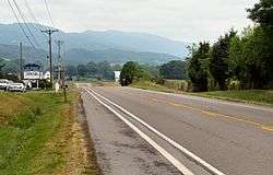
On May 13, 1972, 14 people were killed in a head-on collision between a Greyhound double-decker bus and a tractor-trailer hauling carpet on U.S. Route 11W in the Bean Station area of the county, making it the deadliest automobile accident of its time in Tennessee. This infamous crash, along with several other fatal crashes along the narrow two-lane stretch of U.S. Route 11W in Grainger County, gave it the nickname "Bloody Highway 11W."[10]
In July 2015, Grainger County received international attention and social media backlash after a hardware store owner in Washburn placed a ‘No gays allowed’ sign on the door of his business after the ruling of Obergefell v. Hodges by the Supreme Court of the United States.[11][12]
On April 5, 2018, Southeastern Provisions, a cattle slaughterhouse in the county,[13][14] was raided by U.S. Immigration and Customs Enforcement (ICE); 11 workers were arrested and 86 more were detained, all of whom were suspected of residing in the United States unlawfully.[13] At the time, the raid was reportedly the largest workplace raid in United States history.[14] In September 2018, the owner of the meatpacking facility was found guilty of multiple state and federal crimes, including tax evasion, wire fraud, contamination of local water supply, employing undocumented immigrants not authorized to work in the US, and other numerous workplace violations.[15][16]
Geography
According to the U.S. Census Bureau, the county has a total area of 302 square miles (780 km2), of which 281 square miles (730 km2) is land and 22 square miles (57 km2) (7.2%) is water.[17] Grainger County is bounded on the northwest by the Clinch River (impounded by Norris Dam to form Norris Lake) and on the southeast by the Holston River and Cherokee Lake.

Clinch Mountain is a major geographic feature that effectively separates the county into a southern section (including Bean Station, Blaine, Joppa, and Rutledge) and a northern section (including the communities of Washburn, Powder Springs, and Thorn Hill).
Indian Cave
Indian Cave is a historic site located on the Holston River near present-day Blaine. The cave was used for centuries before Europeans entered the area, as indigenous peoples settled in the area about 1000 CE.[18] Remains of cane torches and other artifacts located in the cave indicate use by prehistoric indigenous peoples.[19] The Iroquoian-speaking Cherokee migrated into the area from the northeast, making the eastern Ohio River valley and Appalachians down into South Carolina their historic territory.[18]
In the 1700s, a Cherokee village was located just west of the main cave entrance, before the people were pushed out by encroaching Anglo-American settlers.[20] The Donelson Party passed the Indian Cave entrance on their way down the Holston River in 1779 to settle present-day Nashville, Tennessee.[20] In the years after the American Revolutionary War, the number of settlers continued to increase. Under the Indian Removal Act of 1830, Congress authorized the president to remove the Indians from the Southeast to territory west of the Mississippi River.[18]
Robert Hoke, a former Confederate general from North Carolina, purchased the cave on July 21, 1869 as one of his business enterprises after the American Civil War. He had it mined for bat guano, a valuable natural fertilizer.[20]
Area businessmen formed the Indian Cave Park Association on January 4, 1916 to develop the cave as a commercial attraction, as was being done for other caves throughout the Great Smoky Mountains. The Association did not open the cave officially to the public until May 30, 1924. The cave is not open to visitors and is closed to the public as of 2005.[20]
Joppa Mountain

Joppa Mountain is located along the Clinch Mountain ridge in central Grainger County in the unincorporated community of Joppa. Buzzard Rock, is the summit of the mountain at an elevation of 2,530 feet (770 m) above sea level, making it one of the highest points in Grainger County. At this summit, the neighboring U.S. states of Georgia, Kentucky, North Carolina, and Virginia can be seen, along with the Cumberland Gap and the Great Smoky Mountains range, on a clear day.
Hang gliding from Joppa Mountain was a pastime of many hang gliding enthusiasts around the United States and the world. Hang gliding on Joppa Mountain gained momentum in the mid-1970s and enjoyed considerable popularity until the late 1980s.[21]
As of the present day, Buzzard Rock is inaccessible to hang gliders and hikers alike due to the property being closed to the public since the 1990s.
Waterways
The main source of water in Grainger County is man-made Cherokee Lake. Cherokee Lake was created during the 1940s as part of the Tennessee Valley Authority’s hydroelectric revitalization project. The lake is fed by multiple sources, including a series of natural creeks and runoff waters. The lake begins with its first source at Poor Valley Creek in Hawkins County, extends through Grainger County and neighboring Hamblen and Jefferson counties. Cherokee Lake ends at Cherokee Dam where the water is drained into the Holston River along the Grainger/Jefferson border. In total, Cherokee Lake has 28,780 acres of surface area and extends for 400 miles of shoreline.[22]
The Holston River below Cherokee Dam continues southwestward along the Grainger/Jefferson border passing the communities of New Corinth, Richland, and Blaine, then crossing into Knox County, with the confluence with the French Broad River in Knoxville, forming the Tennessee River.
In the northern part of the county, the Clinch River passes through Thorn Hill near the tri-border of Claiborne, Hancock and Grainger counties. The river then traverses northwestward along the Grainger/Claiborne border, flowing into the basin of Norris Lake north of Washburn and Liberty Hill. In total, Norris Lake has 33,840 acres of surface area and extends for 809 miles of shoreline that Grainger shares with Union, Claiborne, Campbell, and Anderson counties.[23]
Adjacent counties
- Claiborne County (north)
- Hancock County (northeast)
- Hawkins County (northeast)
- Hamblen County (east)
- Jefferson County (south)
- Knox County (southwest)
- Union County (west)
State protected areas
- Buffalo Springs Wildlife Management Area
- Johnson Ridge Small Wildlife Area
- TVA Noeton Resource Management Area
Demographics
| Historical population | |||
|---|---|---|---|
| Census | Pop. | %± | |
| 1800 | 7,367 | — | |
| 1810 | 6,397 | −13.2% | |
| 1820 | 7,651 | 19.6% | |
| 1830 | 10,066 | 31.6% | |
| 1840 | 10,572 | 5.0% | |
| 1850 | 12,370 | 17.0% | |
| 1860 | 10,962 | −11.4% | |
| 1870 | 12,421 | 13.3% | |
| 1880 | 12,384 | −0.3% | |
| 1890 | 13,196 | 6.6% | |
| 1900 | 15,512 | 17.6% | |
| 1910 | 13,888 | −10.5% | |
| 1920 | 13,369 | −3.7% | |
| 1930 | 12,737 | −4.7% | |
| 1940 | 14,356 | 12.7% | |
| 1950 | 13,086 | −8.8% | |
| 1960 | 12,506 | −4.4% | |
| 1970 | 13,948 | 11.5% | |
| 1980 | 16,751 | 20.1% | |
| 1990 | 17,095 | 2.1% | |
| 2000 | 20,659 | 20.8% | |
| 2010 | 22,657 | 9.7% | |
| Est. 2018 | 23,145 | [24] | 2.2% |
| U.S. Decennial Census[25] 1790-1960[26] 1900-1990[27] 1990-2000[28] 2010-2014[1] | |||

As of the census[30] of 2000, there were 20,659 people, 8,270 households, and 6,161 families residing in the county. The population density was 74 people per square mile (28/km²). There were 9,732 housing units at an average density of 35 per square mile (13/km²). The racial makeup of the county was 98.41% White, 0.32% Black or African American, 0.15% Native American, 0.09% Asian, 0.02% Pacific Islander, 0.40% from other races, and 0.61% from two or more races. 1.09% of the population were Hispanic or Latino of any race.
There were 8,270 households out of which 31.40% had children under the age of 18 living with them, 61.90% were married couples living together, 8.80% had a female householder with no husband present, and 25.50% were non-families. 22.50% of all households were made up of individuals and 9.10% had someone living alone who was 65 years of age or older. The average household size was 2.48 and the average family size was 2.89.
In the county, the population was spread out with 22.90% under the age of 18, 8.20% from 18 to 24, 30.50% from 25 to 44, 25.80% from 45 to 64, and 12.50% who were 65 years of age or older. The median age was 38 years. For every 100 females, there were 99.00 males. For every 100 females age 18 and over, there were 96.50 males.
The median age of a resident in Grainger County is 44.2.[31]
The median income for a household in the county was $27,997, and the median income for a family was $33,347. Males had a median income of $25,781 versus $19,410 for females. The per capita income for the county was $14,505. About 15.10% of families and 18.70% of the population were below the poverty line, including 22.40% of those under age 18 and 26.00% of those age 65 or over.
Economy
Agriculture
Agriculture has accounted for a large portion of the county economy throughout history due to the county’s soil containing a mass amount of rich nutrients.[32] The tomato has been the major crop, though cattle raising continues to important gains. Grainger County tomatoes have in recent decades become nationally renowned.[33]
The county celebrates the tomato in an annual festival since 1992. Around fifty-thousand festival-goers across the state of Tennessee and the United States flock to witness events about the county’s heritage and its significant agricultural impact across the state of Tennessee, enjoy live music performances, purchase local produce and handmade gifts, and take part in arts and crafts events. The Grainger County Tomato Festival takes place during the final weekend in July.[34]
Tourism and leisure

By the late 19th century, a tourism industry had flourished around the mineral springs flowing from the Clinch Mountain range. The Tate Springs Resort complex located in the Bean Station region of the county, provided accommodations for tourists and business travelers alike until the Great Depression. It included mineral baths and waters, an enormous resort hotel, a swimming pool and bathhouse, a springhouse constructed as a gazebo, private cabins, and a golf course. After the Great Depression, the resort had closed and the property was given to local authorities. A children’s home and school occupied the space of the hotel and cabins, until a major fire destroyed the entire hotel in the 1960s. Today, the Tate Springs Springhouse, the bathhouse, and several cabins are what remains of the complex.[35]

Since the 1940s, the county’s tourism and recreational industry nonetheless sparked once again after the Tennessee Valley Authority's creation of Cherokee and Norris Lake in the southern and northern parts of the county respectively. Fishing, hiking, hunting, camping, golf, boating, water sports, and development of lakefront property seek to continue contributing to the county's economy.[36]
Industry and commerce
In the county’s early years, small businesses represented the secondary source of economic development. Gristmills, hatters, saddle makers, tailors, lawyers, and dry goods merchants supplied the many necessities for the county's isolated and spread-out agricultural communities.[37]
The Shields family operated Holston Paper Mill, one of the earliest local industries in the county. The Knoxville and Bristol Railroad, also known as the Peavine Railroad, ran through the Richland Creek Valley from Bean Station to Blaine. The tracks would later succumb to flooding after the damming of the Richland Valley by TVA.[38]
Clinchdale Lumber Company, a locally owned business, logged a significant portion of the county's timber in the early part of the 20th century. Afterwards, this timbering movement gave way to knitting mills and zinc mining in the Clinch River Valley in the northern part of the county.[39] Around the late 20th century, Tennessee marble was quarried in the Thorn Hill area of Grainger County.[40]
Unlike neighboring counties such as Jefferson, Hamblen, and Knox, Grainger County does not have zoning ordinances.[41] Many residents and businesses outside of Blaine and Rutledge do not have currently any access to a wastewater treatment system.[42] These issues, along with a rural brain drain of young college-educated individuals leaving Grainger County for urban economic centers such as Knoxville,[43] has caused economic growth to dwindle drastically.
Nearly two-thirds of Grainger County residents commute to cities in surrounding counties such as Morristown and Knoxville for work.[44]
In the fiscal year 2019, Grainger County was recognized as one of twenty-four counties in the state of Tennessee at risk of becoming economically distressed.[45]
Communities
Cities
- Bean Station
- Rutledge (county seat)
- Blaine
Unincorporated communities
- Avondale
- Beech Grove
- Bowen
- Cherokee
- Elm Springs
- Joppa
- Liberty Hill
- Mary’s Chapel
- New Corinth
- Powder Springs
- Tater Valley
- Thorn Hill
- Washburn
Education
The Grainger County Schools district has one high school, one middle school, four elementary/intermediate schools, one primary school, one K-12 school, and one alternative-placement school. The current superintendent of Grainger County Schools is Dr. James Atkins. As of the 2019–2020 school year, the Grainger County Schools district has 3,637 students enrolled.[46]
Primary School
- Rutledge Primary School
Elementary Schools
- Bean Station Elementary School
- Joppa Elementary School
- Rutledge Elementary School
- Washburn School
Middle School
- Rutledge Middle School
High Schools
- Grainger High School
- Washburn School
Alternative School
- Grainger Academy
Government and politics
| Year | Republican | Democratic | Third Parties |
|---|---|---|---|
| 2016 | 82.7% 6,626 | 14.4% 1,154 | 2.9% 228 |
| 2012 | 75.4% 5,470 | 23.0% 1,668 | 1.6% 114 |
| 2008 | 70.6% 5,297 | 27.5% 2,066 | 1.9% 140 |
| 2004 | 65.2% 4,907 | 34.1% 2,569 | 0.7% 51 |
| 2000 | 60.5% 3,746 | 38.1% 2,361 | 1.4% 87 |
| 1996 | 52.7% 2,875 | 39.7% 2,162 | 7.6% 416 |
| 1992 | 49.9% 2,772 | 40.4% 2,242 | 9.7% 539 |
| 1988 | 65.5% 2,734 | 34.1% 1,423 | 0.4% 17 |
| 1984 | 66.7% 3,212 | 32.5% 1,565 | 0.8% 37 |
| 1980 | 67.1% 3,254 | 30.8% 1,495 | 2.0% 99 |
| 1976 | 57.7% 2,805 | 41.5% 2,018 | 0.8% 40 |
| 1972 | 76.5% 2,842 | 22.3% 828 | 1.2% 43 |
| 1968 | 67.3% 2,788 | 18.4% 761 | 14.4% 596 |
| 1964 | 66.8% 2,634 | 33.2% 1,309 | |
| 1960 | 75.9% 3,017 | 23.6% 939 | 0.5% 21 |
| 1956 | 72.4% 2,497 | 26.5% 913 | 1.1% 39 |
| 1952 | 76.3% 3,030 | 23.6% 937 | 0.1% 5 |
| 1948 | 71.8% 1,824 | 25.3% 644 | 2.9% 74 |
| 1944 | 76.0% 1,938 | 23.7% 605 | 0.3% 7 |
| 1940 | 66.0% 1,688 | 32.9% 842 | 1.1% 27 |
| 1936 | 60.2% 1,754 | 39.5% 1,153 | 0.3% 9 |
| 1932 | 56.3% 1,325 | 42.3% 995 | 1.4% 33 |
| 1928 | 75.3% 1,457 | 24.1% 466 | 0.6% 12 |
| 1924 | 68.8% 1,464 | 30.6% 651 | 0.6% 13 |
| 1920 | 70.7% 2,158 | 29.3% 895 | 0.0% 1 |
| 1916 | 64.4% 1,529 | 35.5% 843 | 0.1% 3 |
| 1912 | 29.9% 741 | 33.9% 841 | 36.3% 900 |
Like all of East Tennessee, Grainger County has long been overwhelmingly Republican, due to its powerful Unionist sentiment during the Civil War.[48] The last Democratic presidential candidate to ever carry Grainger County was Andrew Jackson in 1832. The Whig Party carried the county consistently between 1836 and 1852, and since the Republican Party first contested Tennessee in 1868, it has won Grainger County in every election except in 1912 when the GOP was mortally divided and Progressive Theodore Roosevelt carried the county over conservative incumbent William Howard Taft.
In recent elections, the county has shown little competitiveness for Democratic candidates in local, state, and federal elections.
Grainger County’s current mayor is Mike Byrd. The county has 15 commissioners, three from each of its five districts.
References
- "State & County QuickFacts". United States Census Bureau. Archived from the original on June 7, 2011. Retrieved November 30, 2013.
- "Find a County". National Association of Counties. Archived from the original on 2011-05-31. Retrieved 2011-06-07.
- "Revised Delineations of Metropolitan Statistical Areas, Micropolitan Statistical Areas, and Combined Statistical Areas, and Guidance on Uses of the Delineations of These Areas" (PDF). Office of Management and Budget. Retrieved April 27, 2014.
- Kevin Collins, "Grainger County," Tennessee Encyclopedia of History and Culture. Retrieved: October 20, 2013
- Gannett, Henry (1905). The Origin of Certain Place Names in the United States. Govt. Print. Off. pp. 141.
- "Grainger County Archives". www.graingerarchives.org. Retrieved 2018-03-10.
- Oliver Perry Temple, East Tennessee and the Civil War (R. Clarke Company, 1899), p. 199.
- Collins, Kevin (October 8, 2017). "Grainger County". TennesseeEncyclopedia.net. Tennessee Historical Society. Retrieved March 13, 2020.
- Collins, Kevin (October 8, 2017). "Grainger County". TennesseeEncyclopedia.net. Tennessee Historical Society. Retrieved March 13, 2020.
- Lakin, Matt (August 26, 2012). "Blood on the asphalt: 11W wreck left 14 people dead". Knoxville News Sentinel. Retrieved October 21, 2017.
- "Tennessee hardware store puts up 'No Gays Allowed' sign". USA Today. July 1, 2015. Retrieved June 10, 2020.
- Perry, Tod (February 2, 2019). "After a bigoted hardware store owner posted a 'No Gays Allowed' sign, he got roasted on Yelp". Good. Retrieved June 10, 2020.
- Dorman, Travis; Satterfield, Jamie (April 5, 2018). "ICE raids Grainger County meatpacking plant amid charges owners avoided $2.5M in payroll taxes". Knox News. Retrieved April 7, 2018.
- Burke, Sheila (April 6, 2018). "Immigration raid takes 97 into custody at Tennessee plant". ABC News. Retrieved April 7, 2018.
- Lakin, Matt (September 12, 2018). "Bean Station ICE raid: Slaughterhouse owner pleads guilty to hiring undocumented workers". Knoxville News-Sentinel. Knoxville, Tennessee. Retrieved 2019-07-28.
- "2018 Grainger County ICE raid subject of Netflix documentary". WATE 6 On Your Side. 2019-12-19. Retrieved 2019-12-22.
- "2010 Census Gazetteer Files". United States Census Bureau. August 22, 2012. Retrieved April 5, 2015.
- "History of Great Smoky Mountain Park" Archived 2012-10-04 at the Wayback Machine, Knoxville, Tennessee Information Gateway, accessed 26 May 2012
- Larry E. Matthews, Chapter 4: "Indian Cave", Caves of Knoxville and the Great Smoky Mountains, National Speleological Society, 2008, ISBN 978-1-879961-30-2, pp. 83-104
- Matthews (2008), "Caves of Knoxville", pp. 83-104
- East Tennessee Economic Development Agency. "Grainger County". ETEDA.org. Retrieved April 7, 2020.
- "Cherokee Lake". CherokeeLake.org. Retrieved March 15, 2020.
- "About Norris Lake". norrislake.com. Retrieved June 10, 2020.
- "Population and Housing Unit Estimates". Retrieved July 20, 2019.
- "U.S. Decennial Census". United States Census Bureau. Retrieved April 5, 2015.
- "Historical Census Browser". University of Virginia Library. Retrieved April 5, 2015.
- Forstall, Richard L., ed. (March 27, 1995). "Population of Counties by Decennial Census: 1900 to 1990". United States Census Bureau. Retrieved April 5, 2015.
- "Census 2000 PHC-T-4. Ranking Tables for Counties: 1990 and 2000" (PDF). United States Census Bureau. April 2, 2001. Retrieved April 5, 2015.
- Based on 2000 census data
- "U.S. Census website". United States Census Bureau. Retrieved 2011-05-14.
- "Grainger County, TN". DataUSA.io. Retrieved May 18, 2020.
- Bertone, Rachel (March 13, 2017). "Why Grainger County, Tennessee, Tomatoes Are So Tasty". Farm Flavor. Retrieved March 14, 2020.
- Collins, Kevin (October 8, 2017). "Grainger County". TennesseeEncyclopedia.net. Tennessee Historical Society. Retrieved March 13, 2020.
- "Grainger County Tomato Festival TN". Grainger County Tomato Festival TN. Retrieved 2017-11-15.
- Collins, Kevin (October 8, 2017). "Grainger County". TennesseeEncyclopedia.net. Tennessee Historical Society. Retrieved March 13, 2020.
- Collins, Kevin (October 8, 2017). "Grainger County". TennesseeEncyclopedia.net. Tennessee Historical Society. Retrieved March 13, 2020.
- Collins, Kevin (October 8, 2017). "Grainger County". TennesseeEncyclopedia.net. Tennessee Historical Society. Retrieved March 13, 2020.
- Carruthers, Amelia (1943). "Bean Station". National History Magazine. 77: 31–35.
- Coffey, Ken (June 10, 2020). "Polly Cole: The Thorn Hill Prospector". Grainger Today. Retrieved June 17, 2020.
- University of Tennessee, Department of Geological Sciences (1985). "The geological history of the Thorn Hill Paleozoic section (Cambrian-Mississippian)". SE-GSA 1985: 128.
- Wolfe, Tracey (April 10, 2019). "Zoning plan update generates heated discussion". Grainger Today. Retrieved March 14, 2020.
- Turner, Robert (April 17, 2018). "Sewer or property taxes?: Bean Station workshop begins budget talks". Grainger Today. Retrieved March 14, 2020.
- "2019 Annual Report" (PDF). Comprehensive Economic Development Strategy (CEDS): 32. January 14, 2020 – via East Tennessee Development District.
- East Tennessee Development District (April 1, 2012). "Grainger County 2010 Census Report" (PDF). ETDD.org. Retrieved May 8, 2020.
- State of Tennessee, Transparent Tennessee. "Distressed Counties". TN.gov. Retrieved March 16, 2020.
- "Grainger County School District". Niche. Retrieved 2020-03-18.
- Leip, David. "Dave Leip's Atlas of U.S. Presidential Elections". uselectionatlas.org. Retrieved 2018-03-10.
- "Grainger County Election Commission". graingercoelectioncommission.com. Retrieved 2017-11-16.
External links
| Wikimedia Commons has media related to Grainger County, Tennessee. |
- Official county government website
- Grainger County Chamber of Commerce website
- Grainger County Schools website
- Hear it spoken (Voice of Former Grainger County Mayor Mark Hipsher, 2010)
Places adjacent to Grainger County, Tennessee | ||||||||||
|---|---|---|---|---|---|---|---|---|---|---|
| ||||||||||
Municipalities and communities of Grainger County, Tennessee, United States | ||
|---|---|---|
| Cities | ||
| Unincorporated communities | ||
| Principal City |   | |
|---|---|---|
| Other Cities | ||
| Counties | ||

| Authority control |
|
|---|