Boundaries between the continents of Earth
The boundaries between the continents of Earth are generally a matter of geographical convention. Several slightly different conventions are in use. The number of continents is most commonly considered seven but may range as low as four when the Americas and Afro-Eurasia are each considered a single continent. An island can be continental, and therefore associated with the continent on the same continental plate, or oceanic and associated with a continent or geographic region by convention.
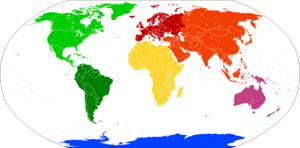
Americas
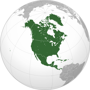
North America
South America
Afro-Eurasia
Eurasia
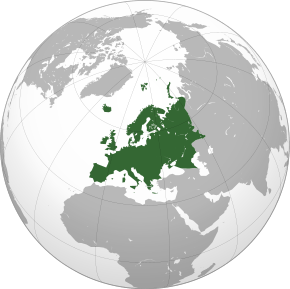
Europe
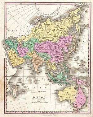
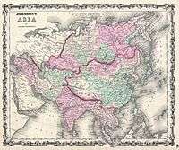
Asia
Africa
Australia
Antarctica
There are three overland boundaries subject to definition:
- between Europe and Asia (dividing Eurasia): along the Turkish Straits, the Caucasus, and the Urals and the Ural River (historically also north of the Caucasus, along the Kuma–Manych Depression or along the Don River)
- between Asia and Africa (dividing Afro-Eurasia into Africa and Eurasia): at the Isthmus of Suez
- between North America and South America (dividing the Americas): at some point on the Isthmus of Panama, with the most common demarcation in atlases and other sources following the Darién Mountains watershed that divides along the Colombia–Panama border where the isthmus meets the South American continent (see Darién Gap)
While the isthmus between Asia and Africa and that between North and South America are today navigable, via the Suez and Panama canals, respectively, diversions and canals of human origin generally are not accepted on their own accord as continent-defining boundaries; the Suez Canal happens to traverse the isthmus between the Mediterranean Sea and Red Sea, dividing Asia and Africa.
The remaining boundaries concern the association of islands and archipelagos with specific continents, notably:
- the delineation of Southeast Asia from Australia in the Ceram Sea, Arafura Sea, Timor Sea, Halmahera Sea, and Malay Archipelago
- the delineation between Africa, Europe and Asia in the Mediterranean Sea
- the delineation between Asia and Europe in the Arctic Ocean
- the delineation between Europe and North America in the Atlantic Ocean
- the delineation between North and South America in the Caribbean Sea
- the delineation of Asia from North America in the North Pacific Ocean
- the delineation of Antarctica from South America, Africa and Australia in the South Atlantic Ocean, South Indian Ocean and South Pacific Ocean, respectively (referred to collectively by some geographers as the Southern Ocean or the Antarctic Ocean).
Europe and Africa
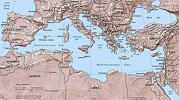
The European and African mainlands are non-contiguous, and the delineation between these continents is thus merely a question of which islands are to be associated with which continent.
The Portuguese Atlantic island possession of the Azores is 1,368 km (850 mi) from Europe and 1,507 km (936 mi) from Africa, and is usually grouped with Europe if grouped with any continent. By contrast, the Canary and Madeira islands (including the Desertas Islands and the Savage Islands) off the Atlantic coast of Morocco are much closer to, and usually grouped with, Africa (the Canary Islands are only 100 km (62 mi) from the African coast at their closest point, while Madeira is 520 km (320 mi) from Africa and 1,000 km (620 mi) from Europe).[1]
The Mediterranean island nation of Malta is about 81 km (50 mi) from the coast of Sicily in Europe - much closer than the 288 km (179 mi) distance to the closest African coast. The nearby Italian island of Lampedusa (principal island of the Pelagie Islands) is 207 km (129 mi) from Sicily while just 127 km (79 mi) from the African coast; similarly, Pantelleria is 100 km (62 mi) from Sicily and just 71 km (44 mi) from the African coast. All of these Mediterranean islands are actually located on the African plate, and may be considered part of the continent of Africa.[2][3] However, for political and historical reasons, maps generally display them as part of Europe. A single Spanish islet, known as Alboran Island, is also debatably located on either the African plate or the Eurasian plate. This island is located in the Alboran Sea, 50 km (31 mi) north of the Moroccan coast and 90 km (56 mi) south of Spain.
European-governed territory in Africa
There are six definitive occurrences of territories unequivocally being a part of the African continent, but legally being administered by a European state. Three of these are administered by France, and three of these are administered by Spain. The existence of these territories further blurs the line between the borders of Africa and Europe, in particular with regard to the Spanish territories which lie immediately adjacent to and/or connected to the African mainland. The French territories lie within the Indian Ocean, and, consequently, are more dislocated from the principal boundary between the two continents.
The Spanish uninhabited territories known as the Plazas de soberanía ("Places of Sovereignty") are minor islands that lie immediately adjacent to the North African coastline, with the exception of Peñón de Vélez de la Gomera which was originally an island like the other 'places', but has subsequently become directly connected to the Moroccan (African) coastline. The two other Spanish territories are the exclaves of Ceuta and Melilla, which are two populated coastal cities located directly on the African mainland, both bordering Morocco solely.
Two of the French territories are the inhabited overseas departments and regions of Réunion and Mayotte. Réunion is an island territory located near the island nation of Mauritius and to the east of island nation of Madagascar (both nominally considered a part of the African continent). Mayotte is an island territory located west of Madagascar within the Mozambique channel. The final territory is the Scattered Islands in the Indian Ocean, administratively a part of the French Southern and Antarctic Lands. This French territory consists of a range of minor uninhabited island atolls in the Indian Ocean, located in the deep sea surrounding Madagascar.
Europe and Asia
The boundary between Europe and Asia is unusual among continental boundaries because of its largely mountain-and-river-based characteristics north and east of the Black Sea. The reason is historical, the division of Europe and Asia going back to the early Greek geographers. In the modern sense of the term "continent", Eurasia is more readily identifiable as a "continent", and Europe has occasionally been described as a subcontinent of Eurasia.[4]
History
- Differing boundaries between Europe and Asia
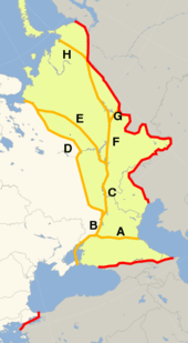 Conventions used for the boundary between Europe and Asia during the 18th and 19th centuries. The red line shows the most common modern convention, in use since c. 1850 (see below).EuropeAsiahistorically placed in either continent
 Red line "A" was commonly accepted in Russia and Kazakhstan during the Soviet Union era. The commonly accepted modern definition mostly fits with the lines "B" and "F" in this image.
 Transcontinental states, European territoryTranscontinental states, Asian territory
The threefold division of the Old World into Europe, Asia and Africa has been in use since the 6th century BC, due to Greek geographers such as Anaximander and Hecataeus.[4]
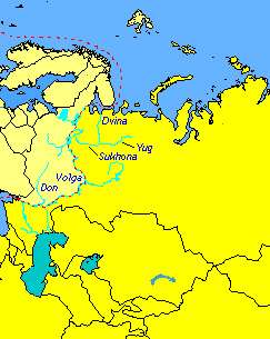
Anaximander placed the boundary between Asia and Europe along the Phasis River (the modern Rioni) in the Caucasus (from its mouth by Poti on the Black Sea coast, through the Surami Pass and along the Kura River to the Caspian Sea), a convention still followed by Herodotus in the 5th century BC.[5] As geographic knowledge of the Greeks increased during the Hellenistic period,[6] this archaic convention was revised, and the boundary between Europe and Asia was now considered to be the Tanais (the modern Don River). This is the convention used by Roman era authors such as Posidonius,[7] Strabo[8] and Ptolemy.[9]
Throughout the Middle Ages and into the 18th century, the traditional division of the landmass of Eurasia into two continents, Europe and Asia, followed Ptolemy, with the boundary following the Turkish Straits, the Black Sea, the Kerch Strait, the Sea of Azov and the Don (known in antiquity as the Tanais). But maps produced during the 16th to 18th centuries tended to differ in how to continue the boundary beyond the Don bend at Kalach-na-Donu (where it is closest to the Volga, now joined with it by the Volga–Don Canal), into territory not described in any detail by the ancient geographers.
Philip Johan von Strahlenberg in 1725 was the first to depart from the classical Don boundary by drawing the line along the Volga, following the Volga north until the Samara Bend, along Obshchy Syrt (the drainage divide between Volga and Ural) and then north along Ural Mountains.[10][11] The mapmakers continued to differ on the boundary between the lower Don and Samara well into the 19th century. The 1745 atlas published by the Russian Academy of Sciences has the boundary follow the Don beyond Kalach as far as Serafimovich before cutting north towards Arkhangelsk, while other 18th- to 19th-century mapmakers such as John Cary followed Strahlenberg's prescription. To the south, the Kuma–Manych Depression was identified circa 1773 by a German naturalist, Peter Simon Pallas, as a valley that, once upon a time, connected the Black Sea and the Caspian Sea,[11][12] and subsequently was proposed as a natural boundary between continents.
By the mid-19th century, there were three main conventions, one following the Don, the Volga–Don Canal and the Volga, the other following the Kuma–Manych Depression to the Caspian and then the Ural River, and the third abandoning the Don altogether, following the Greater Caucasus watershed to the Caspian. The question was still treated as a controversy in geographical literature of the 1860s, with Douglas Freshfield advocating the Caucasus crest boundary as the best possible, citing support from various modern geographers.[13]
In Russia and the Soviet Union, the boundary along the Kuma–Manych Depression was the most commonly used as early as 1906.[14] In 1958, the Soviet Geographical Society formally recommended that the boundary between the Europe and Asia be drawn in textbooks from Baydaratskaya Bay, on the Kara Sea, along the eastern foot of Ural Mountains, then following the Ural River until the Mugodzhar Hills, and then the Emba River; and Kuma–Manych Depression,[15] thus placing the Caucasus entirely in Asia and the Urals entirely in Europe.[16] However, most geographers in the Soviet Union favoured the boundary along the Caucasus crest[17] and this became the standard convention in the latter 20th century, although the Kuma–Manych boundary remained in use in some 20th-century maps.
Modern definition
_(5).jpg)
The modern border between Asia and Europe remains a historical and cultural construct, defined only by convention. The modern border follows the Aegean Sea, the Dardanelles–Sea of Marmara–Bosphorus (together known as the Turkish Straits), the Black Sea, along the watershed of the Greater Caucasus, the northwestern portion of the Caspian Sea and along the Ural River and Ural Mountains to the Kara Sea, as mapped and listed in most atlases including that of the National Geographic Society and as described in the World Factbook.[18][19] According to this definition, Georgia and Azerbaijan both have most of their territory in Asia, although each has small parts of their northern borderlands north of the Greater Caucasus watershed and thus in Europe.[20]
Though most geographic sources assign the area south of the Caucasus Mountain crest to Southwest or West Asia,[21] no definition is entirely satisfactory, with it often becoming a matter of self-identification. Cultural influences in the area originate from both Asia and Europe. While geographers rarely define continents primarily politically, Georgia and to a lesser extent Armenia and Azerbaijan are increasingly in the 21st century politically oriented towards Europe, but Armenia has a great cultural diaspora to the south, and Azerbaijan shares a cultural affinity with Iranian Azerbaijan as well as with the Turkic countries of Central Asia.[22]
The Turkish city Istanbul lies in on both sides of the Bosporus (one of the Turkish Straits), making it a transcontinental city. Russia and Turkey are transcontinental countries with territory in both Europe and Asia by any definition except that of Eurasia as a single continent. While Russia is historically a European country with a history of imperial conquests in Asia, the situation for Turkey is inverse, as that of an Asian country with imperial conquests in Europe. Kazakhstan is also a transcontinental country by this definition, its West Kazakhstan and Atyrau provinces extending on either side of the Ural River.[23]
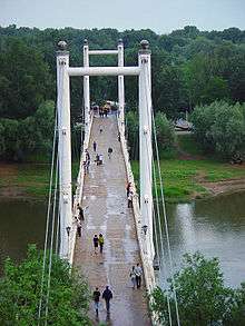
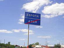
This Ural River delineation is the only segment not to follow a major mountain range or wide water body, both of which often truly separate populations. However, the Ural River is the most common division used by authorities,[18][23][24] is the most prominent natural feature in the region, and is the "most satisfactory of those (options) proposed"[25] which include the Emba River, a much smaller stream cutting further into Central Asian Kazakhstan. The Ural River bridges in Atyrau and Orenburg are even labeled with permanent monuments carved with the word "Europe" on one side, "Asia" on the other.[26]
The Kuma–Manych Depression (more precisely, the Manych River, the Kuma–Manych Canal and the Kuma River) remains cited less commonly as one possible natural boundary in contemporary sources.[27] This definition peaked in prominence in the 19th century, however it has declined in usage since then, as it places traditionally European areas of Russia such as Stavropol, Krasnodar, and even areas just south of Rostov-on-Don in Asia.
A lesser known definition for country grouping, is the definition used for statistical purposes by the United Nations Statistics Division (UNSD):[28]
- listed as part of Eastern Europe: Russian Federation
- listed as part of Central Asia: Kazakhstan
- listed as part of Western Asia: Armenia, Azerbaijan, Cyprus, Georgia, and Turkey
According to UNSD, the aforementioned "assignment of countries or areas to specific groupings is for statistical convenience and does not imply any assumption regarding political or other affiliation of countries or territories".[29] Furthermore, the UNSD classification often differs from those of other United Nations organizations. For instance, while UNSD includes Georgia and Cyprus in Western Asia, the United Nations Industrial Development Organization and UNESCO include both countries in Europe.[30][31]
The Council of Europe includes the Eurasian countries of Armenia, Azerbaijan, Cyprus, Georgia, Russia, and Turkey. It notes that
[T]wo Council of Europe member States, Turkey and Russia, belong geographically to both Europe and Asia and are therefore Eurasian. Strictly speaking, the three South Caucasus States, Armenia, Azerbaijan and Georgia are located in Asia, yet their membership of political Europe is no longer in doubt.[32]
Islands
Cyprus is an island of the Mediterranean located close to Asia Minor, so that it is usually associated with Asia and/or the Middle East, as in the World Factbook and the United Nations geoscheme, but the Republic of Cyprus was nevertheless admitted to the Council of Europe in 1961 and joined the EU in 2004. The northern part of the island functions as the unrecognized (except by Turkey) Turkish Republic of Northern Cyprus.
The Greek North Aegean Islands and the Dodecanese lie on the coast of the Asian part of Turkey (on the Asian continental shelf). Thus, generally, these island groups could be considered a part of Asia. More specifically, the small islands of Kastellorizo, Strongyli Megistis, and Ro (all these islands are still in the Dodecanese group) are directly to the south of the Turkish Anatolia coastline, of which they are directly adjacent. Additionally, they lie at some distance to the east of the rest of the Dodecanese group in the direction of Cyprus and the Turkish city of Antalya. Akin to Cyprus, these small islets would nominally be considered Asian if only the continental shelf were used to define the boundary, ignoring historical and cultural influences on the boundary.
Russia's Vaygach Island and Novaya Zemlya extend northward from the northern end of the Ural Mountains and are a continuation of that chain into the Arctic Ocean. While Novaya Zemlya was variously grouped with Europe or with Asia in 19th-century maps it is now usually grouped with Europe, the continental boundary considered to join the Arctic Ocean along the southern shore of the Kara Sea. The Russian Arctic archipelago of Franz Josef Land farther north is also associated with Europe.
| Map | Description |
|---|---|
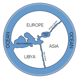 |
Map of the world according to Anaximander (6th century BC). Only the parts of Europe, Asia and Africa directly adjacent to the Mediterranean and the Black Sea are known. The Phasis River of the Caucasus in Georgia is imagined as separating Europe from Asia, while the Nile separates Asia from Africa (Libya). |
 |
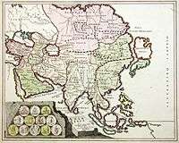
In this 1570 map of Asia (Asiae Nova Descriptio), the Tanais is used as continental boundary. Moscovia is represented as "transcontinental", having an Asiatic and a European part (labelled Europae pars). |
 |
This 1719 map of "ancient Asia" (Asia Vetus) divides Sarmatia into Sarmatia Europea and Sarmatia Asiatica. The continental boundary is drawn along the Tanais (Don), the Volga and the Northern Dvina. |
 |
Herman Moll (c. 1715) draws the boundary along the Don, the Volga, cutting across land from Samara to the Tobol River, following the lower Irtysh and finally the Ob River, placing Novaya Zemlya in Europe. |
 |
A German map of 1730 by Johann Christoph Homann has a similar boundary to the one shown by Moll, but following the full length of the Samara bend and then cutting across to the Irtysh directly, placing the Tobol and Tobolsk in Asia. |
.jpg) |
The "Academy Atlas" of the Russian Empire, published by The Saint Petersburg Academy of Sciences in 1745, draws the boundary along the Don, but then west of the Volga to Arkhangelsk |
_1803.jpg) |
1803 Cedid Atlas (Ottoman Empire), draws the boundary along the Don, Volga and River Kama and then cuts northwards to Khaypudyr Bay. Novaya Zemlya is in Europe. |
 |
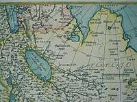
1806 map of Asia by John Cary, boundary along the Don and then the Volga until Samara, and north of Perm following the Urals, placing Novaya Zemlya in Asia. |
 |
1827 map by Anthony Finley, showing the boundary as running along the Don, the Volga, passing between Perm and Ufa, and running north over land to the Sea of Kara, placing Novaya Zemlya in Europe. |
|
|
1861 map by A. J. Johnson, illustrating the modern convention, Caucasus crest, Ural River, Urals. |
 |
1914 map showing the boundary along the Manych River, placing Stavropol Krai in Asia |
 |
Miles Clark in his 1992 "circumnavigation of Europe" followed the White Sea – Baltic Canal until Lake Onega and the Volga–Baltic Waterway to the Rybinsk Reservoir before joining the classical boundary along the Volga and Don rivers.[33][34] |
Europe and North America
The geographical notion of a continent stands in opposition to islands and archipelagos.[35] Nevertheless, there are some islands that are considered part of Europe in a political sense. This most notably includes the British Isles (part of the European continental shelf and during the Ice Age of the continent itself); the islands of the North Sea, the Baltic Sea, and the Mediterranean that are part of the territory of a country situated on the European mainland; the Azores on the Mid-Atlantic Ridge, part of Portugal; and usually also the island states of Iceland (part of Norway and/or Denmark from 13th to early 20th centuries) and Malta.
The Norwegian islands of Jan Mayen and Svalbard in the Arctic Ocean are usually associated with Europe.
South of the Arctic, Europe and North America are separated by the North Atlantic. In terms of associating its oceanic islands with either continent, the boundary is usually drawn between Greenland and Iceland and between Bermuda and the Azores’ Grupo Ocidental (Western Group)—all other North Atlantic islands are continental. Iceland and the Azores are protrusions of the Mid-Atlantic Ridge and are associated with and peopled from Europe, even though they have areas on the North American Plate. (Definitions of "continents" are a physical and cultural construct dating back centuries, long before the advent or even knowledge of plate tectonics; thus, defining a "continent" falls into the realm of physical and cultural geography[i.e.Geopolitics ], while continental plate definitions fall under plate tectonics in the realm of geology.)
Greenland is geographically part of North America. Politically, however, it is more associated with Europe as it is part of the Kingdom of Denmark, although it has extensive home rule and EU law no longer applies there.
Three islands in the Caribbean are legally a direct part of the Netherlands, that is the Caribbean Netherlands (Bonaire, Saba and Sint Eustatius). Two islands in the Caribbean are legally a direct part of France, Guadeloupe and Martinique.
Africa and Asia
Historically in Greco-Roman geography, "Africa" meant Ancient Libya, and its eastern extent was taken to be around Marmarica, at the Catabathmus Magnus, placing Egypt in Asia entirely. The idea of Egypt being an "African" country seems to develop in around the mid-19th century; the term Africa was classically reserved for what is now known as the Maghreb, to the explicit exclusion of Egypt, but with the exploration of Africa the shape of the African landmass (and Egypt's "natural" inclusion in that landmass) became apparent. In 1806, William George Browne still titled his travelogue Travels in Africa, Egypt, and Syria. Similarly, James Bruce in 1835 published Travels through part of Africa, Syria, Egypt, and Arabia. On the other hand, as early as 1670 John Ogilby under the title Africa published "an accurate Description of the Regions of Egypt, Barbary, Libya, and Billedulgerid, the Land of Negroes, Guinea, Æthiopia, and the Abyssines, with all the adjacent Islands, either in the Mediterranean, Atlantic, Southern, or Oriental Seas, belonging thereunto".
The usual line taken to divide Africa from Asia today is at the Isthmus of Suez, the narrowest gap between the Mediterranean and Gulf of Suez, the route today followed by the Suez Canal. This makes the Sinai Peninsula geographically Asian, and Egypt a transcontinental country. Less than 2% of Egyptian population live in the Sinai, and hence Egypt, even though technically transcontinental, is usually considered an African country entirely and not partly Asian. But when discussing the geopolitical region of the Middle East and North Africa, Egypt is usually grouped with the Western Asian countries as part of the Middle East, while Egypt's western neighbor Libya is grouped with the remaining North African countries as the Maghreb. Both are members of the African Union.
The Seychelles, Mauritius, and Comoros are island nations in the Indian Ocean associated with Africa. The island of Socotra may be considered African as it lies on its shelf, but is part of Yemen, an Asian country.
North and South America
Mainland
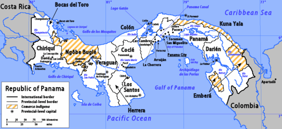
The border between North America and South America is at some point on the Isthmus of Panama. The most common demarcation in atlases and other sources follows the Darién Mountains watershed that divides along the Colombia–Panama border where the isthmus meets the South American continent (see Darién Gap). Virtually all atlases list Panama as a state falling entirely within North America and/or Central America.[36]
Islands
Often the Caribbean islands are considered part of North America, but Aruba, Bonaire, Curaçao (ABC islands), and Trinidad and Tobago lie on the continental shelf of South America. On the other hand, the Venezuelan Isla Aves and the Colombian San Andrés and Providencia lie on the North American shelf. Additionally, the adjacent Venezuelan islands of Nueva Esparta and the islands of the Venezuelan Federal Dependencies can be considered to be a part of the Caribbean instead of part of South America. The circumstance of these islands is akin to that of the ABC islands, as both the ABC islands and the Venezuelan islands are at an equivalent range from the Venezuelan mainland. Thus, these Venezuelan lands could consequently be placed in North America instead.
Asia and North America
The Bering Strait and Bering Sea separate the landmasses of Asia and North America, as well as forming the international boundary between Russia and the United States. This national and continental boundary separates the Diomede Islands in the Bering Strait, with Big Diomede in Russia and Little Diomede in the U.S. The Aleutian Islands are an island chain extending westward from the Alaskan Peninsula toward Russia's Komandorski Islands and Kamchatka Peninsula. Most of them are always associated with North America, except for the westernmost Near Islands group, which is on Asia's continental shelf beyond the North Aleutians Basin and on rare occasions could be associated with Asia, which could then allow the U.S. state of Alaska to be considered a transcontinental state.
St. Lawrence Island in the northern Bering Sea belongs to Alaska and may be associated with either continent but is almost always considered part of North America, as with the Rat Islands in the Aleutian chain. At their nearest points, Alaska and Russia are separated by only 4 kilometres (2.5 miles).
The Americas, Australia and Oceania
The Galápagos Islands and Malpelo Island in the eastern Pacific Ocean are possessions of Ecuador and Colombia, respectively, and associated with South America. The uninhabited French possession of Clipperton Island 1,000 kilometres (600 miles) off the Mexican coast is associated with North America.
Easter Island, also known by its endonym Rapa Nui, is a territory of Chile, and is considered to be in Oceania, though politically it is associated with South America. Similar to Easter Island, and just to the northeast of it, is the nearby uninhabited Salas y Gómez Islands of Chile, which is also considered to be in Oceania while associated with South America politically. Additionally, Chile has the Desventuradas Islands and the Juan Fernández Islands, both are located in the Eastern Pacific and to the East of Salas y Gómez and Easter Island. Akin to Clipperton, the Desventuradas Islands and the Juan Fernández Islands are nominally associated with South America.
The United States controls numerous territories in Oceania, including the state of Hawaii and the territories of Guam, the Northern Mariana Islands and American Samoa.
Asia and Australia

The Malay Archipelago is usually divided between Asia and Australia, most commonly along the anthropologic Melanesian line or Weber's Line. Indonesia controls the western half of New Guinea, geographically part of Australasia. The eastern half of the island is part of Papua New Guinea which is considered to be part of Oceania. Indonesia is commonly referred to as one of the Southeast Asian countries. East Timor, an independent state that was formerly a territory of Indonesia, which is geographically part of Asia, is classified by the United Nations as part of the "South-Eastern Asia" block. It is expected to join the Association of Southeast Asian Nations,[37] having been involved as an ASEAN Regional Forum member since independence, and has participated in the Southeast Asian Games since 2003. Occasionally, all of the Malay Archipelago is included in Oceania, although this is extremely rare, especially as most of the archipelago lies on the Asian continental shelf.
Japan possesses the Bonin Islands, also known as the Ogasawara Islands, which is a territory consisting of scattered island atolls located in the Pacific Ocean. These islands are located at some distance southeast of the main Japanese islands. Due to the location of this territory, and the tropical nature of the islands, these are sometimes considered to be a part of Oceania as well.
The Commonwealth of Australia includes island possessions in Oceania and islands closer to Indonesia than the Australian mainland.
Antarctica
Antarctica along with its outlying islands have no permanent population. All land claims south of 60°S latitude are held in abeyance by the Antarctic Treaty System.
Australia's Heard Island and McDonald Islands and the French Kerguelen Islands are located on the Kerguelen Plateau, on the Antarctic continental plate. The French Crozet Islands, Île Amsterdam, Île Saint-Paul, and the Norwegian Bouvet Island are also located on the Antarctic continental plate, and are not often associated with other continents.
The South Georgia and the South Sandwich Islands are closer to Antarctica than to any other continent. However, they are politically associated with the inhabited Falkland Islands, which are closer to South America. Furthermore, Argentina, a South American country, maintains its irredentist claims on the islands. The continental shelf boundary separates the two island groups.
The Prince Edward Islands are located between Africa and Antarctica, and are the territory of South Africa, an African country.
The Australian Macquarie Island and the New Zealand Antipodes Islands, Auckland Islands, and Campbell Islands, are all located between Australia and New Zealand and Antarctica.
See also
References
- "Archived copy". Archived from the original on 25 December 2012. Retrieved 15 October 2012.CS1 maint: archived copy as title (link); "Countries of Africa". Retrieved 14 June 2016.
- "African/Arabian Tectonic Plates". African/Arabian Tectonic Plates. Retrieved 6 October 2016.
- "African Plate". www.uwgb.edu. Archived from the original on 6 October 2016. Retrieved 6 October 2016.
- Hans Slomp (2011). Europe: A Political Profile. ISBN 9780313391828. Retrieved 10 September 2014.
- Histories 4.38. C.f. James Rennell, The Geographical System of Herodotus Examined and Explained, Volume 1, Rivington 1830, p. 244
- according to Strabo (Geographica 11.7.4) even at the time of Alexander, "it was agreed by all that the Tanais river separated Asia from Europe" (ὡμολόγητο ἐκ πάντων ὅτι διείργει τὴν Ἀσίαν ἀπὸ τῆς Εὐρώπης ὁ Τάναϊς ποταμός; c.f. Duane W. Roller, Eratosthenes' Geography, Princeton University Press, 2010, ISBN 978-0-691-14267-8, p. 57)
- W. Theiler, Posidonios. Die Fragmente, vol. 1. Berlin: De Gruyter, 1982, fragm. 47a.
- I. G. Kidd (ed.), Posidonius: The commentary, Cambridge University Press, 2004, ISBN 978-0-521-60443-7, p. 738.
- Geographia 7.5.6 (ed. Nobbe 1845, vol. 2, p. 178)) Καὶ τῇ Εὐρώπῃ δὲ συνάπτει διὰ τοῦ μεταξὺ αὐχένος τῆς τε Μαιώτιδος λίμνης καὶ τοῦ Σαρματικοῦ Ὠκεανοῦ ἐπὶ τῆς διαβάσεως τοῦ Τανάϊδος ποταμοῦ. "And [Asia] is connected to Europe by the land-strait between Lake Maiotis and the Sarmatian Ocean where the river Tanais crosses through."
- Philipp Johann von Strahlenberg (1730). Das Nord-und Ostliche Theil von Europa und Asia (in German). p. 106.
- "Boundary of Europe and Asia along Urals" (in Russian). Archived from the original on 17 April 2013.
- Peter Simon Pallas, Journey through various provinces of the Russian Empire, vol. 3 (1773)
- Douglas W. Freshfield, "Journey in the Caucasus", Proceedings of the Royal Geographical Society, Volumes 13-14, 1869. Cited as de facto convention by Baron von Haxthausen, Transcaucasia (1854); review Dublin University Magazine
- "Europe", Brockhaus and Efron Encyclopedic Dictionary, 1906
- "Do we live in Europe or in Asia?" (in Russian).
- Orlenok V. (1998). "Physical Geography" (in Russian). Archived from the original on 16 October 2011.
- E. M. Moores, R. W. Fairbridge, Encyclopedia of European and Asian regional geology, Springer, 1997, ISBN 978-0-412-74040-4, p. 34: "most Soviet geographers took the watershed of the Main Range of the Greater Caucasus as the boundary between Europe and Asia."
- National Geographic Atlas of the World (9th ed.). Washington, DC: National Geographic. 2011. ISBN 978-1-4262-0634-4. "Europe" (plate 59); "Asia" (plate 74): "A commonly accepted division between Asia and Europe ... is formed by the Ural Mountains, Ural River, Caspian Sea, Caucasus Mountains, and the Black Sea with its outlets, the Bosporus and Dardanelles."
- World Factbook. Washington, DC: Central Intelligence Agency.
- World Factbook. Washington, DC: Central Intelligence Agency. Azerbaijan: Geography and Georgia: Geography
- "Caucasus". Encyclopaedia Britannica. 2012.
- Thomas De Waal. The Caucasus: An Introduction. Oxford University Press, 2010. ISBN 0195399765, 9780195399769. p. 10
- World Factbook. Washington, D.C.: Central Intelligence Agency. Kazakhstan: Geography
- Klement Tockner; Urs Uehlinger; Christopher T. Robinson (2009). "18". Rivers of Europe (Illustrated ed.). Academic Press. ISBN 9780123694492.
- Glanville Price (2000). Encyclopedia of the Languages of Europe. Oxford, UK: Blackwell. p. xii.
- "Orenburg bridge monument photos".
- e.g. Encyclopædia Britannica Online (2011) s.v. "Kuma-Manych Depression": "It is often regarded as the natural boundary between Europe and Asia."
- "Composition of macro geographical (continental) regions, geographical sub-regions, and selected economic and other groupings". United Nations Statistics Division.
- "Standard country or area codes and geographical regions for statistical use". Unstats.un.org. Retrieved 5 June 2018.
- United Nations Industrial Organisation p. 14
- UNESCO, Europe and North America, Retrieved: 10 May 2016
- II General information, point 62 on Council of Europe document 11007 dated 7 July 2006 at "Archived copy". Archived from the original on 8 March 2013. Retrieved 12 February 2015.CS1 maint: archived copy as title (link)
- Clark, Miles. Russian Voyage. National Geographic Magazine, June 1994. p. 114 a 138.
- Purves, Libby (30 April 1993). "Obituary: Miles Clark". The Independent. London.
- See continent on Wiktionary. "from Latin continent-, continens 'continuous mass of land, mainland'" (http://www.merriam-webster.com/dictionary/continent?show=1&t=1301917145 merriam-webster.com])
- "National Geographic Education". National Geographic Society. Retrieved 12 May 2011.
National Geographic Atlas (list). National Geographic Society. 2010. p. 4.
Webster's New Geographical Dictionary (list and map). Merriam-Webster Inc. 1984. pp. 856, 859.
"Americas" Standard Country and Area Codes Classifications (M49), United Nations Statistics Division
"North America" Archived 3 March 2008 at the Wayback Machine Atlas of Canada
North America Atlas National Geographic - "East Timor ASEAN bid". The Sydney Morning Herald. 23 July 2006.
Continents of the world | ||||||
|---|---|---|---|---|---|---|
| ||||||
| ||||||
.svg.png)
.svg.png)
.svg.png)
.svg.png)
.svg.png)
_political.svg.png)
.svg.png)
.svg.png)
.svg.png)