Federal Dependencies of Venezuela
The Federal Dependencies of Venezuela (Spanish: Dependencias Federales de Venezuela) encompass most of Venezuela's offshore islands in the Caribbean Sea and the Gulf of Venezuela, excluding those islands that form the State of Nueva Esparta. These islands, with a total area of 342 square kilometres, are sparsely populated – according to the preliminary results of the 2011 Census only 2,155 people live there permanently, with another hundred from Margarita Island who live there seasonally to engage in fishing. Local government is officially under the authority of the mayor of Caracas, although de facto power is often held in the heads of the sparse and somewhat isolated communities that decorate the territories.[1][2][3][4]
Federal Dependencies of Venezuela | |
|---|---|
Dependencies | |
 Flag | |
.svg.png) Location in Venezuela | |
| Created | 2012 |
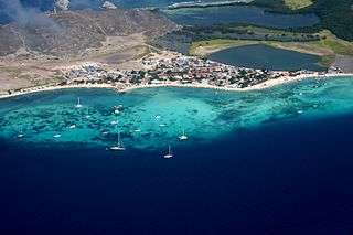
| Capital | Gran Roque |
| Islands and Groups | List
|
| Area | |
| • Total | 342 km2 (132 sq mi) |
| Population (2011 Census) | |
| • Total | 2,155 |
| Time zone | UTC-4:00 |
In 2015, a diplomatic problem occurred between Venezuela and Colombia due to the incursion of Colombian and US frigates.[5]
Geography
The federal dependencies are composed of 600 islands and smaller formations; many have an area of less than 10,000 square metres and are essentially simple rocks. The largest island, La Tortuga, accounts for almost half of the territory of the federal dependencies.
Dependencias Federales stretch for 900 km (560 mi) along the coast from Archipiélago Los Monjes in the west at the Gulf of Venezuela to Isla de Patos southeast of Isla Margarita at the Gulf of Paria in the east.

Biogeographical area
The World Geographical Scheme for Recording Plant Distributions groups the islands, excluding the abyssal Aves Island, into an area it calls the "Venezuelan Antilles" (Level 3 code "VNA").
Principal islands and archipelagos
These are set out below:
- Los Monjes Archipelago (Archipiélago Los Monjes)
- La Tortuga Island (Isla La Tortuga)
- La Sola Island (Isla La Sola)
- Los Testigos Islands (Islas Los Testigos)
- Los Frailes Islands (Islas los Frailes)
- Patos Island (Isla de Patos)
- Los Roques Archipelago (Archipiélago Los Roques)
- Blanquilla Island (Isla La Blanquilla)
- Los Hermanos Archipelago (Archipiélago Los Hermanos)
- Orchila Island (Isla La Orchila)
- Las Aves Archipelago (Archipiélago Las Aves)
- Aves Island (Isla de Aves)
.svg.png) Political Map Federal Administrative Agencies numbering based on the table of islands | |||||
| Nr. | Island or archipelago | Surface km2 |
Population 2011 Census (preliminary return) |
Members Islands | Coordinates |
| Within the Continental Shelf | |||||
| 1 | Los Monjes Archipelago | 0.20 | - | Monjes del Norte - Monje del Este - Monjes del Sur | 12°21′N 70°55′W |
| 2 | La Tortuga Island | 156.60 | - | Isla La Tortuga - Islas Los Tortuguillos - Cayo Herradura - Los Palanquines - Cayos de Ño Martín - Islote El Vapor - Cayos de Punta de Ranchos | 10°55′N 80°31′W |
| 3 | La Sola Island | 0.0005 | - | Isla La Sola | 11°18′N 63°34′W |
| 4 | Los Testigos Islands | 6,53 | 172 | Isla Conejo - Isla Iguana - Isla Morro Blanco - Isla Rajada - Isla Noroeste - Peñón de Fuera - Isla Testigo Grande | 11°22′N 63°06′W |
| 5 | Los Frailes Islands | 1.92 | - | Chepere - Guacaraida - Puerto Real - Nabobo - Cominoto - Macarare - Guairiare - Guacaraida - La Balandra - La Peche | 11°12′N 63°44′W |
| Outside of the Continental Shelf | |||||
| 6 | Patos Island (Este) | 0.60 | - | Isla de Patos Este | 10°38′N 61°52′W |
| 7 (Note A) | Los Roques Archipelago | 40.61 | 1,471 | Gran Roque - Cayo Francisquí - Isla Larga - Nordisquí - Madrisquí - Crasquí - Dos Mosquises - Cayo Sal - Cayo Nube Verde - Cayo Grande - Noronquí - Espenquí - Cayo Carenero - Cayo Selesquí - Cayo Bequevé - Cayo de Agua - Cayo Grande | 11°51′N 66°45′W |
| 8 | Blanquilla Island | 64.53 | - | Isla La Blanquilla | 11°50′N 64°35′W |
| 9 | Los Hermanos Archipelago | 2.14 | - | La Orquilla - Isla Los Morochos - Isla Grueso - Isla Pico (ó Isla Pando) - Isla Fondeadero - Isla Chiquito | 11°45′N 64°25′W |
| 10 (Note A) | Orchila Island | 40.00 | - | Isla La Orchila - Cayo Agua - Cayo Sal - Cayo Noreste | 11°47′N 66°10′W |
| 11 (Note A) | Las Aves Archipelago | 3.35 | - | Isla Aves de Barlovento - Isla Tesoro - Cayo Bubi - Cayo de Las Bobas - Isla Aves de Sotavento - Isla Larga - Cayo Tirra - Isla Saquisaqui - Cayos de La Colonia - Isla Maceta - Cayo Sterna | 12°00′N 67°40′W |
| Abyssal | |||||
| 12 | Aves Island (Norte) | 0.045 | - | Isla de Aves | 15°40′N 67°37′W |
| Federal Dependencies of Venezuela | 342.25 | 2,155 | |||
- Note A: within the Dependencias Federales, the Archipiélago Los Roques, the Archipiélago Las Aves and the Isla La Orchila together comprise the Territorio Insular Francisco de Miranda, which was established on November 10, 2011.[6]
See also
References
- Vila, Marco Aurelio. 1967: Aspectos geográficos de las Dependencias Federales. Corporación Venezolana de Fomento. Caracas. 115p.
- República de Venezuela y República Dominicana. 1981: Tratado de relimitación de áreas marinas y submarinas entre la República de Venezuela y República Dominicana. Ministerio de la Defensa. Caracas. 8p.
- Cervigon, Fernando. 1995: Las Dependencias Federales. Academia Nacional de la Historia. Caracas. 193p.
- Hernández Caballero, Serafín (Editor). 1998: Gran Enciclopedia de Venezuela. Editorial Globe, C.A. Caracas. 10 volúmenes. ISBN 980-6427-00-9 ISBN 980-6427-10-6
- Redacción El Tiempo. "Revive la tensión limítrofe entre Colombia y Venezuela". 20 june 2015. El Tiempo. Retrieved 20 September 2019.
- "El Territorio Insular Francisco de Miranda". Archived from the original on 2014-04-14. Retrieved 2014-04-13.
External links
| Wikimedia Commons has media related to Federal dependencies of Venezuela. |
- Territorio Insular
- Los Roques Comunidad
- Map of the Dependencias Federales
- Cost of living for Dependencias Federales
| Capital District | ||
|---|---|---|
| States | ||
| Federal Dependencies |
| |
| Regions | ||
| Claimed | ||