Turkish Straits
The Turkish Straits (Turkish: Türk Boğazları) are two internationally significant waterways in northwestern Turkey. The straits create a series of international passages that connect the Aegean and Mediterranean seas to the Black Sea. They consist of the Dardanelles and the Bosphorus. The straits are on opposite ends of the Sea of Marmara. The straits and the Sea of Marmara are part of the sovereign sea territory of Turkey and subject to the regime of internal waters.
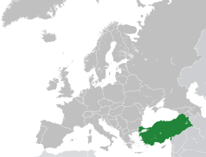

Located in the western part of the landmass of Eurasia, the Turkish Straits are conventionally considered the boundary between the continents of Europe and Asia, as well as the dividing line between European Turkey and Asian Turkey. Owing to their strategic importance in international commerce, politics, and warfare, the Turkish Straits have played a significant role in European and world history. Since 1936, they have been governed in accordance with the Montreux Convention.
Geography
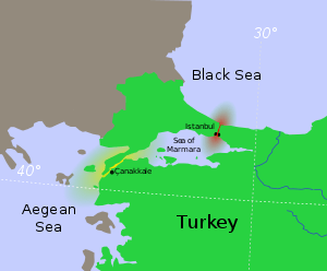
As maritime waterways, the Turkish Straits connect various seas along the Eastern Mediterranean, the Balkans, the Near East, and Western Eurasia. Specifically, the Straits allows maritime connections from the Black Sea all the way to the Aegean and Mediterranean Seas, the Atlantic Ocean via Gibraltar, and the Indian Ocean through the Suez Canal, making them crucial international waterways, in particular for the passage of goods coming in from Russia.
The Turkish Straits are made up of the following waterways;
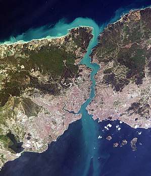
- The Bosphorus (also spelled Bosporus; Turkish: Boğaziçi or İstanbul Boğazı, "Istanbul Strait"), about 30 kilometers (19 mi) long and only 700 meters (2,300 ft) wide, connects the Sea of Marmara with the Black Sea in the north. It runs through the city of Istanbul, making it a city located on two continents. It is crossed by three suspension bridges (the Bosphorus Bridge, the Fatih Sultan Mehmet Bridge and the Yavuz Sultan Selim Bridge), and two underwater tunnels (the Marmaray rail tunnel and the Eurasia road tunnel). There are plans for further crossings being debated at various stages.
- The Dardanelles (Turkish: Çanakkale Boğazı, "Çanakkale Strait"), 68 km (42 mi) long and 1.2 km (0.75 mi) wide, connects the Sea of Marmara with the Mediterranean in the southwest, near the city of Çanakkale. In classical antiquity, the Dardanelles strait was known as the Hellespont. The strait and the Gallipoli (Gelibolu) peninsula on its western shoreline were the scene of the Battle of Gallipoli during the First World War. Currently, there are no crossings across the strait, but plans have been offered in recent years for a suspension bridge project as part of proposed expansions to the national highway network.
Developments of economic activities threaten marine ecosystem including endemic dolphins and harbour porpoises.[1]
Straits Question
The Straits have been of urgent maritime strategic importance since the Trojan War was fought near the Aegean entrance. In the declining days of the Ottoman Empire the "Straits Question" involved the diplomats of Europe and the Ottoman Empire.
By the terms of the London Straits Convention concluded on July 13, 1841, between the Great Powers of Europe—Russia, the United Kingdom, France, Austria and Prussia—the "ancient rule" of the Ottoman Empire was re-established by closing the Turkish straits to all warships whatsoever, barring those of the sultan's allies during wartime.[2]
The treaty is one in a series dealing with access to the Bosphorus, the Sea of Marmara, and the Dardanelles. It evolved from the secret 1833 Treaty of Hünkâr İskelesi (Unkiar Skelessi), in which the Ottoman Empire guaranteed exclusive use of the Straits to "Black Sea Powers" (i.e., Ottoman Empire and Russian Empire) warships in the case of a general war.
The modern treaty controlling relations is the 1936 Montreux Convention Regarding the Regime of the Turkish Straits, which is still in force. It gives the Republic of Turkey control over warships entering the straits but guarantees the free passage of civilian vessels in peacetime.
References
- Khan S.. 2013. An Economic Boom in Turkey Takes a Toll on Marine Life. Yale Environment 360. Retrieved on September 06, 2017
- Rozakis & Stagos 1987, pp. 24–25.
Sources
- Gerolymatos, André (2014). "The Turkish Straits: History, Politics and Strategic Dilemmas". Ocean Yearbook. 28: 58–79. doi:10.1163/22116001-02801003.CS1 maint: ref=harv (link)
- Rozakis, Christos L.; Stagos, Petros N. (1987). The Turkish Straits. Martinus Nijhoff Publishers. ISBN 90-247-3464-9.CS1 maint: ref=harv (link)