Borough of Swindon
The Borough of Swindon is a local government authority in South West England, centred on the town of Swindon and forming part of the ceremonial county of Wiltshire.
Borough of Swindon | |
|---|---|
 | |
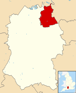 Shown within Wiltshire | |
| Coordinates: 51°33′47″N 1°45′47″W | |
| Sovereign state | United Kingdom |
| Constituent country | England |
| Region | South West England |
| Ceremonial county | Wiltshire |
| Status | Unitary authority |
| Admin HQ | Swindon |
| Government | |
| • Type | Unitary authority |
| • Body | Swindon Borough Council |
| • Leadership | Leader & Cabinet (Conservative) |
| • MPs | Robert Buckland (C) Justin Tomlinson (C) |
| Area | |
| • Total | 88.84 sq mi (230.10 km2) |
| Area rank | 152nd (of 317) |
| Population (mid-2019 est.) | |
| • Total | 222,193 |
| • Rank | 78th (of 317) |
| • Density | 2,500/sq mi (970/km2) |
| • Ethnicity | 85.6% White British 5.4% Other White 3.9% Asian 1.71% Black British 2.0% Mixed Race 0.6% Other [1] |
| Time zone | UTC0 (GMT) |
| • Summer (DST) | UTC+1 (BST) |
| ONS code | 00HX (ONS) E06000030 (GSS) |
| OS grid reference | SU164849 |
| Website | www |
History
In 1974 the Thamesdown district of Wiltshire was created from the areas of the municipal borough of Swindon (created 1900) and Highworth Rural District (created 1894). On 1 April 1997 it was made administratively independent of Wiltshire County Council, and its council became a unitary authority.[2] The council adopted the name Swindon on 24 April 1997. The former Thamesdown name and logo continued to be used by the municipal bus operator, Thamesdown Transport, until 2017 when it was sold and renamed to "Swindon's Bus Company".[3]
Geography
The borough of Swindon occupies an area forming the north east corner of Wiltshire and is bordered by two other counties, Gloucestershire (to the north) and Oxfordshire (to the east). West Berkshire is also only a short distance from the borough's south eastern tip. The generally hilly landscape is sculpted by the upper Thames guiding the northern border, small tributaries draining into the Thames, and the Marlborough Downs rising toward the south.
The borough encompasses the Swindon urban area and surrounding countryside to the north, east and south, including the town of Highworth. It comprises the former Swindon Municipal Borough and a further 18 civil parishes:[4][5]
- Bishopstone (with Hinton Parva)
- Blunsdon
- Castle Eaton
- Chiseldon
- Covingham
- Hannington
- Haydon Wick
- Highworth (town and surrounding district)
- Inglesham
- Liddington
- Nythe, Eldene and Liden
- St Andrews
- South Marston
- Stanton Fitzwarren
- Stratton St Margaret
- Wanborough
- West Swindon
- Wroughton
Since 1 April 2017 the entire Borough has been parished, following the establishment of West Swindon parish and the creation of Central Swindon North and Central Swindon South[5] (styled by its parish council as South Swindon).[6][7] The two Central parishes fall within the boundaries of the town and former municipal borough, the Great Western main line railway forming the boundary between them.
At the same time:
- the part of Chiseldon parish north of the M4, including the former hamlet of Coate, was transferred to Central Swindon South;
- the parish of Blunsdon St Andrew was divided into St Andrews and Blunsdon, the A419 forming the boundary between them;
- the parish of Nythe was expanded to form Nythe, Eldene and Liden.
Economy
This is a chart of trend of regional gross value added of Swindon at current basic prices published (pp. 240–253) by Office for National Statistics with figures in millions of British Pounds Sterling.
| Year | Regional Gross Value Added | Agriculture | Industry | Services |
|---|---|---|---|---|
| 1995 | 2,654 | 13 | 1,023 | 1,618 |
| 2000 | 4,085 | 9 | 1,368 | 2,708 |
| 2003 | 4,259 | 8 | 1,185 | 3,067 |
^ includes hunting and forestry
^ includes energy and construction
^ includes Financial Intermediation Services Indirectly Measured
^ Components may not sum to totals due to rounding
Swindon Borough Council
The council follows a leader and cabinet model[8] and has 57 elected members. Elections are held in three out of every four years, with one third of the seats being elected at each election. From the first election in 1996 to the 2000 election, Labour had a majority on the council. Following a period where no party had a majority the Conservatives gained a majority at the 2003 election and have held control since then. As of the 2016 local elections, the council is composed of the following councillors:-[9]
| Party | Councillors | |
| Conservative Party | 30 | |
| Labour Party | 25 | |
| Liberal Democrats | 2 | |
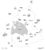
Wards
The following are the electoral wards within the Borough as at 2016.[10]
- Blunsdon & Highworth [3 Conservative Cllrs]
- Central [3 Labour Cllrs]
- Chiseldon & Lawn [2 Conservative Cllrs]
- Covingham and Dorcan [3 Conservative Cllrs]
- Eastcott [2 Lib Dem & 1 Labour Cllr]
- Gorse Hill and Pinehurst [3 Labour Cllrs]
- Haydon Wick [3 Conservative Cllrs]
- Liden, Eldene & Park South [3 Labour Cllrs]
- Lydiard & Freshbrook [2 Conservative Cllrs & 1 Labour Councillor]
- Mannington & Western [3 Labour Cllrs]
- Old Town [1 Conservative & 2 Labour Cllrs]
- Penhill & Upper Stratton [3 Labour Cllrs]
- Priory Vale [3 Conservative Cllrs]
- Ridgeway [1 Conservative Cllr]
- Rodbourne Cheney [3 Labour Cllrs]
- Shaw [3 Conservative Cllrs]
- St Andrews [3 Conservative Cllrs]
- St Margaret & South Marston [3 Conservative Cllrs]
- Walcot & Park North [3 Labour Cllrs]
- Wroughton and Wichelstowe [3 Conservative Cllrs]
Other elections
For electoral purposes, the borough is divided into two Parliamentary constituencies: North Swindon and South Swindon. Both constituencies are seen as key marginal seats at general elections, with both having been bellwether seats since 1997 when they were created. Currently both seats are held by the Conservative Party.
The borough was one of the first areas to declare in the 2016 European Union membership referendum. 61,745 (54.3%) voters supported leaving the European Union, whilst 51,220 (45.7%) wished to remain. Psephologist Chris Hanretty has estimated that 57.3% of voters in North Swindon supported leave, compared to 51.7% in South Swindon.
For the purposes of elections to the European Parliament, Swindon lies in the South West region, and is represented by 3 Brexit Party MEPs, 2 Liberal Democrat MEPs, and one Green MEP. In 2019, 35.7% of the borough's voters backed the Brexit Party, 17.8% backed the Liberal Democrats, and 14.6% backed Labour.
References
- https://www.theguardian.com/news/datablog/interactive/2011/may/19/ethnic-breakdown-england-wales
- The Wiltshire (Borough of Thamesdown)(Structural Change) Order 1995
- "Thamesdown Transport". Archived from the original on 5 February 2017.
- "Community governance review - next steps". www.swindon.gov.uk. Swindon Borough Council. March 2017. Archived from the original on 6 April 2017.
- "The Swindon Borough (Reorganisation of Community Governance) No. 1 Order 2017" (PDF). Local Government Boundary Commission for England. 19 January 2017. p. 4. Archived from the original (PDF) on 25 January 2018.
- "South Swindon Parish Council". www.southswindon-pc.gov.uk. Retrieved 14 September 2018.
- Seaward, Tom (1 November 2017). "South Swindon Parish Council responds to name change block". Swindon Advertiser. Retrieved 14 September 2018.
- "Archived copy". Archived from the original on 7 September 2007. Retrieved 2010-02-02.CS1 maint: archived copy as title (link)
- "England council elections". BBC News Online. Retrieved 11 September 2011.
- "Councillors by Ward". Swindon Borough Council. Retrieved 3 June 2016.
England Portal | |
| Unitary authorities | |
| Major settlements | |
| Rivers | |
| Topics | |