River Till, Wiltshire
The River Till is a river that rises near Tilshead on Salisbury Plain, and which flows south and south-east to join the River Wylye near Stapleford. It also flows through Shrewton and Winterbourne Stoke. It has been designated as a SSSI site.
| River Till | |
|---|---|
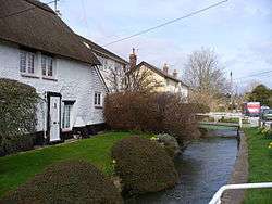 River Till at Shrewton | |
| Location | |
| Country | United Kingdom |
| Country within the UK | England |
| Counties | Wiltshire |
| Physical characteristics | |
| Source | |
| ⁃ location | Tilshead, Salisbury |
| ⁃ coordinates | 51°13′49″N 1°57′21″W |
| Mouth | |
⁃ location | Stapleford, Wiltshire |
⁃ coordinates | 51°08′09″N 1°54′07″W |
The name ‘River Till’ is a double misnomer, firstly because this is not a river but a winterbourne – i.e. a winter stream that only flows for approximately three months in a year. Secondly because the name ‘Till’ is a Victorian misunderstanding. At some point the false leap of logic was made that because the winterbourne flows from the village of Tilshead this meant it was the head of the Till. In fact Tilshead arises from Tydolfshide, i.e. the hide of land belonging to Tydolf.
Even as recently as the early 20th century the winterbourne was known, in Shrewton at least, as ‘the Waterlake’, rather than the Till.
England Portal | |
| Unitary authorities | |
| Major settlements | |
| Rivers | |
| Topics | |