Bingöl
Bingöl (Zazaki: Çolig,[3] Kurdish: Çewlik[4]) is a city in Eastern Turkey. It is surrounded by mountains and numerous glacier lakes, hence the name (Turkish for a thousand lakes). Lately, the town has become a popular tourist destination. According to 2017 estimates, it has a population of over 111,000.[5]
Bingöl | |
|---|---|
 Bingöl | |
| Coordinates: 38°53′10″N 40°30′6″E | |
| Country | Turkey |
| Province | Bingöl |
| Government | |
| • Mayor | Yücel Barakazi (AKP) |
| Area | |
| • District | 1,789.86 km2 (691.07 sq mi) |
| Elevation | 1,120 m (3,690 ft) |
| Population (2012)[2] | |
| • Urban | 98,424 |
| • District | 142,455 |
| • District density | 80/km2 (210/sq mi) |
| Website | www |
Bingöl is the capital of Bingöl Province, one of the 81 provinces of Turkey.
History
In the Middle Ages, Bingöl was known as Romanoupolis (Greek: Ῥωμανούπολις) after the Byzantine emperor Romanos I Lekapenos, who incorporated it permanently into the Byzantine Empire in 942. It initially formed a subdivision of the thema of Mesopotamia, but it was later (ca. 970) elevated into a separate theme.[6].
Bingol was ruled by the Kurdish Suveydi Dynasty from 13 centuries to 1864, which ruled the Bingöl region autonomously subject to the Ottoman's in 1514[7].Until the middle of the 20th century, the city was known as Çapakçur/Çabakçur, according to its Armenian name of Chapaghjur ("rough waters").[8][9] The place was then renamed Bingöl, a term of Turkish origin translating as "thousand lakes". On 1 May 2003 the whole area suffered from a magnitude 6.4 earthquake, leaving 176 dead and 520 injured.[10] On 8 March 2010, the area suffered another earthquake, of magnitude 5.9, with its epicenter in Elâzığ Province, 45 km (28 mi) west of Bingöl.
Geography
Bingöl is 144 kilometres (89 mi) east of Elâzığ and is situated in the high region of Eastern Anatolia. Bingöl is a mountainous area with heights reaching 3000m, Bingöl city is at about 1120m above sea level.[11] The Gayt River (Gayt Çayı), a right-bank tributary of the Eastern Euphrates (Murat River), runs through the city.
Climate
Bingöl has a continental climate (Köppen climate classification: Dsa), with hot and dry summers and cold and snowy winters. The driest months are July and August and the wettest are February and December.
| Climate data for Bingöl (1960–2012) | |||||||||||||
|---|---|---|---|---|---|---|---|---|---|---|---|---|---|
| Month | Jan | Feb | Mar | Apr | May | Jun | Jul | Aug | Sep | Oct | Nov | Dec | Year |
| Record high °C (°F) | 13.3 (55.9) |
16.2 (61.2) |
22.3 (72.1) |
30.3 (86.5) |
33.4 (92.1) |
39.0 (102.2) |
42.0 (107.6) |
41.3 (106.3) |
37.8 (100.0) |
32.1 (89.8) |
25.5 (77.9) |
22.8 (73.0) |
42.0 (107.6) |
| Average high °C (°F) | 2.1 (35.8) |
3.3 (37.9) |
9.1 (48.4) |
16.2 (61.2) |
22.7 (72.9) |
29.3 (84.7) |
34.5 (94.1) |
34.5 (94.1) |
29.7 (85.5) |
21.5 (70.7) |
12.4 (54.3) |
4.9 (40.8) |
18.3 (65.0) |
| Daily mean °C (°F) | −2.5 (27.5) |
−1.5 (29.3) |
3.8 (38.8) |
10.6 (51.1) |
16.3 (61.3) |
22.1 (71.8) |
26.7 (80.1) |
26.4 (79.5) |
21.1 (70.0) |
14.0 (57.2) |
6.6 (43.9) |
0.5 (32.9) |
12.0 (53.6) |
| Average low °C (°F) | −6.1 (21.0) |
−5.4 (22.3) |
−0.5 (31.1) |
5.6 (42.1) |
10.1 (50.2) |
14.6 (58.3) |
18.9 (66.0) |
18.5 (65.3) |
13.5 (56.3) |
8.1 (46.6) |
2.1 (35.8) |
−2.9 (26.8) |
6.4 (43.5) |
| Record low °C (°F) | −23.2 (−9.8) |
−21.6 (−6.9) |
−20.3 (−4.5) |
−9.2 (15.4) |
1.0 (33.8) |
3.5 (38.3) |
8.8 (47.8) |
7.8 (46.0) |
4.2 (39.6) |
−2.4 (27.7) |
−15.0 (5.0) |
−25.1 (−13.2) |
−25.1 (−13.2) |
| Average precipitation mm (inches) | 132.6 (5.22) |
133.5 (5.26) |
127.4 (5.02) |
122.2 (4.81) |
75.3 (2.96) |
20.8 (0.82) |
5.8 (0.23) |
3.4 (0.13) |
10.2 (0.40) |
64.2 (2.53) |
110.8 (4.36) |
136.1 (5.36) |
942.3 (37.1) |
| Average precipitation days | 12.6 | 12.4 | 13.5 | 15.2 | 13.5 | 5.5 | 1.8 | 1.4 | 2.4 | 8.3 | 9.3 | 12.7 | 108.6 |
| Mean monthly sunshine hours | 105.4 | 123.2 | 155 | 168 | 238.7 | 291 | 310 | 294.5 | 258 | 195.3 | 135 | 93 | 2,367.1 |
| Source: Devlet Meteoroloji İşleri Genel Müdürlüğü [12] | |||||||||||||
Transport
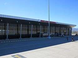
Bingöl Airport opened on 12 July 2013.
Education
Bingöl University opened on 29 May 2007.[13]
References
- "Area of regions (including lakes), km²". Regional Statistics Database. Turkish Statistical Institute. 2002. Retrieved 5 March 2013.
- "Population of province/district centers and towns/villages by districts - 2012". Address Based Population Registration System (ABPRS) Database. Turkish Statistical Institute. Retrieved 27 February 2013.
- Abdurrahman Yılmaz (2015). "Zazaca - Türkçe sözlük : Genç - Bingöl yöresi" (PDF) (in Zazaki and Turkish): 32. Retrieved 29 April 2020. Cite journal requires
|journal=(help) - Adem Avcıkıran (2009). Kürtçe Anamnez Anamneza bi Kurmancî (PDF) (in Turkish and Kurdish). p. 55. Retrieved 17 December 2019.
- Statistical Institute
- Oikonomides, Nicolas (1972). Les Listes de Préséance Byzantines des IXe et Xe Siècles (in French). Paris, France: Editions du Centre National de la Recherche Scientifique. p. 359.
- M. Mahfuz, Söylemez (2010). According To The Tahrir Register Dated 1550 Liva Of Çapakçur (PDF). Bingöl. p. 17. ISBN 978-975-6788-82-0.
- Italian City-states and Catholic Missions in Mongolian World of the 13th and 14th Centuries, ANTHROPOLOGIA INTEGRA Vol. 3, No. 2, 2012, p.9; academia.edu
- Bingöl Tarihi, frmartuklu.org
- Aydan, Ö. (July 2003). "THE BİNGÖL EARTHQUAKE OF MAY 1, 2003" (PDF). Tokai University, Department of Marine Civil Engineering. p. 1.
- Aydan, Ö. (July 2003). "THE BİNGÖL EARTHQUAKE OF MAY 1, 2003" (PDF). Tokai University, Department of Marine Civil Engineering. p. 4.
- "Archived copy". Archived from the original on 30 April 2011. Retrieved 2011-03-19.CS1 maint: archived copy as title (link)
- Bingöl University Archived 11 June 2015 at the Wayback Machine
Bingöl in Bingöl Province of Turkey | |||||||||||||||||||||||||||
|---|---|---|---|---|---|---|---|---|---|---|---|---|---|---|---|---|---|---|---|---|---|---|---|---|---|---|---|
| Districts | 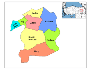 Districts of Bingöl | ||||||||||||||||||||||||||
| |||||||||||||||||||||||||||
Metropolitan municipalities are bolded. | |||||||||||||||||||||||||||
| Authority control |
|
|---|