Avanos
Avanos (Greek: Άβανος (f. sg.)) is a town and district of Nevşehir Province in the Central Anatolia region of Turkey, located 18 km (11 mi) north of Nevşehir, the capital city of the province. It is situated within the historic and tourist region of Cappadocia. According to 2000 census, population of the district is 35,145 of which 12,288 live in the town of Avanos.[3][4] The district covers an area of 994 km2 (384 sq mi),[5] and the average elevation is 920 m (3,018 ft), with the highest point being Mt. İsmail Sivrisi at 1,756 m (5,761 ft).
Avanos, Nevşehir, Türkiye | |
|---|---|
District | |
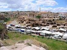
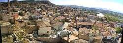 A panorama of Avanos | |
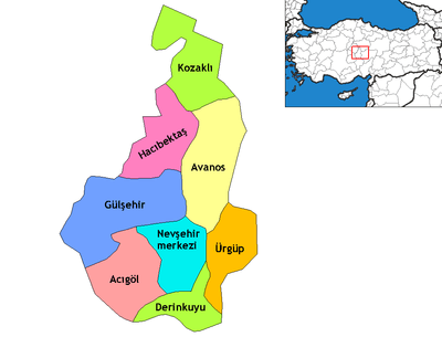 Location of Avanos within Nevşehir Province | |
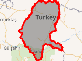
Map of Avanos | |
 Avanos, Nevşehir, Türkiye Location of Avanos within Nevşehir Province | |
| Coordinates: 38°43′N 34°51′E | |
| Country | |
| Region | Central Anatolia |
| Province | Nevşehir |
| Government | |
| • Governor | Aylin Kırcı Duman |
| • Mayor | İsmet İnce (CHP) |
| Area | |
| • District | 993.54 km2 (383.61 sq mi) |
| Elevation | 920 m (3,020 ft) |
| Population (2012)[2] | |
| • Urban | 13,210 |
| • District | 34,475 |
| • District density | 35/km2 (90/sq mi) |
| Time zone | UTC+2 (EET) |
| • Summer (DST) | UTC+3 (EEST) |
| Postal code | 50500 |
| Area code(s) | 0384 511 |
| Licence plate | 50 |
| Climate | Csb |
| Website | www.avanos.gov.tr |
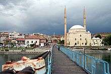
The old city of Avanos, whose name in ancient times was Venessa, overlooks the longest river of Turkey, the Kızılırmak (Red River), which also separates Avanos from the rest of Cappadocia.
The most famous historical feature of Avanos, which is still relevant and very visible today, is its production of earthenware pottery; it is also the most economic activity in the town. The ceramic trade in this district and its countless pottery factories date right back to the Hittites, and the ceramic clay from the red silt of the Kızılırmak has always been used. It is a popular destination because of its attractive old town with cobbled streets, and views over the river.
Climate
Summers are hot and dry, while winters are cold and wet.
Visitor attractions
About 5 km (3 mi) from Avanos and 1 km (1 mi) from Paşabağları, the site of Zelve was founded on the steep northern slopes of Aktepe. Consisting of three separate valleys, the ruins of Zelve is the area in Cappadocia with the highest concentration of fairy chimneys. Here, they have particularly sharp points and thick trunks. It is not known exactly when people began living in the dwellings carved into the rock, a lifestyle also common to other places in the region such as Uçhisar, Göreme, Cavuşin other than Zelve. What is known is that an important Christian community lived in Zelve and it was the religious center of the area from the 9th to the 13th centuries, and the first religious seminars for priests were held in the vicinity.
- Çavuşin (Nicephorus Phocas) Church
This church is located alongside Göreme-Avanos road at a distance of 2.5 km (1.6 mi) leaving from Göreme. The church's narthex is missing. It has tunnel vaults, a high nave and 3 apses. It dates back to 964-965 AD.
- Güllüdere (St. Agathangelus) Church
It is located in the far left draw of the Güllüdere valley about 2 km (1 mi) from the village of Çavuşin. It was founded at the mouth of the draw on top of a steep slope.
The design of the nave is square with a flat ceiling and it has a single broad apse. The apse was added in the 9th or 10th century to the main structure dating back to the 6th - 7th century. There are 2 or 3 layers of frescoes in the apse which indicates that it was painted regularly. Symbols of Gospel authors are drawn symmetrically and are sitting on the right and left of an enthroned Jesus.
In the middle of the flat ceiling is the relief of a cross in the middle of a circle surrounded with palm leaves and garlands. This sort of relief most likely belongs to the Iconoclastic period. The people of the area had a great love for the cross and it continued to be used as a motif after the Iconoclastic era because it symbolized the "Holy Cross" in Jerusalem.
Located 14 km (9 mi) northeast of Avanos, this underground city was built on the northern slopes of Mt. Idis in an area with lots of strata made up of volcanic granite. The extensive galleries of the city are spread out over a large area and connected to each another by tunnels. Unlike the underground cities in Kaymaklı and Derinkuyu, there are very narrow (5 cm) and long holes between the different levels of the city that used to provide communication between the different levels of the city. The ventilation of these neatly carved out rooms was provided by these holes when the city was sealed up against enemies.
The city was discovered in 1972 by the local muezzin and farmer Latif Acar, when trying to find out where the water disappeared to when tending to his crops. He first found an underground room which, when later excavated, revealed a whole city which housed an incredible 60,000 people for up to three months. A total of 10 floors were discovered, to a depth 40m, although now only four are open.
Unlike the other underground cities in this area, besides the rolling stone doors, there were holes above the tunnels used for dumping hot oil on the enemy. Similar to Kaymaklı and Derinkuyu, Özkonak has a ventilation system, a water well, a winery and rolling stone doors.
See also
Notes
- "Area of regions (including lakes), km²". Regional Statistics Database. Turkish Statistical Institute. 2002. Retrieved 2013-03-05.
- "Population of province/district centers and towns/villages by districts - 2012". Address Based Population Registration System (ABPRS) Database. Turkish Statistical Institute. Retrieved 2013-02-27.
- Statistical Institute
- GeoHive. "Statistical information on Turkey's administrative units". Retrieved 2008-04-13.
- Statoids. "Statistical information on districts of Turkey". Retrieved 2008-04-13.
References
- Falling Rain Genomics, Inc. "Geographical information on Avanos, Turkey". Retrieved 2008-04-12.
- Governorship of Avanos, Turkey. "General information on Avanos, Nevşehir" (in Turkish). Archived from the original on 2008-04-22. Retrieved 2008-04-12.
External links
| Wikimedia Commons has media related to Avanos. |
- District governor's official website (in Turkish)
- District municipality's official website (in Turkish)
- Maps of Avanos (in English)
- Zelve with pictures and information (in English)
- Hundreds of pictures of Avanos
- Travel Information for Avanos
- Information about Pottery and the Hair Museum of Avanos
Avanos in Nevşehir Province of Turkey | |||||||||||||||||||||||||||
|---|---|---|---|---|---|---|---|---|---|---|---|---|---|---|---|---|---|---|---|---|---|---|---|---|---|---|---|
| Districts | Districts of Nevşehir | ||||||||||||||||||||||||||
| |||||||||||||||||||||||||||
Metropolitan municipalities are bolded. | |||||||||||||||||||||||||||