Ürgüp
Ürgüp (Greek: Προκόπιο Prokópio,[3] or Cappadocian Greek: Προκόπι Prokópi, Ottoman Turkish: Burgut Kalesi) is a town and district of Nevşehir Province in the Central Anatolia region of Turkey. It is located in the historical region of Cappadocia, and near the cave Churches of Göreme. According to 2010 census, the population of the district is 34,372 of which 18,631 live in the town of Ürgüp.[4][5] The district covers an area of 563 km2 (217 sq mi),[6] and the town lies at an average elevation of 1,043 m (3,422 ft).
Ürgüp | |
|---|---|
District | |
 Hotels built within caves in Ürgüp | |
 Nearby Fairy Chimneys | |

Map of Ürgüp | |
 Ürgüp Location of Ürgüp within Turkey | |
| Coordinates: 38°37′53″N 34°54′47″E | |
| Country | |
| Region | Central Anatolia |
| Province | Nevşehir |
| Government | |
| • Governor | Recep Soytürk |
| • Mayor | Fahri Yıldız (AKP) |
| Area | |
| • District | 562.85 km2 (217.32 sq mi) |
| Elevation | 1,043 m (3,422 ft) |
| Population (2012)[2] | |
| • Urban | 19,116 |
| • District | 35,000 |
| • District density | 62/km2 (160/sq mi) |
| Time zone | UTC+2 (EET) |
| • Summer (DST) | UTC+3 (EEST) |
| Postal code | 50xxx |
| Area code(s) | 0384 |
| Vehicle registration | 50 |
| Climate | Csb |
| Website | www |
Cappadocia is one of Turkey's largest wine-producing regions, with Urgup as its capital. Uphill from Hotel Surban, the renowned Turasan Winery supplies 60% of Cappadocia's wines and offers free tours and tastings in its rock-carved wine cellar.[7]
According to the Ottoman General Census of 1881/82–1893, the kaza of Ürgüp had a total population of 23,030, consisting of 19,880 Muslims, 3,134 Greeks and 16 Armenians.[8]
Notable natives
- Saint John the Russian (1690-1730), Saint of the Greek Orthodox Church
- Mustafa Güzelgöz (1921–2005), librarian known as the "Librarian with Donkey"
International relations
See also
- Cappadocia
- Churches of Göreme, Turkey
- Kayakapı
- Kaymaklı Underground City
- Derinkuyu Underground City
- Underground cities in Avanos
- Thermal Tourism in Kozaklı
Notes
- "Area of regions (including lakes), km²". Regional Statistics Database. Turkish Statistical Institute. 2002. Retrieved 2013-03-05.
- "Population of province/district centers and towns/villages by districts - 2012". Address Based Population Registration System (ABPRS) Database. Turkish Statistical Institute. Retrieved 2013-02-27.
- Rodley, Lyn (2010). Cave Monasteries of Byzantine Cappadocia. Cambridge University Press. p. 5. ISBN 978-0-521-15477-2.
..medieval place names in the region that can be established are known only from scant references: one Elpidios, Memorophylax of Prokopios, who attended the Council of Chalcedon (451), may have come from Hagios Prokopios (now Urgup, but still called ‘Prokopion’ by the local Greek population in the early years of this century)
- Statistical Institute
- GeoHive. "Statistical information on Turkey's administrative units". Archived from the original on 2007-10-19. Retrieved 2008-04-18.
- Statoids. "Statistical information on districts of Turkey". Retrieved 2008-04-19.
- https://premiumtravel.net/turkey-cities/urgup/
- Kemal Karpat (1985), Ottoman Population, 1830-1914, Demographic and Social Characteristics, The University of Wisconsin Press, p. 142–143
- "Twinnings" (PDF). Central Union of Municipalities & Communities of Greece. Retrieved 2013-08-25.
References
- Falling Rain Genomics, Inc. "Geographical information on Ürgüp, Turkey". Retrieved 2008-04-18.
- Governorship of Ürgüp, Turkey. "Geography and history of Ürgüp, Nevşehir" (in Turkish). Retrieved 2008-04-18.
External links
| Wikimedia Commons has media related to Ürgüp. |
| Wikivoyage has a travel guide for Ürgüp. |
- District governor's official website (in Turkish)
- District municipality's official website (in Turkish)
- Map of Ürgüp district
- St George and the dragon
- Administrative map of Ürgüp district
- Hundreds of pictures of Ürgüp
Ürgüp in Nevşehir Province of Turkey | |||||||||||||||||||||||||||
|---|---|---|---|---|---|---|---|---|---|---|---|---|---|---|---|---|---|---|---|---|---|---|---|---|---|---|---|
| Districts | 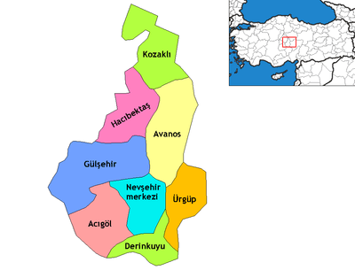 Districts of Nevşehir | ||||||||||||||||||||||||||
| |||||||||||||||||||||||||||
Metropolitan municipalities are bolded. | |||||||||||||||||||||||||||