Chilas
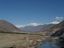
Chilas (Urdu: چلاس) is a historical city of Diamer District located in Gilgit-Baltistan, Pakistan, on the Indus River. It is part of the Silk Road connected by the Karakoram Highway and N-90 National Highway, which link it to Islamabad and Peshawar in the southwest, via Hazara and Malakand Divisions of Khyber Pakhtunkhwa. In the north, Chilas is connected to the Chinese cities of Tashkurgan and Kashgar in Xinjiang, via Gilgit, Aliabad, Sust, and the Khunjerab Pass.
Chilas چلاس | |
|---|---|
 | |
 Chilas  Chilas | |
| Coordinates: 35°25′10″N 74°05′40″E | |
| Country | |
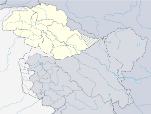
| Autonomous state | Gilgit-Baltistan |
| District | Diamer District |
| Elevation | 1,265 m (4,150 ft) |
| Population (2017-2017) | |
| • Total | 214,000 |
| Languages | |
| • Official | Urdu, Shina[1] |
| Time zone | UTC+5 (PST) |
| PIN | 14100 – 1xx[2] |
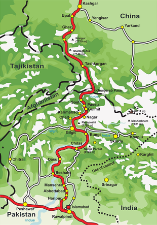
Chilas comes under Gilgit-Baltistan. It is the Headquarters of District Diamir.1(Pamir Times August 2 2012.) The weather is hot and dry in the summer and dry and cold in the winter. It can be reached through the Karakoram highway and also from the Kaghan valley passing over the Babusar Pass. Chilas is situated on the left bank of the mighty Indus River. The beautiful fairy meadows and Nanga Parbat, the seventh highest peak in the world, is also located in Chilas
Recently, Karakoram International University has opened its sub-campus in Chilas to educate the students
History
Even after Kashmiri-British rule was imposed a century ago, the Indus Valley west of Chilas was a hornet’s nest of tiny republics; there was one in almost every side valley, each loosely guided by a jirga (council of tribal elders) but effectively leaderless, all at war with one another and feuding internally. Though administratively lumped with Gilgit, Chilas and its neighbours are temperamentally more like Indus Kohistan, probably owing to a similarly hostile environment and the same Sunni Muslim orthodoxy. Their ancestors were reverted to Islam by a Sufi Muslim [3], he was from the Kaghan valley, Syed Noor Shah, known as Ghazi Baba, was the first man who started preaching Islam in Thak and built the first mosque which is still there (though some changes have been made). Ghazi Baba belonged to the Syed family of Kaghan. In Tangir and Darel, Islam came from the Swat direction. ([4], whereas hardly anyone north of Chilas in the Gilgit-Baltistan province is Sunni.
The large Chilas Fort was first garrisoned to protect British supply lines over the Babusar Pass, and beefed up after local tribes nearly overran it in 1893. Now a police post, it has put a lid on Chilas, though not on the Darel and Tangir Valleys to the west.
Chilasis are Shina speakers, with some Pashtun settlers speaking Pashto. Urdu and some English are also spoken.
Climate
Chilas has a cold semi-arid climate (Köppen: BSk). The average temperature is 28.2 °C (82.8 °F) in July and 5.6 °C (42.1 °F) in January.[5]
Climate data for Chilas, elevation: 1,176 m (3,858 ft), 1982–2012 normals | |||||||||||||
|---|---|---|---|---|---|---|---|---|---|---|---|---|---|
| Month | Jan | Feb | Mar | Apr | May | Jun | Jul | Aug | Sep | Oct | Nov | Dec | Year |
| Average high °C (°F) | 10.2 (50.4) |
13.2 (55.8) |
18.5 (65.3) |
23.9 (75.0) |
29.0 (84.2) |
34.0 (93.2) |
34.7 (94.5) |
33.5 (92.3) |
30.6 (87.1) |
25.3 (77.5) |
19.3 (66.7) |
12.5 (54.5) |
23.7 (74.7) |
| Daily mean °C (°F) | 5.6 (42.1) |
8.2 (46.8) |
13.0 (55.4) |
18.0 (64.4) |
22.3 (72.1) |
26.9 (80.4) |
28.2 (82.8) |
27.4 (81.3) |
23.9 (75.0) |
18.3 (64.9) |
12.5 (54.5) |
7.3 (45.1) |
17.6 (63.7) |
| Average low °C (°F) | 1.1 (34.0) |
3.2 (37.8) |
7.5 (45.5) |
12.1 (53.8) |
15.7 (60.3) |
19.8 (67.6) |
21.8 (71.2) |
21.4 (70.5) |
17.2 (63.0) |
11.3 (52.3) |
5.7 (42.3) |
2.2 (36.0) |
11.6 (52.9) |
| Average precipitation mm (inches) | 17 (0.7) |
25 (1.0) |
42 (1.7) |
46 (1.8) |
35 (1.4) |
10 (0.4) |
17 (0.7) |
19 (0.7) |
8 (0.3) |
18 (0.7) |
6 (0.2) |
11 (0.4) |
254 (10) |
| Source: Climate-Data.org[5] | |||||||||||||
Ancient petroglyphs
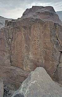

There are more than 50,000 pieces of Buddhist rock art (petroglyphs) and inscriptions all along the Karakoram Highway in Gilgit-Baltistan of Pakistan that are concentrated at ten major sites between Hunza and Shatial, more have been found in the area of Skardu and Shigar (in Shigar even the remains of a Buddhist monastery were found in 1984 by Jettmar and Thewalt). The carvings were left by various invaders, traders and pilgrims who passed along the trade route, as well as by locals. The earliest date back to between 5000 and 1000 BC, showing single animals, triangular men and hunting scenes in which the animals sometimes are larger than the hunters. These carvings were pecked into the rocks with stone tools and are covered with a thick patina that proves their age. Later — mostly Buddhist — carvings were sometimes executed with a sharp chisel.[7]
The ethnologist Karl Jettmar has tried to piece together the history of the area from various inscriptions and recorded his findings in "Rockcarvings and Inscriptions in the Northern Areas of Pakistan" and the later released "Between Gandhara and the Silk Roads: Rock carvings along the Karakoram Highway".
The Kharoshthi term "Kaboa" (or Kamboa) appears in a short commemorative Kharosthi inscription found from Chilas as reported by the Archaeological Department of Pakistan. The inscription has been transcribed, translated and interpreted by Ahmad Hasan Dani, a Pakistani archaeologist, historian, and linguist, who was among the foremost authorities on South Asian archaeology and history. According to Dani, Kaboa or Kamboa of the inscription is a Kharoshthised form of Sanskrit Kamboja.[8][9] Thus, it seems likely that Chilas also formed part of an ancient Kamboja kingdom.
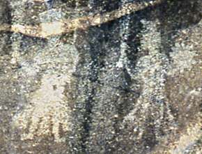 (Bala)rama and Krishna at Chilas. The Kharoshthi inscription nearby reads Rama [kri]ṣa. 1st century CE.[10]
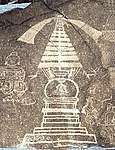
Notes

- "INDO-IRANIAN FRONTIER LANGUAGES". Encyclopaedia Iranica. 15 November 2006. Retrieved 2015-11-06.
- "Post Codes". Pakistan Post Office. Retrieved 22 September 2017.
- Syed Noor Shah Baba
- Asad Ali Khan 1992: 291, English translation by the author)
- "Chilas چلاس climate: Average Temperature, weather by month, Chilas چلاس weather averages - Climate-Data.org". en.climate-data.org. Retrieved 2020-06-04.
- Dated "between A.D. 300-350 based on Kharosthi, Brahmi, and Sodian inscriptions written before and after the drawing was completed (fig.3) In the center of the triptych, a spectacular stupa with a relatively small dome [anda], a chattravali with seven disks, columns, banners, and multiple bells illustrates a trend towards decorative profusion." "Chital petroglyphs". Bulletin of the Asia Institute. Wayne State University Press: 152. 2002.
- See: Volker Thewalt, Stupas und verwandte Bauwerke in Felsbildern am oberen Indus, Wiesenbach 2008, ISBN 978-3-9802753-4-7
- Chilas: The City of Nanga Parvat (Dyamar), 1983, p 120, Ahmad Hasan Dani - Chilās Region (Pakistan)
- See also: The Name 'Cambyses', Pakistan Archaeology, 1991, p 123, Wojciech Skalmowski, Pakistan Dept. of Archaeology & Museums - Pakistan.
- Srinivasan, Doris (1997). Many Heads, Arms, and Eyes: Origin, Meaning, and Form of Multiplicity in Indian Art. BRILL. p. 215. ISBN 978-90-04-10758-8.
References
- Jettmar, Karl & Thewalt, Volker (1985): Zwischen Gandhāra und den Seidenstraßen: Felsbilder am Karakorum Highway: Entdeckungen deutsch-pakistanischer Expeditionen 1979-1984. 1985. Mainz am Rhein, Philipp von Zabern.
- Jettmar, Karl (1980): Bolor & Dardistan. Karl Jettmar. Islamabad, National Institute of Folk Heritage.
- Leitner, G. W. (1893): Dardistan in 1866, 1886 and 1893: Being An Account of the History, Religions, Customs, Legends, Fables and Songs of Gilgit, Chilas, Kandia (Gabrial) Yasin, Chitral, Hunza, Nagyr and other parts of the Hindukush, as also a supplement to the second edition of The Hunza and Nagyr Handbook. And An Epitome of Part III of the author's "The Languages and Races of Dardistan." First Reprint 1978. Manjusri Publishing House, New Delhi.
- Rod MacNeil: The Fight at Chilas (1893). Soldiers of the Queen (journal of the Victorian Military Society). March 1999.