Arkaim
Arkaim (Russian: Аркаим) is an archaeological site of an ancient fortified settlement, situated in the steppe of the Southern Ural, 8.2 km (5.10 mi) north-to-northwest of the village of Amursky and 2.3 km (1.43 mi) south-to-southeast of the village of Alexandrovsky in the Chelyabinsk Oblast of Russia, just north of the border with Kazakhstan.[1] It was discovered in 1987 by a team of archaeologists led by Gennady Zdanovich, preventing the planned flooding of the area for the creation of a reservoir.[2] Arkaim is attributed to the early Proto-Indo-Iranian of the Sintashta culture, which some scholars believe represents the proto-Indo-Iranians before their split into different groups and migration to Central Asia and from there to Persia and India and other parts of Eurasia.[3]
Аркаим (in Russian) | |
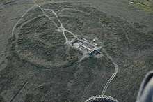 Aerial view of the main citadel | |
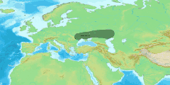
.jpg) Shown within European Russia  Arkaim (Russia) | |
| Location | Bredinsky District, Chelyabinsk Oblast, Russia |
|---|---|
| Region | Kazakh Steppe |
| Coordinates | 52°38′57.34″N 59°34′17.194″E |
| Type | Settlement |
| Area | 2 ha (4.9 acres) |
| History | |
| Periods | Bronze Age |
| Cultures | Sintashta culture |
| Site notes | |
| Archaeologists | Gennady Zdanovich |
| Ownership | Public |
| Public access | Yes |
| Part of a series on |
| Indo-European topics |
|---|
 |
|
|
Philology
|
|
Origins |
|
Archaeology Pontic Steppe
Caucasus East Asia Eastern Europe Northern Europe Pontic Steppe Northern/Eastern Steppe Europe
South Asia Steppe Europe Caucasus India |
|
Peoples and societies Indo-Aryans Iranians
East Asia Europe East Asia Europe
Indo-Aryan Iranian
|
|
Religion and mythology
Indo-Aryan Iranian Others Europe
|
|
Discovery and salvage of the site
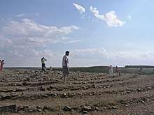
In the summer of 1987 a team of archaeologists headed by Gennady Zdanovich was sent to examine the archaeological value of the valley at the confluence of the Bolshaya Karaganka and Utyaganka rivers, in the south of Chelyabinsk Oblast or the Southern Ural region, where the construction of a reservoir had begun the previous autumn. Some archaeological sites in the area were already known, but they had yielded little and were not considered worthy of preservation. The site would have been flooded by the spring of 1988.[2]
On June 20, two students who took part in the expedition, Aleksandr Voronkov and Aleksandr Ezril, informed the archaeologists about unusual embankments they had found in the steppe. The same evening Zdanovich announced the discovery. The latter would have proven a turning point in the debates about the original homeland of the Indo-Europeans and their migrations, which Soviet specialists had been bitterly disputing about since the 1970s.[2] The near Sintashta culture, excavated in that decade, yielded the remains of an early chariot with horses, making apparent that the southern Urals had been a key location in the development of technology and complex civilisation. The discovery of Arkaim confirmed that assumption.[4]
The struggle to rescue the site was difficult since the reservoir project was overseen by the then all-powerful Ministry of Water Resources of the Soviet Union. The project was scheduled for completion in 1989, but the builders intended to hasten the construction to have it built within the spring of 1988. The archaeologists did their best to mobilise public opinion for the rescue of Arkaim, initially requesting a halt of the project until 1990; academicians and public figures spoke out in their defense. In March 1989 the Praesidium of the Urals Branch of the Academy of Sciences of the Soviet Union formally established a scientific laboratory for the study of the ancient civilisation of Chelyabinsk Oblast. A request was made to the Council of Ministers of the Russian Federation to declare the site as a protected area of historical value.[3]
In the following months the Ministry of Water Resources rapidly lost power as the Soviet Union moved towards collapse. In April 1991 the Council of Ministers officially cancelled the construction of the reservoir and declared Arkaim a "historical and geographical museum".[3]
Structure of Arkaim
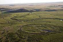
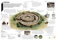
Arkaim was a circular stronghold consisting of two concentric bastions made of adobe with timber frames, and covered with unfired clay bricks. Within the circles, close to the bastions, sixty dwellings stood, The dwellings had hearths, cellars, wells and metallurgical furnaces. They opened towards an inner circular street paved with wood. The street was lined by a covered drainage gutter with pits for water collection. At the centre of the complex was a rectangular open space. The complex had four entrances, consisting of intricately constructed passages and oriented towards the cardinal points. Evidence suggests that the complex was built according to a plan, which indicates that the society had a developed structure of roles and had leaders with great authority.[4]
Scholars have identified the structure of Arkaim as the cities built "reproducing the model of the universe" described in ancient Aryan/Iranian spiritual literature, the Vedas and the Avesta.[3] The structure consists of three concentric rings of walls and three radial streets, reflecting the city of King Yima described in the Rigveda.[5] The foundation walls and the dwellings of the second ring are built according to what some researchers have described as swastika-like patterns;[6] the same symbol is found on various artifacts.[7]
The fortified citadel of Arkaim dates back to the 17th and 16th century BCE. More than twenty other structures built according to similar patterns have been found in a larger area spanning from the southern Urals' region to the north of Kazakhstan, forming the so-called "Land of Towns".[4]
Measures
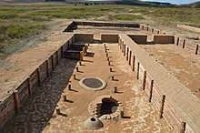
The settlement covered approximately 20,000 square metres (220,000 square feet). The diameter of the enclosing wall was about 160 metres (520 feet), and its thickness was of 4 to 5 metres (13 to 16 feet). The height was 5.5 metres (18.04 feet). The settlement was surrounded with a 2-metre (6-foot-7-inch)-deep moat.
There were four gates, the main was the western one. The dwellings were between 110 to 180 square metres (1,200 to 1,900 square feet) in area. The dwellings of the outer ring were thirty-nine or forty, with doors opening towards the circular street. The dwellings of the inner ring numbered twenty-seven, arranged along the inner wall, with doors opening towards the central square, which was about 25 by 27 metres (82 by 89 feet) in area.
Zdanovich estimates that approximately 1,500 to 2,500 people could have lived in Arkaim. Surrounding Arkaim's walls, were arable fields, 130–140 metres by 45 metres (430–460 feet by 150 feet), irrigated by a system of canals and ditches.
Social impact
Religious movements and mysticism
The discovery of Arkaim reinvigorated the debate about the original homeland of the Indo-Europeans, seemingly confirming its location in central Eurasia.[8] After their discovery, Arkaim and the Land of Towns have been presented as the "land of the Aryans", the centre of a statehood of a monarchical type, and ultimately the model for a new spiritual civilisation harmonised with the universe.[9] Agencies related to the Russian Orthodox Church have been critical of such activities of Arkaim's archaeology.[10]
The discovery of Arkaim and the Land of Towns has fueled the growth of schools of thought among Rodnovers, Rerikhians, Zoroastrians and other movements which regard the archaeological site as the second homeland of the Aryans, who originally dwelt in Arctic regions and migrated southwards when the weather there became glacial, then spreading from central Eurasia to the east, south and west, founding other civilisations. According to them, all Vedic knowledge originated in the southern Urals.[11] Some of them identify Arkaim as the Asgard of Odin spoken of in Germanic literature. The Russian Zoroastrian movement identifies Arkaim as the place where Zoroaster was born.[12] Arkaim is designated as a "national and spiritual shrine" of Russia[3] and has become a holy site for Rodnover, Zoroastrian and other religious movements.[12]
Vladimir Putin's visit and the "Russian idea"
Russia's president Vladimir Putin visited the site in 2005, meeting in person with the chief archaeologist Gennady Zdanovich.[13] The visit received much attention from Russian media. They presented Arkaim as the "homeland of the majority of contemporary people in Asia, and, partly, Europe". Nationalists called Arkaim the "city of Russian glory" and the "most ancient Slavic-Aryan town". Zdanovich reportedly presented Arkaim to the president as a possible "national idea of Russia",[14] a new idea of civilisation which Shnirelman calls the "Russian idea".[15]
See also
References
Citations
- Koryakova, Ludmila; Kohl, Philip L. (2000). "Complex Societies of Central Eurasia from the 3d to the 1st Millennia b.c.: Regional Specifics in the Light of Global Models". Current Anthropology, University of Chicago Press. 41 (4): 638–642. doi:10.1086/317391. JSTOR 10.1086/317391.
- Shnirelman 1998, p. 33.
- Shnirelman 1998, p. 35.
- Shnirelman 1998, p. 34.
- Jones-Bley & Zdanovich 2002, p. 45.
- Jones-Bley & Zdanovich 2002, p. 163.
- Jones-Bley & Zdanovich 2002, p. 324.
- Shnirelman 1998, pp. 33–34.
- Shnirelman 1998, p. 36; Shnirelman 2012, p. 27.
- Petrov, Fedor (29 June 2010). "Наука и неоязычество на Аркаиме (Science and Neopaganism at Arkaim)". Proza.ru. Archived from the original on 7 July 2017. Retrieved 3 July 2017.
- Shnirelman 1998, p. 37.
- Shnirelman 1998, p. 38.
- Shnirelman 2012, pp. 27–28.
- Shnirelman 2012, p. 28.
- Shnirelman 1998, p. 36.
Sources
- Shnirelman, Victor A. (1998). "Archaeology and ethnic politics: the discovery of Arkaim". Museum International. UNESCO, Blackwell Publishers. 50 (2): 33–39. ISSN 1350-0775.CS1 maint: ref=harv (link)
- ——— (2012). "Archaeology and the National Idea in Eurasia". In Charles W. Hartley; G. Bike Yazicioğlu; Adam T. Smith (eds.). The Archaeology of Power and Politics in Eurasia: Regimes and Revolutions. Cambridge University Press. pp. 15–36. ISBN 9781107016521.CS1 maint: extra punctuation (link) CS1 maint: ref=harv (link)
- Jones-Bley, Karlene; Zdanovich, Gennady D. (2002). Complex Societies of Central Eurasia from the 3rd to the 1st Millennium BC. London and New York: Institute for the Study of Man. ISBN 9780941694834.CS1 maint: ref=harv (link)