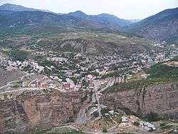
Ardanuç
Ardanuç (Georgian: არტანუჯი, Artanuji; Armenian: Արտանուջ, Artanuj) is a town and district in Artvin Province in Turkey's Black Sea region of Turkey, 32 km east of Artvin. The name Ardanuç derives from Lazuri language and Armenian (Laz: Artanish-Uji; lit. "edge of Ardahan” in Lazuri and “Ard” meaning field in Armenian").
Ardanuç | |
|---|---|
 | |
 Ardanuç | |
| Coordinates: 41°07′43″N 42°03′33″E | |
| Country | Turkey |
| Province | Artvin |
| Government | |
| • Mayor | Yıldırım Demir (CHP) |
| • Kaymakam | Cüneyt Epçim |
| Area | |
| • District | 989.18 km2 (381.92 sq mi) |
| Elevation | 558 m (1,831 ft) |
| Population (2012)[2] | |
| • Urban | 6,332 |
| • District | 11,406 |
| • District density | 12/km2 (30/sq mi) |
| Post code | 08300 |
| Climate | Cfb |
History
The history of this area goes back to the settlement of the banks of the Çoruh River by the Hurri and Mitanni branches of the Hittites in 2000 BC. The first mention of Ardanuç was in a Urartu monument to the defeat of the local people in battle by King Sarduri II in 753 BC. Then in the 7th century BC the Saka or Scythians are known to have settled and they dominated Ardanuç. Since 2nd century BC to 4th century AD this region was a part of Greater Armenia. The castle of Artanuji was built by Georgian king Vakhtang Gorgasali (5th century AD).[3] The castle was besieged by Arab caliph Marwan II (688-750) Ummayad in 744 AD. and was restored by Ashot I (Bagrationi dynasty) in the 8th century.[4] He also founded a city, which became the center of the "Kingdom of Georgians" (ქართველთა სამეფო in Georgian) of Tao-Klarjeti.[5][6]
Fighting between the Bagrationi and Anatolian beyliks began in 1080. Ardanuç being a mountain stronghold was hard to capture, although it did fall to the Mongols during their wars with the Turks and Georgians in the 13th century and was brought into the Ottoman Empire in 1551 by Suleiman the Magnificent following yet another siege, this time to overturn the local ruler, Atabeg of Samtskhe Jakeli.
Following the Russo-Turkish War (1877-1878) Ardanuç was ceded to Russia and after the Russian Revolution it became part of Democratic Republic of Georgia. Georgia was immediately recognized by Germany and the Ottoman Empire. The young state had to place itself under German protection and to cede its largely Muslim-inhabited regions (including the cities of Batum, Ardahan, Artvin, Akhaltsikhe and Akhalkalaki) to the Ottoman government (Treaty of Batum, June 4). with the course of World War I, in 1920 Georgia regained control over Artvin, Ardahan, Akhaltsikhe and Akhalkalaki. after Red army invasion of Georgia, region was occupied by newly formed republic of Turkey.
Iskender Pasha Mosque
The Iskender Pasha Mosque and Tombs (İskender Paşa Camii ve Türbeleri) was commissioned by Iskender Pasha and opened in 1553. It is built in a classical Ottoman style and has four domes. It also contains the tombs of Hatice Hanım, Ali Pasha and Süleyman Pasha.
Geography
Ardanuç is a mountainous district, rising from 250 m (820 ft) in the Şavşat River basin (Şavşat district) up to the highest point, 3,050 m (10,010 ft) Mount Çadır. Other high mountains are Kürdevan, Yalnızçam and Mount Horasan. The town of Ardanuç is on the western side of Yalnızçam Mount and at the conjunction of Bulanık, Aydın and Horhot streams.
The Cehennem Deresi Canyon, located 7 km (4.3 mi) north of Ardanuç, is a tourist attraction.[7]
Climate
Ardanuç has an oceanic climate (Köppen: Cfb).
| Climate data for Ardanuç | |||||||||||||
|---|---|---|---|---|---|---|---|---|---|---|---|---|---|
| Month | Jan | Feb | Mar | Apr | May | Jun | Jul | Aug | Sep | Oct | Nov | Dec | Year |
| Daily mean °C (°F) | −0.2 (31.6) |
1.5 (34.7) |
5.5 (41.9) |
10.9 (51.6) |
14.9 (58.8) |
18.1 (64.6) |
20.9 (69.6) |
21.0 (69.8) |
17.7 (63.9) |
12.9 (55.2) |
7.4 (45.3) |
2.4 (36.3) |
11.1 (52.0) |
| Average precipitation mm (inches) | 80 (3.1) |
70 (2.8) |
56 (2.2) |
63 (2.5) |
63 (2.5) |
67 (2.6) |
49 (1.9) |
54 (2.1) |
67 (2.6) |
88 (3.5) |
91 (3.6) |
101 (4.0) |
849 (33.4) |
| Source: Climate-Data.org[8] | |||||||||||||
Villages
- Akarsu
- Anaçlı
- Aşağıırmaklar
- Aşıklar
- Avcılar
- Aydınköy
- Bağlıca
- Ballı
- Beratlı
- Bereket
- Boyalı
- Bulanık
- Çakıllar
- Cevizlik
- Çıralar
- Ekşinar
- Ferhatlı
- Geçitli
- Gökçe
- Güleş
- Gümüşhane
- Hamurlu
- Harmanlı
- Hisarlı
- İncilli
- Kapıköy
- Karlı
- Kaşıkçı Ardanuç
- Kızılcık
- Konaklı
- Kutlu
- Meşeköy
- Müezzinler
- Naldöken
- Örtülü
- Ovacık
- Peynirli
- Sakarya
- Soğanlı
- Tepedüzü
- Torbalı
- Tosunlu
- Tütünlü
- Ustalar
- Yaylacık
- Yolağzı
- Yolüstü
- Yukarıırmaklar
- Zekeriyaköy
References
- "Area of regions (including lakes), km²". Regional Statistics Database. Turkish Statistical Institute. 2002. Retrieved 2013-03-05.
- "Population of province/district centers and towns/villages by districts - 2012". Address Based Population Registration System (ABPRS) Database. Turkish Statistical Institute. Retrieved 2013-02-27.
- Джуаншер Джуаншериани, Жизнь Вахтанга Горгасала, перевод, введение и примечания Г.В. Цулая, Тб., 1986, p. 79 (in Russian).
- Robert W. Edwards, “The Fortifications of Artvin: A Second Preliminary Report on the Marchlands of Northeast Turkey,” Dumbarton Oaks Papers 39, 1985, pp.171-174, pls.20-30.
- Сумбат Давитис-дзе, История и повествование о Багратионах, пер. М. Д. Лордкипанидзе, р. 31 (in russian)
- Д. Л. Мусхелишвили, Основные вопросы исторической географии Грузии, II, p. 174-176 (in russian)
- "Artvin'deki Cehennem Deresi Kanyonu'nda 'büyüleyen' yolculuk". NTV (in Turkish). 3 May 2018. Retrieved 29 January 2019.
- "Climate:Ardanuç". Climate-Data.org. Retrieved 11 April 2014.
External links
- Governor's Office
- the Municipality
- Photographic survey and plan of Ardanuç Castle
- [ local information] (in Turkish)
Ardanuç in Artvin Province of Turkey | |||||||||||||||||||||||||||
|---|---|---|---|---|---|---|---|---|---|---|---|---|---|---|---|---|---|---|---|---|---|---|---|---|---|---|---|
| Districts |  Districts of Artvin | ||||||||||||||||||||||||||
| |||||||||||||||||||||||||||
Metropolitan municipalities are bolded. | |||||||||||||||||||||||||||
| Authority control |
|
|---|