Alvarado, Texas
Alvarado (/ˌælvəˈreɪdoʊ/ AL-və-RAY-doh) is the oldest city in Johnson County, Texas. The population was 3,785 as of the 2010 census,[6] up from 3,288 at the 2000 census.
Alvarado | |
|---|---|
.jpg) Downtown Alvarado, December 2019 | |
| Motto(s): "The Crossroads of Johnson County"[1] | |
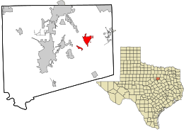 Location in Johnson County and the state of Texas | |
 Alvarado Location in Johnson County and the state of Texas  Alvarado Alvarado (the United States)  Alvarado Alvarado (North America) | |
| Coordinates: 32°24′23″N 97°12′46″W | |
| Country | United States |
| State | Texas |
| County | Johnson |
| Incorporated (city) | 1885 |
| Government | |
| • Type | Manager-council government |
| • Mayor | Tom Durington |
| • City Manager | Rick Holden |
| Area | |
| • Total | 4.89 sq mi (12.68 km2) |
| • Land | 4.15 sq mi (10.76 km2) |
| • Water | 0.74 sq mi (1.92 km2) |
| Elevation | 764 ft (233 m) |
| Population (2010) | |
| • Total | 3,785 |
| • Estimate (2019)[3] | 4,530 |
| • Density | 1,090.78/sq mi (421.14/km2) |
| Time zone | UTC-6 (Central (CST)) |
| • Summer (DST) | UTC-5 (CDT) |
| ZIP code | 76009 |
| Area code(s) | 817 |
| FIPS code | 48-02260[4] |
| GNIS feature ID | 1329475[5] |
| Website | www |
Demographics
| Historical population | |||
|---|---|---|---|
| Census | Pop. | %± | |
| 1880 | 377 | — | |
| 1890 | 1,543 | 309.3% | |
| 1900 | 1,342 | −13.0% | |
| 1910 | 1,155 | −13.9% | |
| 1920 | 1,284 | 11.2% | |
| 1930 | 1,210 | −5.8% | |
| 1940 | 1,324 | 9.4% | |
| 1950 | 1,656 | 25.1% | |
| 1960 | 1,907 | 15.2% | |
| 1970 | 2,129 | 11.6% | |
| 1980 | 2,701 | 26.9% | |
| 1990 | 2,918 | 8.0% | |
| 2000 | 3,288 | 12.7% | |
| 2010 | 3,785 | 15.1% | |
| Est. 2019 | 4,530 | [3] | 19.7% |
| U.S. Decennial Census[7] | |||
As of the census[4] of 2000, there were 3,288 people, 1,151 households, and 834 families residing in the city. The population density was 842.5 people per square mile (325.5/km²). There were 1,266 housing units at an average density of 324.4 per square mile (125.3/km²). The racial makeup of the city was 81.30% White, 7.15% African American, 0.61% Native American, 0.43% Asian, 9.25% from other races, and 1.28% from two or more races. Mexicans or Latino of any race were 18.46% of the population.
There were 1,151 households out of which 37.6% had children under the age of 18 living with them, 51.8% were married couples living together, 13.6% had a female householder with no husband present, and 27.5% were non-families. 23.5% of all households were made up of individuals and 11.3% had someone living alone who was 65 years of age or older. The average household size was 2.77 and the average family size was 3.26.
In the city, the population was spread out with 29.6% under the age of 18, 9.0% from 18 to 24, 28.5% from 25 to 44, 20.2% from 45 to 64, and 12.7% who were 65 years of age or older. The median age was 32 years. For every 100 females, there were 99.8 males. For every 100 females age 18 and over, there were 93.2 males.
The median income for a household in the city was $31,166, and the median income for a family was $36,471. Males had a median income of $30,690 versus $22,181 for females. The per capita income for the city was $14,476. About 11.7% of families and 14.1% of the population were below the poverty line, including 15.5% of those under age 18 and 17.4% of those age 65 or over.
Geography
Alvarado is located in eastern Johnson County at 32°24′23″N 97°12′46″W (32.406342, -97.212792),[8] at the intersection of US Highway 67 and Interstate 35W. The city is 26 miles (42 km) south of the center of Fort Worth and 39 miles (63 km) southwest of Dallas.
According to the U.S. Census Bureau, Alvarado has a total area of 4.8 square miles (12.5 km2), of which 4.1 square miles (10.6 km2) are land and 0.73 square miles (1.9 km2), or 15.35%, are water.[6] The water area comprises Alvarado Park Lake, a reservoir on Turkey Creek 3 miles (5 km) southwest of the city. Alvarado is drained by the North Fork of Chambers Creek, a southeast-flowing stream that is part of the Trinity River watershed.
Alvarado's nearest neighboring communities are Venus to the east, Keene to the west, Burleson to the north, and Grandview to the south.
Climate
The climate in this area is characterized by hot, humid summers and generally mild to cool winters. According to the Köppen Climate Classification system, Alvarado has a humid subtropical climate, abbreviated "Cfa" on climate maps.[9]
Economy
Alvarado is a rural community with an economy that has been primarily agricultural with only a modest retail and industrial base. In recent years the trend has been away from agriculture and toward more urban development. In 2007 Sabre Tubular Structures built a new 200,000-square-foot (19,000 m2) facility located on 147 acres (59 ha) on the eastern side of town. Sabre has over 200 employees at this facility.[10] The city received a 2008 grant of $750,000 from the Texas Department of Agriculture for infrastructure improvements related to Sabre.[11]
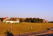
In 2008 and 2009 there was an upturn in retail development with the opening of three national chain hotels and two fast food dining establishments. A movie theater/tavern was opened for a short time before closing its door due to poor sales and a general lack of interest.
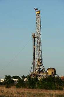
Barnett Shale
In the latter part of the 2000s, development of natural gas wells in the Barnett Shale has been a source of prosperity for the city and many property owners have benefited from drilling activity, pipeline construction and royalty payments. As natural gas prices fell in 2009, drilling activity and royalty payments declined rapidly.
Recreation
- Alvarado Park Lake is located on the west side of the city, three miles (5 km) west of I-35W.
- Alvarado Parkway Park
Government
The city uses a Council-manager government with a mayor and six city council members representing three wards, one being the mayor pro-tem.
The city's 2009–10 general fund budget is $3.9 million.[12]
Education
The city is served by the Alvarado Independent School District. There are no colleges or universities in Alvarado, although residents pay a Hill College maintenance tax and residents receive in-district student rates.
Notable people
- Terry Southern, author, born in Alvarado
- Johnny Trigg, famous barbecuer - Rib King
- Andrew Sevener, The Voice finalist season 16 (Team Blake)
See also
References
- "City of Alvarado". City of Alvarado. Retrieved December 18, 2018.
- "2019 U.S. Gazetteer Files". United States Census Bureau. Retrieved June 26, 2020.
- "Population and Housing Unit Estimates". United States Census Bureau. May 24, 2020. Retrieved May 27, 2020.
- "U.S. Census website". United States Census Bureau. Retrieved 2008-01-31.
- "US Board on Geographic Names". United States Geological Survey. 2007-10-25. Retrieved 2008-01-31.
- "Geographic Identifiers: 2010 Census Summary File 1 (G001): Alvarado city, Texas". American Factfinder. U.S. Census Bureau. Archived from the original on February 13, 2020. Retrieved December 18, 2018.
- "Census of Population and Housing". Census.gov. Retrieved June 4, 2015.
- "US Gazetteer files: 2010, 2000, and 1990". United States Census Bureau. 2011-02-12. Retrieved 2011-04-23.
- Climate Summary for Alvarado, Texas
- "Sabre Tubular Structures Announces New Manufacturing Facility in Alvarado, Texas". Sabre Tubular Structures. Retrieved 2010-01-16.
- "Commissioner Todd Staples Awards City Of Alvarado $750,000 For Economic Development". Texas Department of Agriculture. Archived from the original on 26 January 2010. Retrieved 2010-01-16.
- "City of Alvarado Proposed Annual Budget Fiscal Year 2009-2010". City of Alvarado. Retrieved 2010-01-16.
External links
| Wikimedia Commons has media related to Alvarado, Texas. |
- Official website
- Alvarado, Texas from the Handbook of Texas Online
Municipalities and communities of Johnson County, Texas, United States | ||
|---|---|---|
| Cities |  Johnson County map | |
| Towns | ||
| Unincorporated communities | ||
| Footnotes | ‡This populated place also has portions in an adjacent county or counties | |
| Authority control |
|
|---|