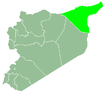
Al-Hasakah Governorate
Al-Hasakah Governorate (Arabic: محافظة الحسكة, romanized: Muḥāfaẓat al-Ḥasakah, Kurdish: Parêzgeha Hesîçe, Classical Syriac: ܗܘܦܪܟܝܐ ܕܚܣܟܗ, romanized: Huparkiyo d'Ḥasake, also known as Classical Syriac: ܓܙܪܬܐ, romanized: Gozarto) is one of the fourteen governorates (provinces) of Syria. It is located in the far north-east corner of Syria and distinguished by its fertile lands, plentiful water, natural environment, and more than one hundred archaeological sites. It was formerly known as Al-Jazira Province. Prior to the Syrian Civil War nearly half of Syria's oil was extracted from the region.[2] The area is coextensive with that governed by the Autonomous Administration of North and East Syria.
Hasakah Governorate محافظة الحسكة | |
|---|---|
.svg.png) Map of Syria with Al Hasakah highlighted | |
| Coordinates (Hasakah): 36.5°N 40.9°E | |
| Country | |
| Capital | Al-Hasakah |
| Districts | 4 |
| Government | |
| • Governor | Major General Jaiz Swadet al-Hamoud al-Musa |
| Area | |
| • Total | 23,334 km2 (9,009 sq mi) |
| Population (31/12/2011) | |
| • Total | 1,512,000[1] |
| Time zone | UTC+2 (EET) |
| • Summer (DST) | UTC+3 (EEST) |
| ISO 3166 code | SY-HA |
| Main language(s) | Arabic, Kurdish, Syriac, Assyrian Neo-Aramaic, Armenian |
| Ethnicities | Kurds, Arabs, Assyrians, Armenians & Yazidis |
History
Three soldiers were killed by armed militants in Al-Hasakah in an ambush during the Syrian Civil War on 24 March 2012.[3] About a year later, local forces launched the 2013 Al-Hasakah offensive.
After the battle of al-Hasakah in August 2016 between Kurds and the Bashar al-Assad regime, the area was mostly in People's Protection Units (YPG) control.[4]
Demographics and population
Until the beginning of the 20th century, al-Hasakah Governorate (then called Jazira province) was a “no man’s land” primarily reserved for the grazing land of nomadic and semi-nomadic tribes.[5] During WWI and subsequent years, thousands of Assyrians fled their homes in Anatolia after massacres. After that, massive waves of Kurds fled their homes in Turkey due to conflict with Kemalist authorities and settled in Syria, where they were granted citizenship by the French Mandate authorities.[6] The number of Kurds settled in the Jazira province during the 1920's was estimated at 20,000 people.[7]
French authorities were not opposed to the streams of Assyrians, Armenians or Kurds who, for various reasons, had left their homes and had found refuge in Syria. The French authorities themselves generally organized the settlement of the refugees. One of the most important of these plans was carried out in Upper Jazira in northeastern Syria where the French built new towns and villages (such as Qamishli) were built with the intention of housing the refugees considered to be “friendly”. This has encouraged the non-Turkish minorities that were under Turkish pressure to leave their ancestral homes and property, they could find refuge and rebuild their lives in relative safety in neighboring Syria.[8] Consequently, the border areas in al-Hasakah Governorate started to have a Kurdish majority, while Arabs remained the majority in river plains and elsewhere.
In 1939, French mandate authorities reported the following population numbers for the different ethnic and religious groups in al-Hasakah city centre.[9]
| District | Arab | Kurd | Christian | Armenian | Yezidi | Assyrian |
|---|---|---|---|---|---|---|
| Hasakah city centre | 7133 | 360 | 5700 | 500 | ||
| Tel Tamer | 8767 | |||||
| Ras al-Ayn | 2283 | 1025 | 2263 | |||
| Shaddadi | 2610 | 6 | ||||
| Tel Brak | 4509 | 905 | 200 | |||
| Qamishli city centre | 7990 | 5892 | 14,140 | 3500 | 720 | |
| Amuda | 11,260 | 1500 | 720 | |||
| Derbasiyeh | 3011 | 7899 | 2382 | 425 | ||
| Shager Bazar | 380 | 3810 | 3 | |||
| Ain Diwar | 3608 | 900 | ||||
| Derik (later renamed al-Malikiyah) | 44 | 1685 | 1204 | |||
| Mustafiyya | 344 | 959 | 50 | |||
| Derouna Agha | 570 | 5097 | 27 | |||
| Tel Koger (later renamed Al-Yaarubiyah) | 165 |
The population of the governorate reached 155,643 in 1949, including about 60,000 Kurds.[10]
The inhabitants of al-Hasakah governorate are composed of different ethnic and cultural groups, the larger groups being Arabs and Kurds in addition to a significant large number of Assyrians and a smaller number of Armenians.[11] The population of the governorate, according to the country's official census, was 1,275,118, and was estimated to be 1,377,000 in 2007, and 1,512,000 in 2011.
| Historical population | ||
|---|---|---|
| Year | Pop. | ±% |
| 1931 | 44,153 | — |
| 1933 | 64,886 | +47.0% |
| 1935 | 94,596 | +45.8% |
| 1937 | 98,144 | +3.8% |
| 1938 | 103,514 | +5.5% |
| 1939 | 106,052 | +2.5% |
| 1940 | 126,508 | +19.3% |
| 1942 | 136,107 | +7.6% |
| 1943 | 146,001 | +7.3% |
| 1946 | 151,137 | +3.5% |
| 1950 | 159,300 | +5.4% |
| 1953 | 232,104 | +45.7% |
| 1960 | 351,661 | +51.5% |
| 1970 | 468,506 | +33.2% |
| 1981 | 669,756 | +43.0% |
| 2004 | 1,275,118 | +90.4% |
| 2011 | 1,512,000 | +18.6% |
Censuses of 1943 and 1953
| Religious group | Population (1943) |
Percentage (1943) |
Population (1953) |
Percentage (1953) | |
|---|---|---|---|---|---|
| Muslims | Sunni Muslims | 99,665 | 68.26% | 171,058 | 73.70% |
| Other Muslims | 437 | 0.30% | 503 | 0.22% | |
| Christians | Syriac Orthodox & Syriac Catholic | 31,764 | 21.76% | 42,626 | 18.37% |
| Armenians | 9,788 | 6.70% | 12,535 | 5.40% | |
| Other churches | 944 | 0.65% | 1,283 | 0.55% | |
| Total Christians | 42,496 | 29.11% | 56,444 | 24.32% | |
| Jews | 1,938 | 1.33% | 2,350 | 1.01% | |
| Yazidis | 1,475 | 1.01% | 1,749 | 0.75% | |
| TOTAL | Al-Jazira province | 146,001 | 100.0% | 232,104 | 100.0% |
Among the Sunni Muslims, mostly Kurds and Arabs, there were about 1,500 Circassians in 1938.[14]
In 1949, there were officially 155,643 inhabitants. The French geographers Fevret and Gibert estimated that there were about 50,000 Arabs, 60,000 Kurds, a few thousands Jews and Yezidis, the rest being Christians of various denominations.[15]
Cities, towns and villages
This list includes all cities, towns and villages with more than 5,000 inhabitants. The population figures are given according to the 2004 official census:[16]
| English Name | Population | District |
|---|---|---|
| Al-Hasakah | 188,160 | Al-Hasakah District |
| Qamishli | 184,231 | Qamishli District |
| Ras al-Ayn | 29,347 | Ras al-Ayn District |
| Amuda | 26,821 | Qamishli District |
| Al-Malikiyah | 26,311 | Al-Malikiyah District |
| Al-Qahtaniyah | 16,946 | Qamishli District |
| Al-Shaddadi | 15,806 | Al-Hasakah District |
| Al-Muabbada | 15,759 | Al-Malikiyah District |
| Al-Sabaa wa Arbain | 14,177 | Al-Hasakah District |
| Al-Manajir | 12,156 | Ras al-Ayn District |
| Al-Darbasiyah | 8,551 | Ras al-Ayn District |
| Tell Tamer | 7,285 | Al-Hasakah District |
| Al-Jawadiyah | 6,630 | Al-Malikiyah District |
| Mabrouka | 6,325 | Ras al-Ayn District |
| Al-Yaarubiyah | 6,066 | Al-Malikiyah District |
| Tell Safouk | 5,781 | Al-Hasakah District |
| Tell Hamis | 5,161 | Qamishli District |
| Al-Tweinah | 5,062 | Al-Hasakah District |
| Al-Fadghami | 5,062 | Al-Hasakah District |
According to the National Association of Arab Youth, there are 1717 villages in Al-Hasakah province: 1161 Arab villages, 453 Kurdish villages, 98 Assyrian villages and 53 with mixed populations from the aforementioned ethnicities.[17]
| Arab villages | 1161 |
| Kurdish villages | 453 |
| Assyrian villages | 98 |
| Mixed Arab-Kurdish villages | 48 |
| Mixed villages | 3 |
| Mixed villages | 2 |
| Total | 1717 |
Districts and sub-districts
The governorate has 4 districts (Mintaqa's). These are further divided into 16 sub-districts (nawahi):
Archaeology
The Khabur River, which flows through al-Hasakah for 440 kilometres (270 mi), witnessed the birth of some of the earliest civilizations in the world, including those of Akkad, Assyria, the Hurrians and Amorites. The most prominent archaeological sites are:
- Hamoukar:considered by some archaeologists to be the oldest city in the world
- Tell Halaf: Excavations have revealed successive civilization levels, Neolithic glazed pottery and basalt sculptures.
- Tell Brak: Situated halfway between al-Hasakah city and the frontier town of Qamishli. Excavations in the tell have revealed the Uyun Temple and King Naram-Sin's palace-stronghold.
- Tell el Fakhariya
- Tell Hittin: 15 layers of occupation have been identified.
- Tell Leilan: Excavations began in 1975 and have revealed many artefacts and buildings dating back to the 6th millennium BC such as a bazaar, temple, palace, etc.
References
- http://cbssyr.org/yearbook/2011/Data-Chapter2/TAB-3-2-2011.htm%5B%5D
- Al Monitor, Syria's Oil Crisis, 2013, http://www.al-monitor.com/pulse/ru/originals/2013/02/syria-oil-crisis.html# Archived 2014-07-14 at the Wayback Machine
- Fresh clashes break out in Damascus
- Barnard, Anne (August 23, 2016). "Kurds Close to Control of Northeast Syria Province, Portending a Shift in the War". NYT. Retrieved August 24, 2016.
- Algun, S., 2011. Sectarianism in the Syrian Jazira: Community, land and violence in the memories of World War I and the French mandate (1915- 1939). Ph.D. Dissertation. Universiteit Utrecht, the Netherlands. Pages 18. Accessed on 8 December 2019.
- Dawn Chatty (2010). Displacement and Dispossession in the Modern Middle East. Cambridge University Press. pp. 230–232. ISBN 978-1-139-48693-4.
- Simpson, John Hope (1939). The Refugee Problem: Report of a Survey (First ed.). London: Oxford University Press. p. 458. ASIN B0006AOLOA.
- Tachjian Vahé, The expulsion of non-Turkish ethnic and religious groups from Turkey to Syria during the 1920s and early 1930s , Online Encyclopedia of Mass Violence, [online], published on: 5 March, 2009, accessed 09/12/2019, ISSN 1961-9898
- Algun, S., 2011. Sectarianism in the Syrian Jazira: Community, land and violence in the memories of World War I and the French mandate (1915- 1939). Ph.D. Dissertation. Universiteit Utrecht, the Netherlands. Pages 11-12. Accessed on 8 December 2019.
- La Djezireh syrienne et son réveil économique André Gibert, Maurice Févret, 1953. La Djezireh syrienne et son réveil économique. In: Revue de géographie de Lyon, vol. 28, n°1, 1953. pp. 1-15; doi : https://doi.org/10.3406/geoca.1953.1294 Accessed on 8 December 2019.
- Syria - Sunnis
- Hourani, Albert Habib (1947). Minorities in the Arab World. London: Oxford University Press. pp. 76.
- Etienne, de Vaumas (1956). "La Djézireh". Annales de Géographie (in French). 65 (347): 64–80. Retrieved 2012-03-29.
- M. Proux, "Les Tcherkesses", La France méditerranéenne et africaine, IV, 1938
- Fevret, Maurice; Gibert, André (1953). "La Djezireh syrienne et son réveil économique". Revue de géographie de Lyon (in French) (28): 1–15. Retrieved 2012-03-29.
- "Archived copy" (PDF). Archived from the original (PDF) on 2013-03-10. Retrieved 2013-11-04.CS1 maint: archived copy as title (link)
- National Association of Arab Youth, 2012. Arab East Centre, London, 2012. Study of the demographic composition of al-Hasakah Governorate (in Arabic). Accessed on 26 December 2014.
External links
- ehasakeh The First Complete website for Al-Hasakah news and services
Places adjacent to Al-Hasakah Governorate | ||||||||||
|---|---|---|---|---|---|---|---|---|---|---|
| ||||||||||
Ethno-linguistic group(s) indigenous to the Middle East with various additional self-identification, such as Syriacs, Arameans, or Chaldeans | |||||||||
| Identity | |||||||||
| Syriac Christianity |
| ||||||||
| Aramaic/Syriac languages | |||||||||
| Culture | |||||||||
| History (including related contexts) |
| ||||||||
| By country |
| ||||||||
| Politics | |||||||||
| |||||||||