Agadez Region
Agadez Region is one of the eight Regions of Niger. At 667,799 square kilometres (257,839 sq mi), it covers more than half of Niger's land area is the largest Region in the country, as well as the largest African state subdivision. The capital of the department is Agadez.
Agadez | |
|---|---|
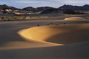 Desert near Arakao | |
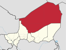 Location within Niger | |
| Coordinates: 17°0′N 8°0′E | |
| Country | |
| Capital | Agadez |
| Government | |
| • Governor | Sadou Soloké |
| Area | |
| • Total | 667,799 km2 (257,839 sq mi) |
| Population (2012 census[1]) | |
| • Total | 487,620 |
| • Density | 0.73/km2 (1.9/sq mi) |
| Time zone | UTC+1 (West Africa Time) |
| HDI (2017) | 0.450[2] low |
History
The region is a centre for palaeontology, with numerous dinosaur skeletons being found here, including the Ouranosaurus nigeriensis.[3] Cave painting and the remains of ancient human settlements are also located here.[3] Tuareg peoples began migrating to the region from the mid-8th century.[3] From the mid-15th century to the early 20th, much of the region was under the control of the Sultanate of Agadez, except for a period when the area came under the rule of the Songhai Empire in the 1500s.[3]
The region suffered with the advent of French colonialism as power shifted away to the southwest; Tuareg disaffection with French rule resulted in the Kaocen revolt in 1916-17.[3] This process continued following Niger's independence in 1960; local Tuareg saw little recompense from the uranium mining boom in Arlit in the 1970s, and Agadez Region was struck by repeated draughts and famines.[3] Since then there have been two Tuareg rebellions: from 1990-95 and 2007-09.[3] In recent years the region has also been affected by the actions of Islamist groups.
Geography
Agadez Region borders Algeria (Tamanrasset Province and Illizi Province) and Libya (Murzuq District) to the north, Chad to the east, Diffa Region, Zinder Region, Tahoua Region and Maradi Region to the south, and Mali (Kidal Region) to the west. It is by far the largest region of the country, representing 52% of the total area of Niger. The region is dominated by the Sahara desert, and includes the vast Ténéré portion of that desert, as well as dune seas such as the Erg of Bilma.[3] The Aïr Mountains, the tallest peaks in Niger, are also located here.[3] The Djado Plateau is located in the far north.
Settlements
Agadez is the regional capital; other major settlements include Aderbissinat, Arlit, Assamakka, Bilma, Dirkou, Iferouane, In-Gall, Madama, Séguedine, Tchirozerine, Tegguiada In Tessoum and Timia.[4]
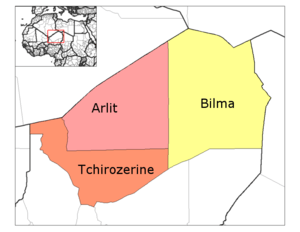
Administrative subdivisions
Agadez is divided into three Departments and one Commune.
| Commune | Size | Population | ||
|---|---|---|---|---|
| Agadez | ....... | 78 289 inhabitants | ||
| Department | Size | Population | Chief Town | Cantons |
| Arlit | 216 774 km2 | 98 170 inhabitants | Arlit | |
| Bilma | 296 279 km2 | 17 080 inhabitants | Bilma | Bilma, Djado, Fachi, Kawar |
| Tchirozérine | 154 746 km2 | 118 068 inhabitants | Tchirozérine |
Demographics
Despite its size, Agadez is sparsely populated. Its 487,620 inhabitants (as per the 2012 census)[5] account for only 2.8% of the total population of Niger, with a population density of 0.73 inhabitants per square kilometre (1.9/sq mi). Much of its population comprises nomadic or semi-nomadic peoples, including Arabs, Fulani, Kanuri, Dazaga Toubou and various Tuareg groups. The Tagdal language and Tasawaq language, thought to be mixed Songhai-Tuareg languages, are also spoken.[6]
| Historical population | ||
|---|---|---|
| Year | Pop. | ±% |
| 1977 | 124,985 | — |
| 1985 | 208,828 | +67.1% |
| 2001 | 321,639 | +54.0% |
| 2012 | 487,620 | +51.6% |
| source:[7] | ||
Economy

Traversed for centuries by the Trans Saharan trade routes, the oasis towns of the Aïr and the eastern Kaouar Cliffs are known for their gardens, salt manufacture, and date cultivation. Arlit is the centre of Niger's uranium industry, a prominent economic sector in the region with uranium pits and mines operated by foreign companies providing substantial revenue for the country. The French discovered Niger's first uranium deposits in the Tim Mersoi Basin of the Agadez Region in 1958 and since then French companies such as Areva have maintained a large footprint in the region, employing a large quantity of locals.[8][9] Depressed uranium prices since the 1980s have hit the region hard, though uranium remains one of the main foreign exchange earners for the country.
Agadez had historically been one of the main centres of tourism in Niger, with visitors attracted by the desert scenery, archaeological sites and the Air Mountains. However Tuareg rebellions and activities of Islamist militants in Agadez region have severely reduced the numbers of tourists, with most third party governments advising against travel to the region.[10]
References
- Niger at Geohive Archived 2015-04-20 at the Wayback Machine
- "Sub-national HDI - Area Database - Global Data Lab". hdi.globaldatalab.org. Retrieved 2018-09-13.
- Geels, Jolijn, (2006) Bradt Travel Guide - Niger, pgs. 157-200
- "Niger: Region D'agadez: Carte référentielle (25 Juin 2014)" (PDF). UNOCHA. Retrieved 2 November 2019.
- Niger at Geohive Archived 2015-04-20 at the Wayback Machine
- "Languages of Niger". Ethnologue. Retrieved 24 October 2019.
- Niger: Administrative Division population statistics
- Michael Klare (13 March 2012). The Race for What's Left: The Global Scramble for the World's Last Resources. Henry Holt and Company. pp. 192–. ISBN 978-1-4299-7330-4.
- International Business Publications, USA (3 March 2008). Niger Mining Laws and Regulations Handbook. Int'l Business Publications. pp. 67–. ISBN 978-1-4330-7798-2.
- Australian DFAT Travel Advice - Niger, 5 October 2019
External links
