Tillabéri Region
Tillabéri (var. Tillabéry) is one of the eight Regions of Niger; the capital of the Region is Tillabéri. Tillabéri Region was created in 1992, when Niamey Region was split, with Niamey and its immediate hinterland becoming a new capital district enclaved within Tillabéri Region.[3]
Tillabéri | |
|---|---|
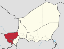 Location within Niger | |
| Coordinates: 14°13′N 1°27′E | |
| Country | |
| Capital | Tillabéri |
| Government | |
| • Governor | Hassoumi Djabirou |
| Area | |
| • Total | 89,623 km2 (34,604 sq mi) |
| Population (2012[1]) | |
| • Total | 2,722,482 |
| • Density | 30/km2 (79/sq mi) |
| Time zone | UTC+1 (West Africa Time) |
| HDI (2017) | 0.448[2] low |
Geography
Tillabéri borders Mali (Gao Region) to the north, Tahoua Region to the east, Dosso Region to the southeast, Benin (Alibori Department) to the south, and Burkina Faso (Sahel Region and Est Region) to the west. The Niamey Capital District forms an enclave within the region. Tillabéri contains almost all of Niger's share of the Niger river, as well as several seasonal (known as Gorouol, Sirba) and permanent (known as Mékrou, Tapoa) watercourses. The W National Park is located in the extreme south of the region and extends into Burkina Faso and Benin. The northwestern areas of the region (Ouallam and Filingué) have a savannah type flora and fauna.
Settlements
Tillabéri is the regional capital; other major settlements include Abala, Ayourou, Banibangou, Bankilare, Filingue, Ouallam, Say, Téra and Torodi.[4]
Administrative subdivisions

Tillabéri is divided into 6 departments:
- Filingue Department
- Kollo Department
- Ouallam Department
- Say Department
- Téra Department
- Tillaberi Department
Climate
| Climate data for Tillaberi (1961-1990) | |||||||||||||
|---|---|---|---|---|---|---|---|---|---|---|---|---|---|
| Month | Jan | Feb | Mar | Apr | May | Jun | Jul | Aug | Sep | Oct | Nov | Dec | Year |
| Average high °C (°F) | 32.3 (90.1) |
35.6 (96.1) |
38.9 (102.0) |
41.4 (106.5) |
41.5 (106.7) |
38.8 (101.8) |
35.4 (95.7) |
33.7 (92.7) |
35.6 (96.1) |
38.4 (101.1) |
36.4 (97.5) |
33.0 (91.4) |
36.7 (98.1) |
| Daily mean °C (°F) | 24.6 (76.3) |
27.5 (81.5) |
30.9 (87.6) |
33.6 (92.5) |
34.7 (94.5) |
32.7 (90.9) |
30.2 (86.4) |
28.9 (84.0) |
30.1 (86.2) |
31.2 (88.2) |
28.4 (83.1) |
25.3 (77.5) |
29.8 (85.7) |
| Average low °C (°F) | 17.0 (62.6) |
19.4 (66.9) |
22.8 (73.0) |
25.9 (78.6) |
27.9 (82.2) |
26.7 (80.1) |
24.9 (76.8) |
24.1 (75.4) |
24.5 (76.1) |
23.9 (75.0) |
20.4 (68.7) |
17.5 (63.5) |
22.9 (73.2) |
| Average precipitation mm (inches) | 0.0 (0.0) |
0.0 (0.0) |
2.3 (0.09) |
5.6 (0.22) |
16.6 (0.65) |
46.8 (1.84) |
102.7 (4.04) |
143.1 (5.63) |
69.9 (2.75) |
10.8 (0.43) |
0.3 (0.01) |
0.1 (0.00) |
398.2 (15.66) |
| Mean monthly sunshine hours | 285.2 | 260.4 | 269.7 | 246.0 | 272.8 | 255.0 | 248.0 | 235.6 | 249.0 | 279.0 | 279.0 | 279.0 | 3,175.5 |
| Source: NOAA [5] | |||||||||||||
Demographics
As of 2012 the population of the region was 2,722,482.[6] The main ethnolinguistic grousp are the Fulani, Gurma, Hausa, Tuareg, Zarma (also referred to as 'Djerma').[7]
| Historical population | ||
|---|---|---|
| Year | Pop. | ±% |
| 1977 | 928,849 | — |
| 1985 | 1,328,283 | +43.0% |
| 2001 | 1,872,436 | +41.0% |
| 2012 | 2,722,482 | +45.4% |
| source:[8] | ||
Economy
The economy of the region of Tillabéri is based primary on agriculture, livestock and fishery production. However, Tillabéri is rich in mineral resources (gold and iron ore) and increasingly becoming attractive for future mining investments. In 2004, the first gold mine in Téra began operation. In addition, the region of Tillabéri has great touristic potential with W Park, the Niger river and many more attractions.
Agriculture, livestock and fishery
Based on data from the National Statistics Institute of Niger, The region of Tillaberi is 1st producer of rice (5,700 tonnes), 5th for sorghum (40,900 tonnes), 5th for millet (39,9400 tonnes), 3rd for corn (1,100 tonnes), 5th for black-eyed peas (15,3000 tonnes) and 5th in peanut (2,400 tonnes) in 2011 among regions.[9] It is also an important livestock producer and the 1st producer of cattle with recorded 2087 thousand cattle heads in 2011.[10] Although the Niger river is crossing through this region, it is only the 3rd producer of fishery products with 637 thousand tonnes in 2011.[11]
Tourism

The region of Tillabéri has many tourist sites. The W National Park of Niger, which straddles the tri-border area of Benin-Burkina Faso-Niger, is classified as a World Heritage Site by UNESCO.[14] The park contains a wide variety of fauna and flora on side located in Niger.. The region has a modest hospitality infrastructure with only two 4-star hotels and 137 rooms (42 rooms for the 4 star hotels).[15]
References
| Wikimedia Commons has media related to Tillabéri Region. |
- Annuaire statistique du Niger
- "Sub-national HDI - Area Database - Global Data Lab". hdi.globaldatalab.org. Retrieved 2018-09-13.
- According to Statsoid Archived 2009-07-24 at the Wayback Machine: "~1992: Tillabéry Region split from Niamey (whose FIPS code was NG05 before the change). Status of Niamey changed from Region to capital district."
- "Niger: Tillaberi: Carte référentielle (20 janvier 2018)" (PDF). UNOCHA. Retrieved 1 November 2019.
- "Tillabery Climate Normals". National Oceanic and Atmospheric Administration. Retrieved April 9, 2016.
- Annuaire statistique du Niger
- "Languages of Niger". Ethnologue. Retrieved 24 October 2019.
- Niger: Administrative Division population statistics
- Annuaire statistique du Niger - Agriculture
- Annuaire statistique du Niger - Eleveage
- Annuaire statistique du Niger - Peche
- Samira Hill Gold Mine: African Development Information Database Archived 2008-11-22 at the Wayback Machine.
- Niger Mining
- United Nations Educational, Scientific and Cultural Organization (n.d.), World Heritage List, archived from the original on 1 November 2015, retrieved 5 November 2015.
- - Tillaberi