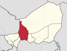
Tahoua Region
Tahoua is one of eight Regions of Niger. The capital of the region is the commune of Tahoua. The region covers 106,677 km².
Tahoua | |
|---|---|
 Location within Niger | |
| Coordinates: 14°53′N 5°16′E | |
| Country | |
| Capital | Tahoua |
| Area | |
| • Total | 106,677 km2 (41,188 sq mi) |
| Population (2011[1]) | |
| • Total | 2,741,922 |
| • Density | 26/km2 (67/sq mi) |
| Time zone | UTC+1 (West Africa Time) |
| HDI (2017) | 0.313[2] low |
Geography
Tahoua borders Agadez Region to the northeast, Maradi Region to the southeast, Nigeria's Sokoto State to the south, and Mali (Gao and Kidal regions), Dosso Region and Tillabéri Region to the west. Much of the region lies with the Sahel, merging into the Sahara desert in the north.
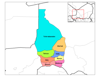
Settlements
Tahoua is the regional capital; other major settlements include Abalak, Bagaroua, Birni-N'Konni, Bouza, Illela, Keita, Madaoua and Tchintabaraden.[3]
Demographics
As of 2011 the population of Tahoua Region was 2,741,922.[4] The main ethnolinguistic groups are the Fulani, Hausa and Tuareg; the Tagdal language, thought to be a mixed Songhay-Tuareg language, is also spoken.[5]
| Historical population | ||
|---|---|---|
| Year | Pop. | ±% |
| 1977 | 993,615 | — |
| 1985 | 1,308,598 | +31.7% |
| 2001 | 1,972,907 | +50.8% |
| 2012 | 3,328,365 | +68.7% |
| source:[6] | ||
References
http://www.stat-niger.org/statistique/file/Affiches_Depliants/Nigerenchiffres2014def.pdf
- Annuaire statistique du Niger
- "Sub-national HDI - Area Database - Global Data Lab". hdi.globaldatalab.org. Retrieved 2018-09-13.
- "Niger: Region de Tahoua - Carte Administrative (au 4 juin 2014)" (PDF). UNOCHA. Retrieved 30 October 2019.
- Annuaire statistique du Niger
- "Languages of Niger". Ethnologue. Retrieved 24 October 2019.
- Niger: Administrative Division population statistics
- Portions of this article were translated from the French language Wikipedia article fr:Tahoua (région).