Dosso Region
Dosso is one of the eight Regions of Niger. The region has an area of 31,002 square kilometres (11,970 sq mi), with a population of 2,078,339 as of 2011.[3]
Dosso | |
|---|---|
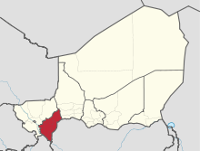 Location within Niger | |
| Coordinates: 13°03′N 3°12′E | |
| Country | |
| Capital | Dosso |
| Area | |
| • Total | 31,002 km2 (11,970 sq mi) |
| Population (2011[1]) | |
| • Total | 2,078,339 |
| • Density | 67/km2 (170/sq mi) |
| Time zone | UTC+1 (West Africa Time) |
| HDI (2017) | 0.334[2] low |
History
The region of Dosso is the historic centre of the Dosso Kingdom, which had its capital at Dosso.[4] Today the palace of the Sultanate of Dosso remains as a symbol of the aristocratic ruling class of the kingdom. The region was traditionally populated by Zarma people who are believed to have migrated from the Lake Débo area of what is now Mali during the time of the Songhai Empire.
Geography
Dosso border Tahoua Region to the northeast, Nigeria to the southeast (specifically Sokoto State and Kebbi State), Benin (Alibori Department) to the southwest, and Tillabéri Region to the northwest. The region's border with Benin is formed by the river Niger. Part of the Dallol Bosso valley runs through the region; part of this area is protected as the Dosso Reserve, and contain some of the last remaining herds of West African giraffe.[5]
Settlements
Dosso is the regional capital; other major settlements include Birni N'Gaouré, Dioundiou, Dogondoutchi, Falmey, Gaya, Loga and Tibiri (Doutchi).[6]
Administrative subdivisions
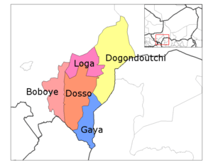
Dosso is divided into 5 Departments (Boboye Department, Dogondoutchi Department, Dosso Department, Gaya Department and Loga Department), 5 urban administrative divisions (communes urbaines) and 38 rural administrative divisions (communes rurales), 1 province, 15 cantons and 3 nomadic grouping.[7]
Demographics
Like most regions of Niger, the population of the region of Dosso has rapidly grown since independence. From 693,207 in 1977, its population increased to 1,018,895 by 1988, and to 1,479,095 by 2001. Dosso region has the third highest population density (61.4 inhabitants/km2), below that of Niamey and Maradi regions.[8] Most people live in rural areas, with only 10.4% of the population residing in urban areas.[8] Other demographic statistics are similar to the national averages.[8] The main ethnolinguistic groups are the Fulani, Hausa, Tuareg and Zarma (also referred to as 'Djerma').[9] The region is also a major centre of the Maouri, a Hausa sub-group who have retained their traditional animist belief.[5]
| Historical population | ||
|---|---|---|
| Year | Pop. | ±% |
| 1977 | 693,207 | — |
| 1985 | 1,018,895 | +47.0% |
| 2001 | 1,505,864 | +47.8% |
| 2012 | 2,037,713 | +35.3% |
| source:[10] | ||
See also
References
- Annuaire statistique du Niger
- "Sub-national HDI - Area Database - Global Data Lab". hdi.globaldatalab.org. Retrieved 2018-09-13.
- Evolution of the population by regions. National Statistics Institute of Niger (retrieved in 7/22/2014).
- Stephen Paterson Belcher (1999). Epic Traditions of Africa. Indiana University Press. pp. 164–173. ISBN 0-253-21281-2.
- Geels, Jolijn, (2006) Bradt Travel Guide - Niger, pgs. 133-42
- "Niger: Dosso - Carte Administrative (au juin 2014)" (PDF). UNOCHA. Retrieved 1 November 2019.
- Dosso in Numbers 2011. Statistics on Dosso Region (retrieved on 7/22/2014).
- "Languages of Niger". Ethnologue. Retrieved 24 October 2019.
- Niger: Administrative Division population statistics
Capital: Niamey in Niamey Capital District | |
| Agadez Region | |
| Diffa Region | |
| Dosso Region | |
| Maradi Region | |
| Tahoua Region | |
| Tillabéri Region | |
| Zinder Region | |