Adıyaman
Adıyaman (Kurdish: Semsûr[4][5]) is a Kurdish-majority[6][7] city in southeastern Turkey, capital of the Adıyaman Province. It is one of the fastest-growing cities in Turkey. The population rose from 100,045 (1990) to 202,735 in 2010.[8]
Adıyaman | |
|---|---|
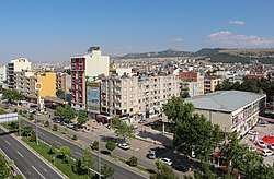 Atatürk Boulevard in Adiyaman | |
 Adıyaman | |
| Coordinates: 37°45′50″N 38°16′40″E | |
| Country | Turkey |
| Province | Adıyaman |
| Government | |
| • Mayor | Süleyman Kılınç (AKP) |
| • Governor | Aykut Pekmez [1] |
| Area | |
| • District | 1,679.21 km2 (648.35 sq mi) |
| Population (2012)[3] | |
| • Urban | 217,463 |
| • District | 273,820 |
| • District density | 160/km2 (420/sq mi) |
| Website | www.adiyaman.bel.tr |
Etymology
The city officially had the Ottoman Turkish name Hısn-ı Mansur ("Castle of Mansur") until the year 1926, named after the fortified castle perched on a hill around which the city grew. As the official name was difficult for the locals to pronounce, people were referring the city as adı yaman since early 19th century, which means "its name is tough" or "(the place) whose name is tough" in Turkish. Another likely origin of the modern Turkish name is the bad reputation that the province enjoyed due to difficult terrain and widespread banditry, hence "adı yaman", which can also translate as "(the place) which has a bad name (reputation)".[9] In 1926, this term was adopted as the official name of the city. Although the word yaman had very negative connotations in Ottoman Turkish,[10] it has earned a strong positive connotation in modern Turkish, just like the English word "terrific".
Climate
Adıyaman has a hot summer Mediterranean climate (Csa) under both the Köppen classification, and a dry-hot summer subtropical climate (Csa) under the Trewartha classification, with some continental characteristics. Summers are very hot and very dry. Temperatures often reach 40 °C (104 °F) at the height of summer. The highest recorded temperature was 45.3 °C (113.5 °F) on 30 July 2000. Winters in Adıyaman are cool to cold with heavy precipitation. Due to its inland location and relatively high altitude, frost and snow are common. The lowest recorded temperature was −14.4 °C (6.1 °F) on 24 January 1972.
| Climate data for Adıyaman (1950 - 2014) | |||||||||||||
|---|---|---|---|---|---|---|---|---|---|---|---|---|---|
| Month | Jan | Feb | Mar | Apr | May | Jun | Jul | Aug | Sep | Oct | Nov | Dec | Year |
| Record high °C (°F) | 19.9 (67.8) |
21.7 (71.1) |
28.3 (82.9) |
34.5 (94.1) |
39.0 (102.2) |
40.7 (105.3) |
45.3 (113.5) |
44.2 (111.6) |
40.3 (104.5) |
36.1 (97.0) |
29.4 (84.9) |
26.5 (79.7) |
45.3 (113.5) |
| Average high °C (°F) | 8.6 (47.5) |
10.2 (50.4) |
14.8 (58.6) |
20.5 (68.9) |
26.5 (79.7) |
33.1 (91.6) |
37.7 (99.9) |
37.5 (99.5) |
32.9 (91.2) |
25.5 (77.9) |
17.0 (62.6) |
10.6 (51.1) |
22.9 (73.2) |
| Daily mean °C (°F) | 4.5 (40.1) |
5.8 (42.4) |
10.0 (50.0) |
15.1 (59.2) |
20.6 (69.1) |
26.8 (80.2) |
31.0 (87.8) |
30.5 (86.9) |
25.6 (78.1) |
18.9 (66.0) |
11.6 (52.9) |
6.5 (43.7) |
17.2 (63.0) |
| Average low °C (°F) | 1.3 (34.3) |
2.2 (36.0) |
5.5 (41.9) |
9.8 (49.6) |
14.3 (57.7) |
19.6 (67.3) |
23.6 (74.5) |
23.3 (73.9) |
18.8 (65.8) |
13.5 (56.3) |
7.5 (45.5) |
3.2 (37.8) |
11.9 (53.4) |
| Record low °C (°F) | −14.4 (6.1) |
−10.0 (14.0) |
−7.0 (19.4) |
−2.0 (28.4) |
3.4 (38.1) |
10.6 (51.1) |
15.0 (59.0) |
15.8 (60.4) |
9.6 (49.3) |
2.2 (36.0) |
−3.5 (25.7) |
−8.4 (16.9) |
−14.4 (6.1) |
| Average precipitation mm (inches) | 133.7 (5.26) |
101.2 (3.98) |
88.3 (3.48) |
65.7 (2.59) |
42.0 (1.65) |
7.6 (0.30) |
1.0 (0.04) |
0.7 (0.03) |
5.3 (0.21) |
45.5 (1.79) |
76.3 (3.00) |
137.7 (5.42) |
705 (27.75) |
| Average precipitation days | 12.2 | 11.8 | 11.8 | 11.3 | 8.3 | 2.4 | 0.6 | 0.4 | 1.3 | 6.6 | 8.9 | 12.0 | 87.6 |
| Mean daily sunshine hours | 4.6 | 4.4 | 5.6 | 7.3 | 9.4 | 12.0 | 12.4 | 11.5 | 10.1 | 7.3 | 5.3 | 4.0 | 7.8 |
| Source: Turkish State Meteorological Service[11] | |||||||||||||
History
.jpg)
The area has been inhabited as far back as it is possible to discover. Research in the cave of Palanlı 10 km north of Adıyaman show occupation in 40,000 BC and other digs in Samsat reveal continuous occupation through the stone and Bronze Ages.
From 900BC onwards came waves of invasions from Assyrians, Persians, and Macedonians until the Armenian Commagene kingdom was founded in 69BC. This was the civilisation that built the statues on top of nearby Mount Nemrut. The capital was in Samsat (Samosata) but the town of Adıyaman was a walled city of the Commagenes. The city walls of Adıyaman have been restored and replaced many times since.
The Commagene kingdom lasted until the Romans came in 72AD. Yet more campaigns and invasions followed and Adıyaman was controlled by Byzantines 395–670, Ummayads from 670 and then Abbasids 758–926. Then the area returned to Byzantine control during 859–1114. The Arabs returned from 1114 to 1204 and finally came the arrival of the Turks. The Arabic name for the castle and town was Hısn-ı Mansur.
Turks moved into the area from 1114 onwards and for most of the 13th century was settled by the Selçuk Turks often disrupted by Mongol invasions. From 1298 to 1516 the town was under the control of the Mameluks. Adıyaman was brought into the Ottoman Empire by Selim I in 1516, but local power often rested with the Dulkadiroğulları tribe of Turkmen people that settled here.[12][13]
Adıyaman today
The city of Adıyaman provides shops and infrastructure to an agricultural region watered by the River Euphrates.The Atatürk reservoir is near the city and with more investment in irrigation, this could become a richer agricultural zone. The cuisine is typical of south-east Turkey, including dishes like çiğ köfte and Maraş-style ice-cream.
The city is served by Adıyaman Airport.
Adıyamanspor is a minor league football team.
Places of interest
.JPG)
There is some passing tourist trade, the main tourist attraction being Mount Nemrut.
- The caves of Pirin (ancient city of Perre) are 5 km (3 mi). from Adiyaman. These have been used as a burial ground for thousands of years. The sights include the ruins of the city and burial caves carved into the rock.
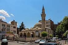
- The only active church in Adiyaman Province is located here, where it is the center of the Syriac Orthodox patriarchal vicarate of Adiyaman.[14][15] It was renovated and reopened in 2012.[16]
The ancient city of Arsameia, the summer retreat of the Kingdom of Commagene, can also be visited. Adiyaman is one of the fastest developing cities in Turkey, with many cafes, cinemas and shopping centers.
See also
References
- Müdürlüğü, Adıyaman Valiliği Bilgi İşlem Şube. "T.C. Adıyaman Valiliği". www.adiyaman.gov.tr. Archived from the original on 20 March 2018. Retrieved 24 April 2018.
- "Area of regions (including lakes), km²". Regional Statistics Database. Turkish Statistical Institute. 2002. Retrieved 2013-03-05.
- "Population of province/district centers and towns/villages by districts - 2012". Address Based Population Registration System (ABPRS) Database. Turkish Statistical Institute. Retrieved 2013-02-27.
- Ofra Bengio (2014). Kurdish Awakening: Nation Building in a Fragmented Homeland. p. 136.
- Adem Avcıkıran (2009). Kürtçe Anamnez Anamneza bi Kurmancî (PDF) (in Turkish and Kurdish). p. 56. Retrieved 17 December 2019.
- Rahman Dag (2019). Adıyaman siyasal davranış haritası (in Turkish). International Journal of Economic and Administrative Studies. p. 11. ISSN 1307-9832. Retrieved 15 March 2020.
- "FT'nin gözüyle Adıyaman: Ölümcül terör hücresini besleyen kent" (in Turkish). BBC News. 19 October 2015. Retrieved 6 February 2020.
- "adıyaman / adıyaman - Index Anatolicus". nisanyanmap.com. Retrieved 24 April 2018.
- "yaman". www.nisanyansozluk.com. Archived from the original on 24 April 2018. Retrieved 24 April 2018.
- "Meteoroloji" (in Turkish). Archived from the original on 9 January 2016. Retrieved 8 January 2016.
- "Archived copy". Archived from the original on 2016-12-02. Retrieved 2016-11-02.CS1 maint: archived copy as title (link) ADIYAMAN'IN TARİHÇESİ
- "Archived copy". Archived from the original on 2016-11-04. Retrieved 2016-11-02.CS1 maint: archived copy as title (link) Adıyaman’ın Tarihçesi
- "Mor Malki Ürek". soc-wus.org. Archived from the original on 24 April 2018. Retrieved 24 April 2018.
- location of building-37.757316, 38.273478
- "Mor Petrus-Mor Paulus Kilise'si restore edilerek ibadete açıldı! - 10-12-2012". emlakkulisi.com. Archived from the original on 4 March 2016. Retrieved 24 April 2018.
External links
| Wikimedia Commons has media related to Adıyaman. |
- Further tourist information is available at the Southeastern Anatolian Promotion Project site.
- All About Turkey
Adıyaman in Adıyaman Province of Turkey | |||||||||||||||||||||||||||
|---|---|---|---|---|---|---|---|---|---|---|---|---|---|---|---|---|---|---|---|---|---|---|---|---|---|---|---|
| Districts | 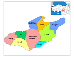 Districts of Adıyaman | ||||||||||||||||||||||||||
| |||||||||||||||||||||||||||
Metropolitan municipalities are bolded. | |||||||||||||||||||||||||||
| Authority control |
|
|---|