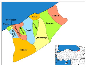
Çayeli
Çayeli (Laz: მაფავრი/Mapavri) is a town and district of Rize Province on the Black Sea coast of eastern Turkey, 18 km east of the city of Rize.
Çayeli | |
|---|---|
Town | |
 | |
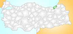 Location of Çayeli within Turkey. | |
 Çayeli Location of Çayeli within Turkey. | |
| Coordinates: 40°45′N 41°04′E | |
| Country | |
| Region | Black Sea |
| Province | Rize |
| Government | |
| • Mayor | İsmail Hakkı Çiftçi (MHP) |
| Area | |
| • District | 457.57 km2 (176.67 sq mi) |
| Elevation | 0-2,000 m (−7,000 ft) |
| Population (2012)[2] | |
| • Urban | 24,839 |
| • District | 42,206 |
| • District density | 92/km2 (240/sq mi) |
| Time zone | UTC+2 (EET) |
| • Summer (DST) | UTC+3 (EEST) |
| Postal code | 53 |
| Area code(s) | (0090)+ 464 |
| Licence plate | 53 |
| Climate | Cfa |
| Website | http://www.cayeli.bel.tr |
Çay means tea in Turkish and a large percentage of Turkey's tea is indeed grown in this lush green district.
Geography

Çayeli consists of a narrow coastal strip and a large section of the Black Sea Mountain range which rises steeply and runs parallel to the coast. The Rize mountain section of these mountains reach up to 2,000 m in the district.
The local economy is mainly dependent on tea-growing, along with some sweetcorn, which before tea was planted in the 1940s was the major crop here. The town and the cultivated area are all on the coastal strip, while the mountain hinterland is sparsely populated. Indeed, the steepness of these hills is legendary, and celebrated in song; the late Barış Manço used to sing a version of the local ballad Çayelunden Öteye Ciderum Yali Yali, which tells of a man so much in love that he was even prepared to haul his household over the mountains of Çayeli.
However, for anyone who does venture up here the countryside is unspoilt forest and the views from these steep mountainsides are incredible; therefore Çayeli is now attracting visitors on trekking holidays.
The local cuisine includes a dish of large, light-coloured baked beans known as Çayeli fasulyesi.
The majority of people are nationalist and conservative, and the municipality is controlled by the Turkish Nationalism-leaning Nationalist Movement Party.
Climate
Çayeli has a humid subtropical climate (Köppen: Cfa).
| Climate data for Çayeli | |||||||||||||
|---|---|---|---|---|---|---|---|---|---|---|---|---|---|
| Month | Jan | Feb | Mar | Apr | May | Jun | Jul | Aug | Sep | Oct | Nov | Dec | Year |
| Daily mean °C (°F) | 6.4 (43.5) |
6.7 (44.1) |
7.9 (46.2) |
11.7 (53.1) |
15.6 (60.1) |
19.4 (66.9) |
21.8 (71.2) |
22.0 (71.6) |
19.5 (67.1) |
15.5 (59.9) |
12.0 (53.6) |
8.4 (47.1) |
13.9 (57.0) |
| Average precipitation mm (inches) | 192 (7.6) |
146 (5.7) |
123 (4.8) |
83 (3.3) |
82 (3.2) |
129 (5.1) |
110 (4.3) |
144 (5.7) |
185 (7.3) |
234 (9.2) |
208 (8.2) |
215 (8.5) |
1,851 (72.9) |
| Source: Climate-Data.org[3] | |||||||||||||
History
Mapavri was long occupied by the Laz community, and was part of the Roman Empire and then the Empire of Trebizond until was brought within the Ottoman Empire by Mehmet II in 1461, although this coast has always been vulnerable to invaders from across the nearby Caucasus.
In the recent past Çayeli was an impoverished remote region that saw successive generations migrate away to jobs in Turkey's larger cities or abroad. This emigration slowed when tea was planted here in the 1940s.
See also
Neighborhoods of Çayeli
- Limanköy, Çayeli
- Demirhisar Koyu, Cayeli web site of village www.demirhisar.net
References
- "Area of regions (including lakes), km²". Regional Statistics Database. Turkish Statistical Institute. 2002. Retrieved 2013-03-05.
- "Population of province/district centers and towns/villages by districts - 2012". Address Based Population Registration System (ABPRS) Database. Turkish Statistical Institute. Retrieved 2013-02-27.
- "Climate: Çayeli". Climate-Data.org. Retrieved 14 April 2014.
External links
| Wikimedia Commons has media related to Çayeli. |
- (in Turkish) the municipality
- (in Turkish) the district governorate