Çamlıhemşin
Çamlıhemşin (Laz: ვიჯა Vica or ვიჯე Vice; Georgian: ვიჯა Vija) is a small town and district of Rize Province in the Black Sea region of Turkey.
Çamlıhemşin | |
|---|---|
Town | |
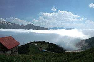 Pokut plateau. Clouds above the mountains of Rize | |
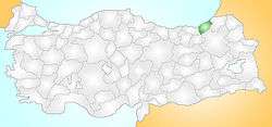 Location of Çamlıhemşin within Turkey. | |
 Çamlıhemşin Location of Çamlıhemşin within Turkey. | |
| Coordinates: 41°08′N 41°01′E | |
| Country | |
| Region | Black Sea |
| Province | Rize |
| Government | |
| • Mayor | Osman Haşimoğlu (AKP) |
| Area | |
| • District | 699.59 km2 (270.11 sq mi) |
| Elevation | 300- 700 m (985-2,300 ft) |
| Population (2012)[2] | |
| • Urban | 1,273 |
| • District | 5,976 |
| • District density | 8.5/km2 (22/sq mi) |
| Time zone | UTC+2 (EET) |
| • Summer (DST) | UTC+3 (EEST) |
| Postal code | 53 |
| Area code(s) | (0090)+ 464 |
| Licence plate | 53 |
| Climate | Cfb |
With its mountains and valleys in all shades of green, Çamlıhemşin has a reputation as one of the most attractive parts of the eastern Black Sea region, particularly with the autumn foliage.
Etymology
The town was originally known as Vija[3] or Vije, with local variants Vijealtı, Vijedibi, although it was officially named as Vicealtı until 1953 when its name was changed to Çamlıca by Turkish authorities. The name Vica (ვიჯა) [vidʒa] / Vija (ვიჟა) [viʒa] / Vice (ვიჯე) [vidʒe] is the Laz word for brine, mineral (salty) water, which corresponds to the Kartvelian *weʒ₁- form.[4] Its current name was given in 1957. This is a combination of the terms "Çamlı" which in Turkish means "pine-forested" or "piney" and "Hemşin", which is the name of the indigenous Armenian population that predominantly inhabits the region.
Geography
Çamlıhemşin is high in the Fırtına Valley, which leads down to the Black Sea coast, and is an important access point to the Kaçkar mountains. This is a hilly area surrounded by very high mountains that poke up into the clouds, and watered by the Hala River and other streams running down the Black Sea. It rains here all year round, temperatures drop to minus 7 °C in winter and reach 25 °C in summer.
This is a low-income district and successive generations of Çamlıhemşin have migrated to jobs in Turkey's larger cities (for example they have reputation as the best bakers and pastry-cooks in Ankara). In Çamlıhemşin some tea is grown and otherwise people live from forestry, beekeeping or herding animals on the mountainside. However the countryside here is a gorgeous mix of meadows and valleys and in recent years the district has begun to attract tourists, people on trekking holidays in the Kaçkar. There are now small hotels and guest houses throughout the district.
Çamlıhemşin itself is a small town of 2,355 people. There is a health centre and some blocks of public housing, residences for teachers and civil servants posted here. There are high schools in Çamlıhemşin and primary schools in the mountains villages. The traditional Çamlıhemşin village house is wooden, with a steep roof to run off the rain and a wooden terrace at the side. Many of these homes seem stuck to the steep hillsides by magic.
20 villages of the district are inhabited by Hemshinli, 7 villages are inhabited by Laz. The centre of the district (Vija/Vicealtı) has a Hemshinli majority and a Laz minority who are mostly recent settlers. Hemshinli have a distinct folk culture, for example, the women wear bright orange headscarfs which they tie in a certain way to declare their availability (or not) for marriage.
The local cuisine includes muhlama, the fondue-type hot cheese, butter and flour pudding.
Climate
Çamlıhemşin has an oceanic climate (Köppen: Cfb).
| Climate data for Çamlıhemşin | |||||||||||||
|---|---|---|---|---|---|---|---|---|---|---|---|---|---|
| Month | Jan | Feb | Mar | Apr | May | Jun | Jul | Aug | Sep | Oct | Nov | Dec | Year |
| Daily mean °C (°F) | 3.8 (38.8) |
4.4 (39.9) |
6.6 (43.9) |
10.8 (51.4) |
14.7 (58.5) |
18.4 (65.1) |
21.2 (70.2) |
21.3 (70.3) |
18.6 (65.5) |
14.1 (57.4) |
10.0 (50.0) |
5.9 (42.6) |
12.5 (54.5) |
| Average precipitation mm (inches) | 141 (5.6) |
109 (4.3) |
94 (3.7) |
77 (3.0) |
77 (3.0) |
109 (4.3) |
87 (3.4) |
108 (4.3) |
138 (5.4) |
177 (7.0) |
159 (6.3) |
164 (6.5) |
1,440 (56.8) |
| Source: Climate-Data.org[5] | |||||||||||||
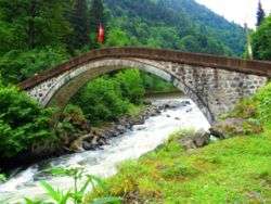
Places of interest

Çamlıhemşin has a number of places for hiking and escaping into the countryside, including:
Notable residents
- Mahmut Turan - player of the tulum, a kind of bagpipes
References
- "Area of regions (including lakes), km²". Regional Statistics Database. Turkish Statistical Institute. 2002. Retrieved 2013-03-05.
- "Population of province/district centers and towns/villages by districts - 2012". Address Based Population Registration System (ABPRS) Database. Turkish Statistical Institute. Retrieved 2013-02-27.
- Mohti Rize Fındıklı lazlar çamlıhenşin horon Lazca google Kadir Kalemci Web Sayfası Maşukiye Laz Mehmet
- Gogokhia, Bakur, "About the name of Vija town in Lazeti", Etymological Researches XI, Arnold Chikobava Institute of Linguistics, Tbilisi, 2014, p.p. 3-10; ISSN 1987-9946 (in Georgian).
- "Climate: Çamlıhemşin". Climate-Data.org. Retrieved 14 April 2014.
External links
- (in English) Çamlıhemşin with photographs
- (in Turkish) Gulapoğlu Ailesi Sitesi - Gulapoglu Family Site from Camlihemsin
- (in Turkish) the Çamlıhemşin-Hemşin foundation
- (in English) a forum for discussion of all things Hamsheni
- (in Turkish) website tilted "WE ARE HEMŞİNLİ"
Çamlıhemşin in Rize Province of Turkey | |||||||||||||||||||||||||||
|---|---|---|---|---|---|---|---|---|---|---|---|---|---|---|---|---|---|---|---|---|---|---|---|---|---|---|---|
| Districts | 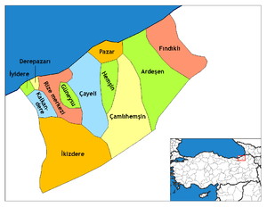 Districts of Rize | ||||||||||||||||||||||||||
| |||||||||||||||||||||||||||
Metropolitan municipalities are bolded. | |||||||||||||||||||||||||||