Zhari Namco
| Zhari Namco | |
|---|---|
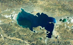 Satellite Image of Zhari Namco | |
| Coordinates | 30°55′N 85°38′E / 30.917°N 85.633°ECoordinates: 30°55′N 85°38′E / 30.917°N 85.633°E |
| Type | Endorheic, Saline, Permanent, Natural |
| Primary inflows | Cuoqin Zangbu, Dalong Zangbu |
| Catchment area | 15,433.2 km2 (5,958.8 sq mi) |
| Basin countries | China |
| Max. length | 54.3 km (34 mi) |
| Max. width | 26.2 km (16 mi) |
| Surface area | 996.9 km2 (400 sq mi) |
| Shore length1 | 183 km (100 mi) |
| Surface elevation | 4,613 m (15,135 ft) |
| 1 Shore length is not a well-defined measure. | |
Zhari Namco or Zhari Nanmu or Lake Trari Nam (Tibetan: བཀྲ་རི་གནམ་མཚོ, Wylie: bkra ri gnam mtsho , Chinese: 扎日南木错) is a salt lake in Tibet, it is bounded on the west by the Ngari Prefecture of Coqên County, and on the east by the Ngamring County of Shigatse Prefecture. Zhari Namco is 996.9 square kilometres (384.9 sq mi), with a drainage area of 15,433.2 square kilometres (5,958.8 sq mi), an elevation of 4,613 metres (15,135 ft), length 54.3 kilometres (33.7 mi) and mean width 18.36 kilometres (11.41 mi) (maximum width 26.2 kilometres [16.3 mi]).[1] It is located east of Coqên Town in southern Tibet.[2]
Climate
| Climate data for Zhari Namco | |||||||||||||
|---|---|---|---|---|---|---|---|---|---|---|---|---|---|
| Month | Jan | Feb | Mar | Apr | May | Jun | Jul | Aug | Sep | Oct | Nov | Dec | Year |
| Average high °C (°F) | −2.7 (27.1) |
−1.0 (30.2) |
2.2 (36) |
7.1 (44.8) |
10.9 (51.6) |
14.9 (58.8) |
14.7 (58.5) |
13.9 (57) |
12.0 (53.6) |
7.3 (45.1) |
1.2 (34.2) |
−1.3 (29.7) |
6.6 (43.9) |
| Daily mean °C (°F) | −9.7 (14.5) |
−8.1 (17.4) |
−4.4 (24.1) |
−0.5 (31.1) |
3.1 (37.6) |
7.6 (45.7) |
8.8 (47.8) |
8.3 (46.9) |
5.7 (42.3) |
−0.1 (31.8) |
−5.8 (21.6) |
−8.4 (16.9) |
−0.3 (31.5) |
| Average low °C (°F) | −16.7 (1.9) |
−15.2 (4.6) |
−10.9 (12.4) |
−8.1 (17.4) |
−4.7 (23.5) |
0.4 (32.7) |
2.9 (37.2) |
2.7 (36.9) |
−0.5 (31.1) |
−7.4 (18.7) |
−12.7 (9.1) |
−15.5 (4.1) |
−7.1 (19.1) |
| Average precipitation mm (inches) | 13 (0.51) |
8 (0.31) |
15 (0.59) |
11 (0.43) |
8 (0.31) |
15 (0.59) |
53 (2.09) |
59 (2.32) |
24 (0.94) |
10 (0.39) |
1 (0.04) |
5 (0.2) |
222 (8.72) |
| Source: Climate-Data.org | |||||||||||||
Notes
- ↑ Sumin, Wang; Hongshen, Dou (1998). Lakes in China. Beijing: Science Press. p. 399. ISBN 7-03-006706-1.
- ↑ Maps (Map). Google Maps.
| Five Great Lakes | ||
|---|---|---|
| Notable freshwater lakes |
| |
| Notable salt lakes | ||
| National Parks |
| |
| Protected wetlands | ||
| Nature Reserves | ||
| Major urban lakes | ||
| Reservoirs |
| |
| County-level divisions | 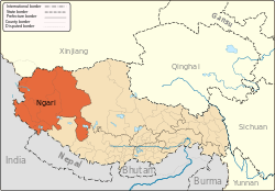 | |
|---|---|---|
| Towns and villages | ||
| Geography | ||
| Landmarks | ||
This article is issued from
Wikipedia.
The text is licensed under Creative Commons - Attribution - Sharealike.
Additional terms may apply for the media files.