Zádveřice-Raková
| Zádveřice-Raková | |||
|---|---|---|---|
| Municipality | |||
 Zádveřice | |||
| |||
 Zádveřice-Raková | |||
| Coordinates: 49°12′53″N 17°48′41″E / 49.21472°N 17.81139°ECoordinates: 49°12′53″N 17°48′41″E / 49.21472°N 17.81139°E | |||
| Country |
| ||
| Region | Zlín | ||
| District | Zlín | ||
| Area | |||
| • Total | 17.96 km2 (6.93 sq mi) | ||
| Elevation | 264 m (866 ft) | ||
| Population (2006) | |||
| • Total | 1,341 | ||
| • Density | 75/km2 (190/sq mi) | ||
| Postal code | 763 12 | ||
| Website | http://www.zadverice.cz | ||

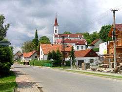
Zádveřice-Raková is a village and municipality (obec) in Zlín District in the Zlín Region of the Czech Republic.
The municipality covers an area of 17.96 square kilometres (6.93 sq mi), and has a population of 1,341 (as at 3 July 2006).
Zádveřice-Raková lies approximately 11 kilometres (7 mi) east of Zlín and 263 km (163 mi) east of Prague.
Gallery
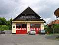 Municipal office and the fire brigade
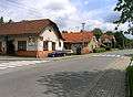 Restaurant
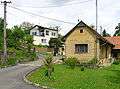 Local part Raková
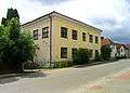 Old school building
References
| Wikimedia Commons has media related to Zádveřice-Raková. |
This article is issued from
Wikipedia.
The text is licensed under Creative Commons - Attribution - Sharealike.
Additional terms may apply for the media files.