Lípa (Zlín District)
| Lípa | |||
|---|---|---|---|
| Municipality | |||
 | |||
| |||
 Lípa | |||
| Coordinates: 49°12′18″N 17°46′23″E / 49.20500°N 17.77306°ECoordinates: 49°12′18″N 17°46′23″E / 49.20500°N 17.77306°E | |||
| Country |
| ||
| Region | Zlín | ||
| District | Zlín | ||
| Area | |||
| • Total | 8.34 km2 (3.22 sq mi) | ||
| Elevation | 249 m (817 ft) | ||
| Population (2006) | |||
| • Total | 717 | ||
| • Density | 86/km2 (220/sq mi) | ||
| Postal code | 763 11 | ||
| Website | http://www.lipa.czobce.info | ||
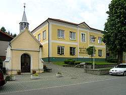
Lípa (also known as Lípa nad Dřevnicí) is a village and municipality (obec) in Zlín District in the Zlín Region of the Czech Republic.
The municipality covers an area of 8.34 square kilometres (3.22 sq mi), and has a population of 717 (as at 3 July 2006).
Lípa lies on the Dřevnice river, approximately 9 kilometres (6 mi) east of Zlín and 261 km (162 mi) east of Prague.
Gallery
 East part
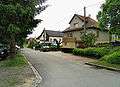 South part
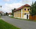
References
| Wikimedia Commons has media related to Lípa (Zlín District). |
This article is issued from
Wikipedia.
The text is licensed under Creative Commons - Attribution - Sharealike.
Additional terms may apply for the media files.