Spytihněv (Zlín District)
| Spytihněv | |||
|---|---|---|---|
| Municipality | |||
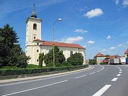 Church of the Assumption of the Virgin Mary | |||
| |||
 Spytihněv | |||
| Coordinates: 49°8′36″N 17°29′40″E / 49.14333°N 17.49444°ECoordinates: 49°8′36″N 17°29′40″E / 49.14333°N 17.49444°E | |||
| Country |
| ||
| Region | Zlín | ||
| District | Zlín | ||
| Area | |||
| • Total | 9.64 km2 (3.72 sq mi) | ||
| Elevation | 186 m (610 ft) | ||
| Population | |||
| • Total | 1,677 | ||
| • Density | 170/km2 (450/sq mi) | ||
| Postal code | 763 64 | ||
| Website | http://www.spytihnev.cz | ||


Spytihněv is a village and municipality (obec) in Zlín District in the Zlín Region of the Czech Republic.
The municipality covers an area of 9.64 square kilometres (3.72 sq mi), and has a population of 1,677.
Spytihněv lies approximately 17 kilometres (11 mi) south-west of Zlín and 246 km (153 mi) south-east of Prague.
Gallery
 Municipal office
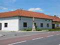 Statue of John the Evangelist
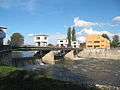 Weir on the Morava River
 Molo on the Baťa canal
References
This article is issued from
Wikipedia.
The text is licensed under Creative Commons - Attribution - Sharealike.
Additional terms may apply for the media files.