Petrůvka
| Petrůvka | |||
|---|---|---|---|
| Municipality | |||
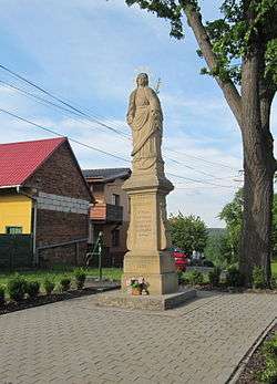 Statue of the Immaculate Virgin Mary | |||
| |||
 Petrůvka | |||
| Coordinates: 49°6′17″N 17°48′36″E / 49.10472°N 17.81000°ECoordinates: 49°6′17″N 17°48′36″E / 49.10472°N 17.81000°E | |||
| Country |
| ||
| Region | Zlín | ||
| District | Zlín | ||
| Area | |||
| • Total | 7.02 km2 (2.71 sq mi) | ||
| Elevation | 484 m (1,588 ft) | ||
| Population | |||
| • Total | 364 | ||
| • Density | 52/km2 (130/sq mi) | ||
| Postal code | 763 21 | ||
| Website | http://www.obecpetruvka.cz | ||
Petrůvka is a village and municipality (obec) in Zlín District in the Zlín Region of the Czech Republic.
The municipality covers an area of 7.02 square kilometres (2.71 sq mi), and has a population of 364.
Petrůvka lies approximately 18 kilometres (11 mi) south-east of Zlín and 268 km (167 mi) south-east of Prague.
References
This article is issued from
Wikipedia.
The text is licensed under Creative Commons - Attribution - Sharealike.
Additional terms may apply for the media files.