Štítná nad Vláří-Popov
| Štítná nad Vláří-Popov | |||
|---|---|---|---|
| Municipality | |||
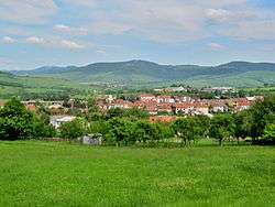 View of the village from the west; White Carpathians in the background | |||
| |||
 Štítná nad Vláří-Popov | |||
| Coordinates: 49°3′48″N 17°58′24″E / 49.06333°N 17.97333°ECoordinates: 49°3′48″N 17°58′24″E / 49.06333°N 17.97333°E | |||
| Country |
| ||
| Region | Zlín | ||
| District | Zlín | ||
| Area | |||
| • Total | 28.4 km2 (11.0 sq mi) | ||
| Elevation | 318 m (1,043 ft) | ||
| Population (2006) | |||
| • Total | 2,367 | ||
| • Density | 83/km2 (220/sq mi) | ||
| Postal code | 763 33 | ||
| Website | http://www.stitna-popov.cz | ||


Štítná nad Vláří-Popov is a village and municipality (obec) in Zlín District in the Zlín Region of the Czech Republic.
The municipality covers an area of 28.4 square kilometres (11.0 sq mi), and has a population of 2,367 (as at 28 August 2006).
Štítná nad Vláří-Popov lies approximately 30 kilometres (19 mi) south-east of Zlín and 281 km (175 mi) south-east of Prague.
References
| Wikimedia Commons has media related to Štítná nad Vláří-Popov. |
This article is issued from
Wikipedia.
The text is licensed under Creative Commons - Attribution - Sharealike.
Additional terms may apply for the media files.