Jantar Mantar, New Delhi
| Jantar Mantar, New Delhi | |
|---|---|
| Jantaram Mantaram | |
.jpg) Misra Yantra at Jantar Mantar | |
| Type | Observatory |
| Location | New Delhi, India |
| Nearest city | New Dehli |
| Coordinates | 28°37′26″N 77°12′57″E / 28.624000°N 77.215938°E |
| Height |
723 ft 9.039 in |
| Founder | Maharaja Jai Singh II |
| Built | 1724 |
| Website | Official website |
 Location of Jantar Mantar, New Delhi in Delhi  Jantar Mantar, New Delhi (India) | |
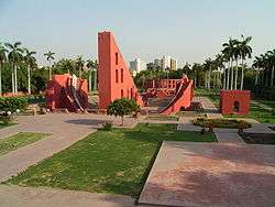
Jantar Mantar is located in the modern city of New Delhi. It consists of 13 architectural astronomy instruments. The site is one of five built by Maharaja Jai Singh II of Jaipur, from 1723 onwards, as he was given by Mughal emperor Muhammad Shah the task of revising the calendar and astronomical tables. There is a plaque fixed on one of the structures in the Jantar Mantar observatory in New Delhi that was placed there in 1910 mistakenly dating the construction of the complex to the year 1710. Later research, though, suggests 1724 as the actual year of construction.
The primary purpose of the observatory was to compile astronomical tables, and to predict the times and movements of the sun, moon and planets. Some of these purposes nowadays would be classified as astronomy.
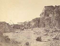
Completed in 1724, the Delhi Jantar Mantar had decayed considerably by 1867.The Ram yantra, The samrat Yantra, Jayprakash yantra and The mishra yantras are the distinct instruments of Jantar Mantar.
Purpose of individual structures
The 4 distinct instruments within the observatory of Jantar Mantar in New Delhi: the Samrat Yantra, the Jayaprakash, Rama Yantra and the Misra Yantra.
- Samrat Yantra: The Samrat Yantra, or Supreme Instrument, is a giant triangle that is basically an equal hour sundial. It is 70 feet high, 114 feet long at the base, and 10 feet thick. It has a 128-foot-long (39 m) hypotenuse that is parallel to the Earth's axis and points toward the North Pole. On either side of the triangle is a quadrant with graduations indicating hours, minutes, and seconds. At the time of the Samrat Yantra's construction, sundials already existed, but the Samrat Yantra turned the basic sundial into a precision tool for measuring declination and other related coordinates of various heavenly bodies.
- Jayaprakash Yantra: The Jayaprakash consists of hollowed out hemispheres with markings on their concave surfaces. Crosswires were stretched between points on their rim. From inside the Ram, an observer could align the position of a star with various markings or a window's edge.
- Rama Yantra: Two large cylindrical structures with open top, used to measure the altitude of stars based on the latitude and the longitude on the earth.
- Misra Yantra: The Misra Yantra (literally mixed instrument) is a composite of 5 instruments designed as a tool to determine the shortest and longest days of the year. It could also be used to indicate the exact moment of noon in various cities and locations regardless of their distance from Delhi. The Mishra yantras were able to indicate when it was noon in various cities all over the world and was the only structure in the observatory not invented by Jai Singh II.
Other observatories
Between 1727 and 1734 Jai Singh II built five similar observatories in west-central India, all known by the name Jantar Mantar. They are located at
While the purpose of the Jantar Mantars was astronomy and astrology (Jyotish), they are also a major tourist attraction and a significant monument of the history of astronomy.
[[]]
Picture gallery
.jpg) West tower of Samrat Yantra
West tower of Samrat Yantra.jpg) Centre tower Samrat Yantra
Centre tower Samrat Yantra.jpg) East tower Samrat Yantra
East tower Samrat Yantra.jpg) Rama Yantra (North of the two Rama Yantras)
Rama Yantra (North of the two Rama Yantras).jpg) Inside view of Rama Yantra 2 of Jantar Mantar
Inside view of Rama Yantra 2 of Jantar Mantar Plaque at Jantar Mantar, Delhi (Zoom in to read)
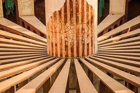 Inside view of Rama Yantra of Jantar Mantar Closeup
 Inside view of Rama Yantra of Jantar Mantar Details
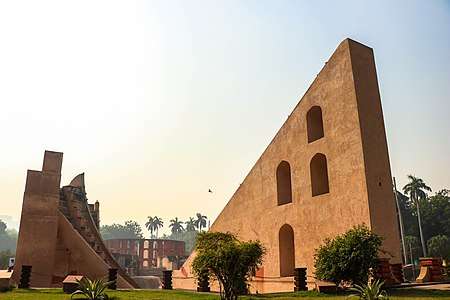 Shastansh Yantra - East Side
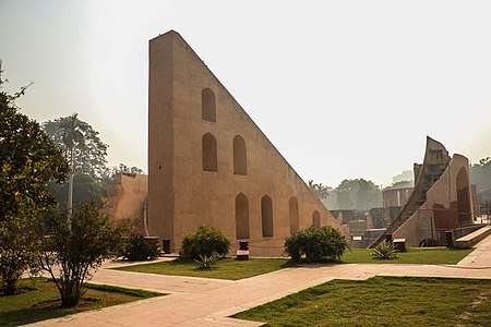 Shastansh Yantra - West Side
See also
References
- Introduction www.jantarmantar.org.
- Awake (2005). Jantar Mantar An Observatory Without Telescopes. Awake,86 (13),18-20.
- Jantar Mantar British Library
Further reading
- Comprehensive report on history and instrument design at Jantar Mantar
- Sharma, Virendra Nath (1995). Sawai Jai Singh and his astronomy. Motilal Banarsidass Publishers Pvt. Ltd. ISBN 81-208-1256-5.
- Articles on Jantar Mantar
External links
| Wikimedia Commons has media related to Jantar Mantar (Delhi). |
- Jantar Mantar - The Astronomical Observatories of Jai Singh II
- Observations on Jantar Mantar in New Delhi
- Step Inside Jantar Mantar in New Delhi
- Architectural Astronomy Instruments (video in English)
- Jantar Mantar—An Observatory Without Telescopes (in English)
- जंतर मंतर—बगैर टेलिस्कोप की वेधशाला (in Hindi)
Coordinates: 28°37′37.59″N 77°12′59.32″E / 28.6271083°N 77.2164778°E