Yantian District
| Yantian 盐田区 | |
|---|---|
| District | |
 Yantian Port Area | |
 Yantian District (highlighted in blue) in Shenzhen | |
| Country | People's Republic of China |
| Province | Guangdong |
| Sub-provincial city | Shenzhen |
| Area | |
| • Total | 72.63 km2 (28.04 sq mi) |
| Population (2017) | |
| • Total | 237,200 |
| • Density | 3,300/km2 (8,500/sq mi) |
| Time zone | UTC+8 (China Standard) |
| Postal code | 518083 |
| Area code | 0755 |
| Licence plates | 粤B |
| Website |
www |
Yantian District (simplified Chinese: 盐田区; traditional Chinese: 鹽田區; pinyin: Yántián Qū; Jyutping: Jim4tin4 Keoi1) is one of the nine districts of the city of Shenzhen, Guangdong, China. It is adjacent to Shenzhen River and Hong Kong to the south, and is surrounded by Luohu, Longgang and Pingshan districts of Shenzhen.
Before 1960s, the northern part of the district belonged to Huiyang County(now Huiyang District, Huizhou). The famous Huizhou Uprising launched by Dr. Sun Yat-sen started in the northern part of the district during 1900. The failure of the revolution had inspired Dr. Sun to revolt against the Qing Imperial. Qing Dynasty soon ended in 1912 after the Wuchang Uprising.
Due to the proximity to Bao'an County, Northern Yantian merged into the new County in 1960s. In 1978, after the establishment of Shenzhen Special Economic Zone(SEZ), Yantian(as a part of Luohu District), together with several other districts in Bao'an County, formed the new special economic district. In March 1998, Yantian separated from Luohu District after the construction of Yantian Port Area of Shenzhen Port.
Subdistricts
The size of Yantian district is about 72.63 km2 (28.04 sq mi), divided into four subdistricts:
| Name | Chinese (S) | Hanyu Pinyin | Canton Romanization | Population (2010)[1] | Area (km2) |
|---|---|---|---|---|---|
| Haishan Subdistrict | 海山街道 | Hǎishān Jiēdào | hoi2 san1 gai1 dou6 | 61,858 | 5.52 |
| Yantian Subdistrict | 盐田街道 | Yántián Jiēdào | yim4 tin4 gai1 dou6 | 80,641 | 17.8 |
| Meisha Subdistrict | 梅沙街道 | Méishā Jiēdào | mui4 sa1 gai1 dou6 | 18,063 | 16.83 |
| Shatoujiao Subdistrict | 沙头角街道 | Shātóujiǎo Jiēdào | sa1 teo4 gog3 gai1 dou6 | 48,798 | 6.91 |
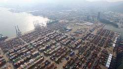
Located on Mirs Bay, Yantian is the location of some of Shenzhen's best-known tourist beaches, Dameisha and Xiaomeisha. Yantian Port Area is also located within the district.[2]
Economy
Industrial zone
The Shenzhen Yantian Port Free Trade Zone was set up and approved by the State Council on September 27, 1996 with a total area of 0.85 square kilometer. On August 16, 2004, the project of "zone-port interaction" was approved by the State Council between Yantian Port Area and the Shenzhen Yantian Port Free Trade Zone.
Yantian Port Bonded Logistics Park was established with 0.96 square kilometer on December 30, 2005. The zone is situated near Yantian Port Area. Industries that are encouraged include printing/publishing/packaging, raw material processing, shipping/warehousing/logistics, and trading and distribution.[3]
Tourist attractions
- Chung Ying Street(中英街)
- Wutongshan National Park (梧桐山國家森林公園/梧桐山国家森林公园)
- Dameisha Beach (大梅沙)
- Xiaomeisha Beach (小梅沙)
- Shenzhen Xiaomeisha Sea World[4] (小梅沙海洋世界)
- OCT East[5] (東部華僑城/东部华侨城)
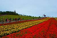 Flower Field in OCT East
 Xiaomeisha Beach
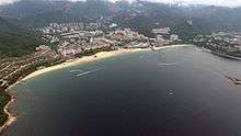 Dameisha beach
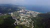 Dameisha as viewed from OCT East
Transportation
The main bus routes covering Yantian District are shown on the table below. Moreover, there is a ferry between Yantian Seafood Street and Nan'ao, Dapeng New District. The proposed Shenzhen Metro Yantian Line will be built to help serve the area.
| Route No. | Terminal 1 | Terminal 2 | Fare | Note |
|---|---|---|---|---|
| 68 | Shenzhen Foreign Language School | Shatoujiao Bus Terminal | 2 RMB | |
| 85 | Yantian N. Bus Terminal | W. Square of Shenzhen E. Railway Station | 2-5 RMB | |
| 103 | Xiasha Terminal | Xiaomeisha Terminal | 2-8 RMB | |
| 205 | Yantian N. Bus Terminal | Railway Station | 3 RMB | |
| 308 | Wentan Rd. Depot | Sanlian Terminal | 2-6 RMB | |
| 358 | Funing Terminal | Shatoujiao Bus Terminal | 2-6 RMB | |
| 387 | Xiaomeisha Terminal | Railway Station | 2-6 RMB | |
| B619 | Shatoujiao Bus Terminal | Shatoujiao Bus Terminal | 1 RMB | Clockwise loop |
| B626 | Shenzhen Foreign Language School | Yantian Seafood St. | 1 RMB | |
| B701 | Shatoujiao Bus Terminal | Jimei Industrial Area | 1 RMB | |
| B843 | Yiwu Domestic Trading Town | Yiwu Domestic Trading Town | 1 RMB | Unidirectional 8-shaped loop |
| B902 | Shatoujiao Bus Terminal | Shatoujiao Community Health Care Center | 1 RMB | |
| B924 | Yantian E. Bus Terminal | Zhongying Street Border Station | 1 RMB | |
| B925 | Yantian E. Bus Terminal | Vanke the Palace | 1 RMB | |
| B961 | Dameisha Depot | Zhongying Street Border Station | 1 RMB | |
| B982 | Vanke the Palace | Xiangjing S. St. | 1 RMB | |
| E11 | Xinda Terminal | Shenzhen N. Railway Station | 10 RMB | |
| E12 | Wentan Rd. Depot | Xiangmei N. Terminal | 7 RMB | |
| E26 | Dapeng Intercity Bus Station | Futian Transport Hub | 10 RMB | |
| M180 | Shuitian New Energy Depot | Xiaomeisha Terminal | 2-10 RMB | |
| M191 | Bao'an Transit Center | Dameisha Depot | 2-10 RMB | |
| M290 | Yantian N. Bus Terminal | Guomao | 3 RMB | |
| M314 | Universiade Metro Station | Shatoujiao Bus Terminal | 3 RMB | |
| M348 | Shenzhen Foreign Language School | Tianbei Terminal | 3 RMB | |
| M396 | Kengzi Intercity Bus Station | Xiaomeisha Terminal | 2-10 RMB | |
| M437 | Wentan Rd. Depot | Minle Metro Station | 2-7 RMB | |
| M438 | Wentan Rd. Depot | Beizaijiao | 2 RMB | |
| M444 | Vanke the Ville Bus Terminal | Shatoujiao Bus Terminal | 2 RMB | |
| M465 | Vanke the Ville Bus Terminal | Wentan Rd. Depot | 2 RMB | |
| M520 | Wentan Rd. Depot | Futian Transport Hub | 3 RMB | |
| M526 | Airport New Terminal | Wentan Rd. Depot | 2-10 RMB |
References
- ↑ shi, Guo wu yuan ren kou pu cha ban gong; council, Guo jia tong ji ju ren kou he jiu ye tong ji si bian = Tabulation on the 2010 population census of the people's republic of China by township / compiled by Population census office under the state; population, Department of; statistics, employment statistics national bureau of (2012). Zhongguo 2010 nian ren kou pu cha fen xiang, zhen, jie dao zi liao (Di 1 ban. ed.). Beijing Shi: Zhongguo tong ji chu ban she. ISBN 978-7-5037-6660-2.
- ↑ "{title}". Archived from the original on 2008-12-24. Retrieved 2008-11-28.
- ↑ "RightSite.asia - Shenzhen Yantian Port Free Trade Zone".
- ↑ 深圳市特发小梅沙旅游中心. "小梅沙|深圳小梅沙|小梅沙海洋世界|深圳小梅沙海洋公园|深圳海洋世界|深圳市特发小梅沙旅游中心". www.szxms.com.cn.
- ↑ "{title}". Archived from the original on 2008-12-02. Retrieved 2008-11-28.
External links
| Wikimedia Commons has media related to Yantian District. |
- Yantian Government Online (in Chinese)
.svg.png)
| Sub-provincial cities |
| ||||||||||||||||||||||||||||||||||||||||||||||||||||||||||||||||
|---|---|---|---|---|---|---|---|---|---|---|---|---|---|---|---|---|---|---|---|---|---|---|---|---|---|---|---|---|---|---|---|---|---|---|---|---|---|---|---|---|---|---|---|---|---|---|---|---|---|---|---|---|---|---|---|---|---|---|---|---|---|---|---|---|---|
| Prefecture-level cities |
| ||||||||||||||||||||||||||||||||||||||||||||||||||||||||||||||||
| |||||||||||||||||||||||||||||||||||||||||||||||||||||||||||||||||
Coordinates: 22°33′49″N 114°14′24″E / 22.5637°N 114.24°E