Xiangyang

.png)

Xiangyang is a prefecture-level city in northwestern Hubei province, People's Republic of China. It was known as Xiangfan until December 2, 2010.[2] Xiangyang is divided by the Han River, which runs through its heart and divides the city north-south. The city itself is an incorporation of two once separate, ancient cities: Fancheng and Xiangcheng District. What remains of old Xianyang is located south of the Han River and contains one of the oldest still-intact city walls in China while Fancheng was located to the north of the Han River. Both cities served prominent historical roles in both the Ancient and Pre-Modern Periods of Chinese history. Today, the city is, after the capital Wuhan, the second largest in the province, located about halfway between Wuhan and Xi'an. It is considered one of the third tier cities in China and has been a target of government and private investment as the country seeks to urbanize and develop the interior provinces.
Its built-up area made up of 3 urban districts had 2,199,689 inhabitants at the 2010 census while the whole municipality contained approximately 5,500,307 people.
History

Xiangfan has a history of over 2800 years. It was the location of major battles during the Three Kingdoms period in 191 A.D. between Sun Jian and Liu Biao and in 1267-1273 A.D. between the Southern Song and the Mongols.
Its major scenic spots and cultural sites include Xiangyang City Moat, the Pseudo-classic Street, Ancient Longzhong, Memorial Temple to Mi Fu, Lumen Temple.
The wall of Xiangfan city is very old, but the condition is fine now. The region's premier tourist attractions are Dahongshan scenic area and some historical relics, including the Lumenshan relic, the Zhanggongci Temple, the Cheng' en Monastery, and the Baishui Monastery.
Geography
Xiangyang has a latitude range of 31° 14'−32° 37' N, or 154 km (96 mi), and longitude range of 110° 45'−113° 43' E, or 220 km (137 mi), and is located on the middle reaches of the Hanshui, a major tributary of the Yangtze River. The urban area, however, has a latitude range of 31° 54'−32° 10' N, or 29 km (18 mi), and longitude range of 112° 00'−112° 14' E, or 21 km (13 mi). It borders Suizhou to the east, Jingmen and Yichang to the south, Shennongjia and Shiyan to the west, and Nanyang (Henan) to the north. Its administrative border has a total length of 1,332.8 km (828.2 mi).
Xiangyang has a monsoon-influenced, four season humid subtropical climate (Köppen Cfa), with cold, damp (but comparatively dry), winters, and hot, humid summers.
Administration
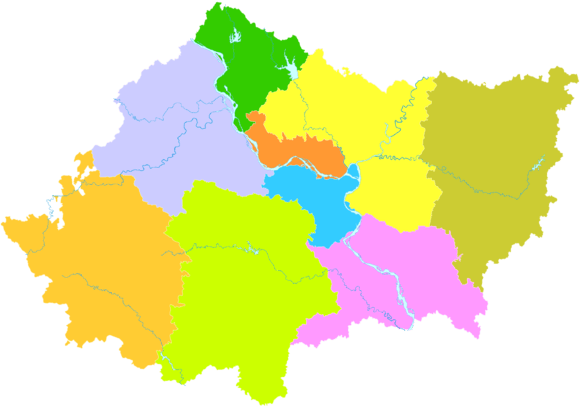
The prefecture-level city of Xiangyang administers 9 county-level divisions, including 3 districts, 3 county-level cities and 3 counties.[3][4]
- Xiangzhou District (襄州区)
- Xiangcheng District (襄城区)
- Fancheng District (樊城区)
- Zaoyang City (枣阳市)
- Yicheng City (宜城市)
- Laohekou City (老河口市)
- Nanzhang County (南漳县)
- Gucheng County (谷城县)
- Baokang County (保康县)
These are further divided into 159 township-level divisions, including 106 towns, 29 townships and 24 subdistricts.
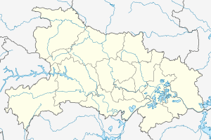
| Map |
|---|
Economy

Xiangyang possesses large water energy resources whilst its mineral deposits include rutile, ilmenite, phosphorus, barite, coal, iron, aluminum, gold, manganese, nitre, and rock salt. The reserves of rutile and ilmenite rank highly in China. Textile production is the mainstay industry of Xiangfan followed by machinery manufacture, chemical processing, electronics, and manufacture of construction materials. Agricultural resources are significant with Xiangfan's chief farm products including grain, cotton, vegetable oil crops, tobacco, tea and fruit. As the home of Dongfeng Motors, Xiangfan is a well known automobile hub and partners with foreign manufacturers to produce Nissan and Infiniti models for domestic sales. In addition, there are a number of chemical fibre enterprises in the city including Birla Jingwei Fibres, a member of the Aditya Birla Group. The city has also invested in many industrial, technology and clean energy parks.
Transportation
Rail and highway transportation facilities in Xiangfan are very good. Xiangfan is a railway junction for the Xiangfan-Chongqing (Xiangyu), Hankou-Danjiangkou (Handan), and Jiaozuo-Liuzhou (Jiaoliu) Railways. Three National Highways including Route 207 pass through the city. The Han River and four other rivers are open to commercial navigation year-round. The Xiangfan Airport has commercial airline service to major cities throughout China including Beijing, Shanghai, and Guangzhou.
References
- ↑ "China: Húbĕi (Prefectures, Cities, Districts and Counties) - Population Statistics, Charts and Map". www.citypopulation.de. Retrieved 5 April 2018.
- ↑ 湖北省襄樊市更名为襄阳市(图) (in Chinese). 163.com. 2010-12-02. Retrieved 2010-12-03.
- ↑ 襄樊市更名为襄阳市,襄阳区更名为襄州区 [Xiangfan City Changes Name to Xiangyang City, Xiangyang District Changes Name to Xiangzhou District]. 行政区划网站 www.xzqh.org (in Simplified Chinese). 行政区划网站/区划地名网站 (Administrative Divisions Web/District Geographic Names Web). 2 December 2010. Retrieved 22 August 2018.
行政区划调整后,襄阳市辖襄城、樊城、襄州3个市辖区以及南漳、谷城、保康3个县,代管老河口、枣阳、宜城3个县级市。
- ↑ 2017年统计用区划代码和城乡划分代码:襄阳市 [2017 Statistical Area Numbers and Rural-Urban Area Numbers: Xiangyang City]. National Bureau of Statistics of the People's Republic of China. 2017. Retrieved 22 August 2018.
统计用区划代码 名称 420601000000 市辖区 420602000000 襄城区 420606000000 樊城区 420607000000 襄州区 420624000000 南漳县 420625000000 谷城县 420626000000 保康县 420682000000 老河口市 420683000000 枣阳市 420684000000 宜城市
External links
| Wikimedia Commons has media related to Xiangfan. |