Wyre Light (Fleetwood)
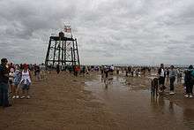 The derelict Wyre Light in 2006 | |
 Borough of Wyre | |
| Location |
offshore Fleetwood Lancashire England United Kingdom |
|---|---|
| Coordinates | 53°57′11″N 3°01′37″W / 53.953°N 3.027°WCoordinates: 53°57′11″N 3°01′37″W / 53.953°N 3.027°W |
| Year first constructed | 1840 |
| Deactivated | 1979[1] |
| Foundation | wrought iron piles |
| Construction | cast iron screw-pile lighthouse |
| Tower shape | hexagonal frustum structure with platform, keeper’s quarter and lantern |
| Height | 4.9 metres (16 ft) (piles) |
| Focal height | 14 metres (46 ft) (above half tide level) |
| Range | 8 nautical miles (15 km; 9.2 mi)[2] |
| Admiralty number | ex A4888 |
| ARLHS number | ENG-171[3] |
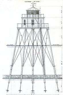
The Wyre Light was a 40-foot (12 m) tall iron screw-pile lighthouse marking the navigation channel to the town of Fleetwood, Lancashire, England.
History
The lighthouse was designed by Alexander Mitchell, an Irish engineer who developed the screwpile concept. It was the first screwpile lighthouse ever to be lit. Although construction of the Maplin Sands Light on the northern bank of the Thames estuary had started before Wyre Light, the latter was completed in a much shorter period of time.[4] These lights inspired other similar constructions such as the Thomas Point Shoal Light in the United States.
The 'Wyre Light' stood 2 nautical miles (3.7 km) offshore on the 'North Wharf Bank', sandbanks which mark the 'Lune Deep' and the navigation channel of the Wyre. The Wyre Light along with a pair of on shore lighthouses, the Beach Lighthouse and the Pharos provided a navigational guide to shipping entering the Wyre estuary.
The Light's base consisted of seven wrought iron piles embedded in the sands. Each was 16 ft (4.9 m) long with cast-iron screw bases 3 ft (0.91 m) in diameter. The six corner piles formed a hexagonal platform of 50 ft (15 m) diameter. (The seventh pile served as a centre pillar.) The platform supported the lantern and a two-storey building to house the keeper. Construction began in 1839 and the lantern was lit on 6 June 1840. The building was destroyed by fire in 1948 and not replaced. After the fire, the beacon was made automatic and eventually replaced by a lighted buoy in 1979, leaving behind a derelict structure.
As of 26 July 2017, the lighthouse has partially collapsed into the sea.[5]
See also
References
- ↑ Wyre Light, Fleetwood engineering-timelines.com. Retrieved 6 June 2016
- ↑ Wyre Lighthouse mycetes.co.uk. Retrieved 6 June 2016
- ↑ Wyre The Lighthouse Directory. University of North Carolina at Chapel Hill. Retrieved 6 June 2016
- ↑ Tomlinson, ed. (1852–54). Tomlinson's Cyclopaedia of Useful Arts. London: Virtue & Co. p. 177.
- ↑ "PICTURES: Fleetwood's ruined lighthouse partially collapses". www.blackpoolgazette.co.uk. Retrieved 26 July 2017.
Sources
- H N Denham, Sailing directions from Port Lynas to Liverpool... Mawdsley, Liverpool, 1840
External links
| Wikimedia Commons has media related to Wyre Light (Fleetwood). |
Buildings and structures in the Borough of Wyre | |||||
|---|---|---|---|---|---|
| Grade I |
| .jpg) | |||
| Grade II* |
| ||||
| Grade II |
| ||||
| Unlisted |
| ||||
| Derelict or demolished | |||||
| Listed in |
| ||||