South Foreland Lighthouse
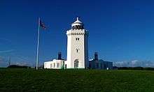 South Foreland Lighthouse from the front | |
 | |
| Location |
South Foreland Dover Kent England |
|---|---|
| Coordinates | 51°08′25″N 1°22′16″E / 51.14040°N 1.37110°ECoordinates: 51°08′25″N 1°22′16″E / 51.14040°N 1.37110°E |
| Year first constructed | 1793 (first) |
| Year first lit | 1843 (current) |
| Deactivated | 1988 |
| Construction | stone tower |
| Tower shape | octagonal tower with balcony and lantern attached to keeper's house |
| Markings / pattern | white tower and lantern |
| Height | 21 metres (69 ft) |
| Original lens | 1st order Fresnel lens |
| ARLHS number | ENG-087 |
| Heritage | National Trust owned |
South Foreland Lighthouse is a Victorian lighthouse on the South Foreland in St. Margaret's Bay, Dover, Kent, England, used to warn ships approaching the nearby Goodwin Sands. It went out of service in 1988 and is currently owned by the National Trust. Another lighthouse had previously stood on the site since at least 1730 and during most of this time it was manned by the Knott family of lighthouse keepers.
Firsts
South Foreland was the first lighthouse to use an electric light. This was in 1859. By 1875 the lighthouse was using carbon arc lamps powered by a steam-driven magneto.[1]
It was used by Guglielmo Marconi during his work on radio waves, receiving the first ship-to-shore message from the East Goodwin lightship. The system was used over the following winter to avert several shipwrecks. In 1899, the first international transmission was made between the lighthouse and Wimereux in France.[2]
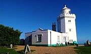 The lighthouse from the back
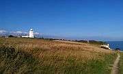 Approaching the lighthouse from the pathway from Dover
.JPG) South Foreland Lighthouse at a distance from the English Channel
South Foreland Lighthouse at a distance from the English Channel
Two lighthouses
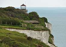
Originally, there was another lighthouse further down towards the cliff edge to give a bearing on the leading lights principle when a ship was at the point where it could safely turn left into the Downs behind the sands or right to go safely around the Sands. They were both built in the 1840s. However, the Sands shifted over the following years until this bearing became dangerously inaccurate and so the lower light was taken out of service in 1910. It still survives as part of a private garden but is under threat from cliff erosion.
The destruction of Trinity House records during the last war has prompted considerable conjecture about this lighthouse's history because other source material is hard to find. Whilst beacons or votive lights may have existed from early times one of the first reliable references is found the Penny Magazine 19th Sept. 1835, pp365, and states that Charles I granted letters-patent to 'continue and renew' the lighthouses at the North and South Forelands to Sir John Meldrum. Presumably, a record exists, somewhere of an earlier bequest.
It is a fact that two lighthouses still stand here, but it is by no means certain why they were built. The popular leading lights theory lacks conviction, since turning to port or starboard upon lining up the two lights would not automatically lead to safe passage unless the navigator knew precisely how far the ship was from land. A stronger argument seems to be that ships coming from the north might line up the lights in order to determine when it was safe to turn in for Dover Harbour. Seamen sailing up the channel might use these lights, not as leading lights (as popular opinion has it), but simply as lights in transit when another bearing is needed to confirm position. It is also uncertain why two lights were built in 1840 to give a lead when a Trinity House lightship had been stationed at the South Sands Head since 1832 precisely for that purpose. Lieutenant John Hay (British Channel Piloting, 1850) lists many bearings in the Downs using churches, buildings, mills, castles, and the upper South Foreland lighthouse, but makes no mention of one using both South Foreland lighthouses. Greg Holyoake, in his book Deal:All in the Downs, in a seemingly well-researched chapter on lighthouses and lightships (p. 100) says two lighthouses were first built at the South Foreland to distinguish it from the North Foreland. He also suggests the two lights served as a transit. Elsewhere,(vide) the authoritative and comprehensive website: www.pharology.eu says;"...since one light could be confused with another just along the coast it became necessary to make one light distinguishable from another. This was achieved by having two lights at the South Foreland whilst only one was shown at the North Foreland."
Movement of the Sands
.jpg)
Charts as far back as the 17th century show that the cyclic movement of the Sands was known. Although the chart of Robert Jager, 1629, (Shipwrecks of the Goodwin Sands, R & B Larne) may leave something to be desired in accuracy of the coastline, it seems to suggest that the South Sand Head was farther south than it was in the next century and that the Head was turning back upon itself in cyclic movement. Early in the eighteenth century the South Sand Head was still so far south that the chart of Charles Labelye,1736,(Public Records Office)shows a number of bearings, one of which runs through the two lighthouses then in existence and unmistakably strikes the Head. Richard Larne (Shipwrecks of the Goodwin Sands) estimates the increase/decrease at 4000 feet a century. It would seem to have been a foolish act to build two lighthouses to cover a bearing that so soon would be useless even if new sites were selected. Less widely known is the fact that a lightship of sorts is said to have been stationed at the South Sands Head since Elizabethan times for the express purpose of guiding the fleet into the anchorage of the Downs, although evidence for this assertion is slim. How effective a primitive light vessel may have been is a matter of speculation.
Multiple lights
We know, also, that multiple lights were a feature of many locations before occulting lights arrived to give a station clear identity at night. The Cornwall Tourist Board website says: "Trinity House built a two coal fired station (at the Lizard)... The signal continued as two fixed lights until 1903... in 1903 the two tower system was stopped and a single flashing light used."
The presence of two lights at the South Foreland distinguished it from its close neighbour at the North Foreland. A rotating mechanism, that presumably allowed the light to occult, was installed in 1904. Shortly afterwards (1910) the second lighthouse was taken out of service.
There is also a twin lighthouse at the North Foreland, on the coast at Broadstairs, and still in operation (though automated).
In popular culture
The South Foreland Lighthouse is one of the landmarks mentioned in the British sea shanty "Spanish Ladies".
The ChuckleVision episode "Finders Keepers" was filmed here.
The Doomwatch episode "The Red Sky" was filmed here.
See also
References
- ↑ Baird, Spencer Fullerton (1876). Annual record of science and industry. New York: Harper & Brothers. p. 460.
- ↑ Degna Marconi (1962). My Father Marconi. pp. 68–71.
External links
| Wikimedia Commons has media related to South Foreland Lighthouse. |