Wuntho
| Wuntho | |||||
| Outlying state of the Sagaing Division | |||||
| |||||
 | |||||
| History | |||||
| • | State founded | Before 1200 | |||
| • | State merged into Katha District | 1891 | |||
| Area | |||||
| • | (estimate) | 6,200 km2 (2,394 sq mi) | |||
| Population | |||||
| • | (estimate) | 150,000 | |||
| Density | 24.2 /km2 (62.7 /sq mi) | ||||
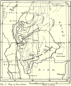
Wuntho (Burmese: ဝန်းသို) or Waing Hso (Shan: ဝဵင်းသိူဝ်) was a native state of Upper Burma when Burma (Myanmar), was under British control. It had an area of around 6,200 square kilometres (2,400 sq mi) with 150,000 inhabitants and lay midway between the Ayeyarwady River and Chindwin River.[1]
History
Wuntho state was founded before 1200. In 1885 the British annexed Upper Burma and established their rule in the region. Wuntho rebelled in 1891 but the British quelled the uprising.[2] As a consequence a force of 1,800 British soldiers under General Sir George Wolseley occupied the town of Wuntho. In 1892 the state was formally annexed by the British and incorporated into the District of Katha.[1] It was classed by the Burmese as a Shan state, but was never on the same footing as the Shan states to the east.
Rulers
The rulers of Wuntho bore the title Saopha.[3]
Saophas
- 1698 - 1703 Maung Sun
- 1703 - 1714 Kyaung Pyn
- 1714 - 1736 Myat Kaung
- 1736 - 1753 Vacant
- 1751 - 1756 Talaings
- 1756 - 1778 Aung Nyo
- 1778 - 1796 Maung Tin (d. 1796)
- 1796 - 1798 Maung Taw Zan (d. 1798)
- 1798 - 1827 Maung Tha Ywe (administrator to 1802)
- 1827 - 1830 Maung Shwe
- 1830 - 1833 Maung Pe Nge
- 1833 - 1849 Shwe Thi
- 1849 - 1851 San Tit
- 1852 - 1878 Mama Shwe Tha (d. af.1891) (from 1866, Mahawuntho Thohonbwa)
- 1878 - 7 Feb 1891 Maung Aung Myat (b. 1857 - d. af.1909)
References
- 1 2

- ↑ Imperial Gazetteer of India, v. 24, p. 399
- ↑ Shan and Karenni States of Burma
External links
- Satellite map of Wuntho Maplandia
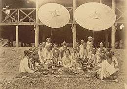
- The Wuntho Sawbwa's troops surrendering arms to the British authorities at Wuntho - photo University of Cambridge
Coordinates: 23°53′N 95°40′E / 23.883°N 95.667°E