Mongnai State
| Mongnai (Mone) | |||||
| State of the Shan States | |||||
| |||||
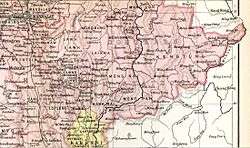 | |||||
| Capital | Mong Nai | ||||
| History | |||||
| • | State founded | bf. 1800 | |||
| • | Abdication of the last Saopha | 1959 | |||
| Area | |||||
| • | 1901 | 5,129 km2 (1,980 sq mi) | |||
| Population | |||||
| • | 1901 | 44,252 | |||
| Density | 8.6 /km2 (22.3 /sq mi) | ||||
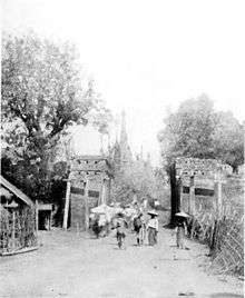
The Gate at Mongnai in a picture by Sir James George Scott.
Mongnai, also known as Möngnai, Mone, Mōng Nai or Monē,[1] was a Shan state in what is today Burma. It belonged to the Eastern Division of the Southern Shan States.[1] Its capital was Mongnai town.[2]
History
Möngnai state was founded before 1800. According to tradition a predecessor state named Saturambha had existed previously in the area.[3]
Mongnai included the substates of Kengtawng[1] and Kenghkam. The latter was annexed in 1882.
Rulers (title Myoza)
- c.1802 – 1848: Maung Shwe Paw
- 1848 – 1850: Maung Yit
- 1850 – 1851: U Po Ka
- 1852: U Shwe Kyu
Rulers (title Saopha)
Ritual style Kambawsa Rahta Mahawunthiri Pawara Thudamaraza.[4]
- 1852 – 1875: Hkun Nu Nom
- 1875 – 1882: Hkun Kyi (1st time) (1847–1914)
- 1882 – 1888: Twet Nga Lu (usurper) (d. 1888)
- 1888 – 1914: Hkun Kyi (2nd time) (s.a.)
- 1914 – 1928: Hkun Kyaw Sam
- 1928 – 1949: Hkun Kyaw Ho (d. 1949)
- 1949 – 1958: Sao Pye
References
- 1 2 3

- ↑ Imperial Gazetteer of India, v. 17, p. 405.
- ↑ Ben Cahoon (2000). "World Statesmen.org: Shan and Karenni States of Burma". Retrieved 21 December 2010.
- ↑ "WHKMLA : History of the Shan States". 18 May 2010. Retrieved 21 December 2010.
External links
Coordinates: 20°31′N 97°52′E / 20.517°N 97.867°E
This article is issued from
Wikipedia.
The text is licensed under Creative Commons - Attribution - Sharealike.
Additional terms may apply for the media files.