Kenghkam
| Kenghkam State | |||||
| State of the Shan States | |||||
| |||||
 | |||||
| Capital | Keng Hkam | ||||
| History | |||||
| • | State founded | 1811 | |||
| • | Annexed by Mongnai State | 1882 | |||
| Area | |||||
| • | 1901 | 432.5 km2 (167 sq mi) | |||
| Population | |||||
| • | 1901 | 5,458 | |||
| Density | 12.6 /km2 (32.7 /sq mi) | ||||
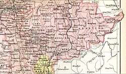
Kenghkam or Keng Hkam (also known as Kyaingkan) was a Shan state in what is today Burma. The capital was the town of Keng Hkam, located by the Nam Pang River.[1]
History
Kenghkam was initially a tributary of the Konbaung dynasty. It was founded in 1811 and was located north of the sub-state of Kengtawng. The state was occupied by Mongnai State from 1870 to 1874 and again from 1878 to 1882, when it was annexed directly.[2]
Rulers
The rulers of the state bore the title Myoza.[3]
- 1811 - 1854 Bodaw Sao Hkam Yi
- 1855 - 1864 Sao Hkun Mwe
- 1864 - 1870 Naw Hkam Leng
- 1870 - 1870 incorporated into Möngnai
- 1874 - 1878 Sao Hkun Long
- 1878 - 1882 incorporated into Möngnai
- 1882 - c.1889 Sao Naw Süng
- c.1889 - 1905 Hkun Un (b. 18.. - d. 1905)
- 1905 - 19.. Hkun Nawng Hkam (b. 1891 - d. 19..)
- 1905 - 1914? Sao Nang Tid Hti La (f) -Regent
See also
References
- ↑ Imperial Gazetteer of India, v. 15, p. 200.
- ↑ "WHKMLA : History of the Shan States". 18 May 2010. Retrieved 21 December 2010.
- ↑ Ben Cahoon (2000). "World Statesmen.org: Shan and Karenni States of Burma". Retrieved 21 December 2010.
Capital: Mong Kung | |
|
Coordinates: 21°52′0″N 97°22′0″E / 21.86667°N 97.36667°E
This article is issued from
Wikipedia.
The text is licensed under Creative Commons - Attribution - Sharealike.
Additional terms may apply for the media files.