Lawksawk State
| Lawksawk (Yatsawk) | |||||
| State of the Shan States | |||||
| |||||
 | |||||
| Capital | Lawksawk | ||||
| History | |||||
| • | State founded | 1630 | |||
| • | Abdication of the last Saopha | 1959 | |||
| Area | |||||
| • | 1901 | 3,537 km2 (1,366 sq mi) | |||
| Population | |||||
| • | 1901 | 24,839 | |||
| Density | 7 /km2 (18.2 /sq mi) | ||||
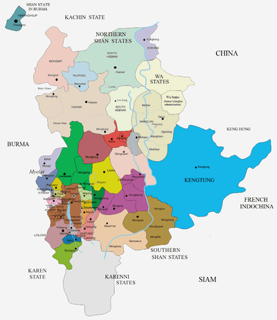
Lawksawk (Yatsawk)[1] was a Shan state in what is today Burma.[2] It was located north of Myelat and belonged to the Central Division of the Southern Shan States. Its capital was Lawksawk town. The state included 397 villages and the population was mostly Shan, but there were also Danu, Pa-O and Palaung people in the area.[3]
History
Lawksawk State was founded in 1630. According to tradition a predecessor state named Rathawadi had existed previously in the area. Between 1881 and 1886 the state was attacked and occupied by Yawnghwe.[4]
Lawksawk included the substate of Mongping (Möngping), located in the southeastern part and separated from Lawksawk State proper by the Nam Et River.[3]
Rulers (title Saopha)
Ritual style Kambawsa Rahta Maha Thiriwuntha Thudama.[5]
- 1680 - 1707 Pai Hkam
- 1707 - 1729 Shwe Gyaw
- 1729 - 1753 Hkun Shwe Tha
- 1753 - Jul 1760 Tha Pun Minaung
- 1760 - 1763 Maung Gyi
- 1763 - Jul 1790 Shwe Yi
- Jul 1790 - 1791 Vacant
- 1791 - 1792 Maung Kywet (d. 1792)
- 1791 - 1811 Hkun Sam Lik
- 1811 - 1812 Vacant
- May 1812 - 1813 On Gaing (d. 1834)
- 1813 - 1850 Hkun Shwe Ek (d. 1850)
- 1850 - Dec 1854 Vacant
- 1854 - 1856 Lai Hka (d. 1856)
- 1856 - 1881 Sao Waing (1st time) (b. 1846 - d. 1896)
- 1881 - 1886 Sai Pwin -Regent
- 1886 - Jan 1887 Sao Waing (2nd time) (s.a.)
- Jan 1887 - Oct 1887 Bo Saing -Regent
- 9 Oct 1887 - 1900 Hkun Nu (b. 18.. - d. 1900)
- 1900 - 1946 Sao Hkun Nsok (b. 1863 - d. 1946)
- 1946 - 1952 Sao Hkun So
References
- ↑ Lawksawk (Shan Princely State)
- ↑ "WHKMLA : History of the Shan States". 18 May 2010. Retrieved 21 December 2010.
- 1 2 Imperial Gazetteer of India, v. 16, p. 157.
- ↑ Ben Cahoon (2000). "World Statesmen.org: Shan and Karenni States of Burma". Retrieved 21 December 2010.
- ↑ "WHKMLA : History of the Shan States". 18 May 2010. Retrieved 21 December 2010.
External links
Coordinates: 21°14′N 96°52′E / 21.233°N 96.867°E