Wildenfels
| Wildenfels | ||
|---|---|---|
| ||
 Wildenfels Location of Wildenfels within Zwickau district 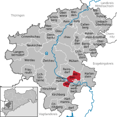  | ||
| Coordinates: 50°39′27″N 12°34′58″E / 50.65750°N 12.58278°ECoordinates: 50°39′27″N 12°34′58″E / 50.65750°N 12.58278°E | ||
| Country | Germany | |
| State | Saxony | |
| District | Zwickau | |
| Government | ||
| • Mayor | Tino Kögler | |
| Area | ||
| • Total | 20.57 km2 (7.94 sq mi) | |
| Elevation | 353 m (1,158 ft) | |
| Population (2017-12-31)[1] | ||
| • Total | 3,647 | |
| • Density | 180/km2 (460/sq mi) | |
| Time zone | CET/CEST (UTC+1/+2) | |
| Postal codes | 08134 | |
| Dialling codes | 037603 | |
| Vehicle registration | Z | |
| Website | www.wildenfels.de | |

Wildenfels is a municipality in Germany, Landkreis Zwickau in the Free State of Saxony. It is situated 9 km southeast of Zwickau.
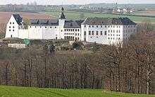
Wildenfels Castle
The construction of Wildenfels castle was begun before 1200 by the lords of Wildenfels. Between 1440 and 1706 it was a fief with Imperial immediacy. In 1602 it passed to the House of Solms which established the branch of Solms-Wildenfels. The counts of Solms-Wildenfels resided there until communist expropriation in 1945. Presently the castle is used for weddings and other events, partially for housing, the courtyards are accessible.
References
- ↑ "Aktuelle Einwohnerzahlen nach Gemeinden 2017] (Einwohnerzahlen auf Grundlage des Zensus 2011)" (PDF). Statistisches Landesamt des Freistaates Sachsen (in German). October 2018.
This article is issued from
Wikipedia.
The text is licensed under Creative Commons - Attribution - Sharealike.
Additional terms may apply for the media files.