Fraureuth
| Fraureuth | ||
|---|---|---|
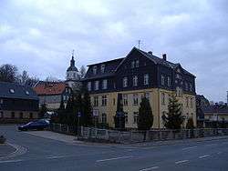 School house Fraureuth | ||
| ||
 Fraureuth Location of Fraureuth within Zwickau district 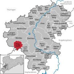  | ||
| Coordinates: 50°42′N 12°21′E / 50.700°N 12.350°ECoordinates: 50°42′N 12°21′E / 50.700°N 12.350°E | ||
| Country | Germany | |
| State | Saxony | |
| District | Zwickau | |
| Government | ||
| • Mayor | Matthias Topitsch (CDU) | |
| Area | ||
| • Total | 22.59 km2 (8.72 sq mi) | |
| Elevation | 330 m (1,080 ft) | |
| Population (2017-12-31)[1] | ||
| • Total | 5,204 | |
| • Density | 230/km2 (600/sq mi) | |
| Time zone | CET/CEST (UTC+1/+2) | |
| Postal codes | 08427 | |
| Dialling codes | 03761 | |
| Vehicle registration | Z | |
| Website | www.fraureuth.de | |

Fraureuth, located in the district of Zwickau, is a small town in Saxony, Germany. It has a population of around 5,834 inhabitants on a surface of 22,59 km². Fraureuth was a component of Thuringia until 1952.
References
- ↑ "Aktuelle Einwohnerzahlen nach Gemeinden 2017] (Einwohnerzahlen auf Grundlage des Zensus 2011)" (PDF). Statistisches Landesamt des Freistaates Sachsen (in German). October 2018.
External links
![]()
- Official website

This article is issued from
Wikipedia.
The text is licensed under Creative Commons - Attribution - Sharealike.
Additional terms may apply for the media files.