Oberwiera
| Oberwiera | ||
|---|---|---|
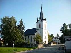 Church | ||
| ||
 Oberwiera Location of Oberwiera within Zwickau district 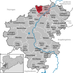  | ||
| Coordinates: 50°53′29″N 12°32′14″E / 50.89139°N 12.53722°ECoordinates: 50°53′29″N 12°32′14″E / 50.89139°N 12.53722°E | ||
| Country | Germany | |
| State | Saxony | |
| District | Zwickau | |
| Municipal assoc. | Waldenburg | |
| Government | ||
| • Mayor | Bernd Geringswald (CDU) | |
| Area | ||
| • Total | 14.33 km2 (5.53 sq mi) | |
| Elevation | 268 m (879 ft) | |
| Population (2017-12-31)[1] | ||
| • Total | 1,021 | |
| • Density | 71/km2 (180/sq mi) | |
| Time zone | CET/CEST (UTC+1/+2) | |
| Postal codes | 08396 | |
| Dialling codes | 037608 | |
| Vehicle registration | Z | |
| Website | www.gemeindeoberwiera.de | |

Oberwiera is a municipality in the district of Zwickau in Saxony in Germany. Oberwiera has the following districts: Harthau, Neukirchen, Niederwiera, Oberwiera, Röhrsdorf and Wickersdorf. Around half of the population lives in the main district of Oberwiera.
Municipalities around Oberwiere are Remse, Schönberg and the city of Waldenburg as well as Nobitz and Ziegelheim in Thuringia.
History
Oberwiera was mentioned the first time in 1254 a. D. Therefore Oberwiera is as old as its neighbor city Waldenburg.
References
- ↑ "Aktuelle Einwohnerzahlen nach Gemeinden 2017] (Einwohnerzahlen auf Grundlage des Zensus 2011)" (PDF). Statistisches Landesamt des Freistaates Sachsen (in German). October 2018.
This article is issued from
Wikipedia.
The text is licensed under Creative Commons - Attribution - Sharealike.
Additional terms may apply for the media files.