Lichtenstein, Saxony
| Lichtenstein | ||
|---|---|---|
.JPG) The rear façade of the palace in Lichtenstein. | ||
| ||
 Lichtenstein Location of Lichtenstein within Zwickau district 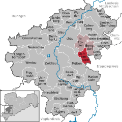  | ||
| Coordinates: 50°45′23″N 12°37′54″E / 50.75639°N 12.63167°ECoordinates: 50°45′23″N 12°37′54″E / 50.75639°N 12.63167°E | ||
| Country | Germany | |
| State | Saxony | |
| District | Zwickau | |
| Municipal assoc. | Rund um den Auersberg | |
| Government | ||
| • Mayor | Thomas Nordheim | |
| Area | ||
| • Total | 15.48 km2 (5.98 sq mi) | |
| Elevation | 336 m (1,102 ft) | |
| Population (2017-12-31)[1] | ||
| • Total | 11,481 | |
| • Density | 740/km2 (1,900/sq mi) | |
| Time zone | CET/CEST (UTC+1/+2) | |
| Postal codes | 09350 | |
| Dialling codes | 037204 | |
| Vehicle registration | Z | |
| Website | www.lichtenstein-sachsen.de | |
.png)
Lichtenstein is a town in the Zwickau district, in Saxony, Germany. It is situated 11 km northeast of Zwickau, and 22 km southwest of Chemnitz. It was owned by the House of Schönburg from 1286 until 1945.
See also

.jpg)
.jpg)
.JPG)
The Old Castle at Lichtenstein
References
- ↑ "Aktuelle Einwohnerzahlen nach Gemeinden 2017] (Einwohnerzahlen auf Grundlage des Zensus 2011)" (PDF). Statistisches Landesamt des Freistaates Sachsen (in German). October 2018.
This article is issued from
Wikipedia.
The text is licensed under Creative Commons - Attribution - Sharealike.
Additional terms may apply for the media files.