Whitehouse Station, New Jersey
| Whitehouse Station, New Jersey | |
|---|---|
| Census-designated place | |
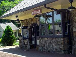 Whitehouse Train Station & Readington Library | |
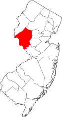
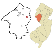 Map of Whitehouse Station highlighted within Hunterdon County. Right: Location of Hunterdon County in New Jersey. | |
| Coordinates: 40°36′58″N 74°46′19″W / 40.616169°N 74.771893°WCoordinates: 40°36′58″N 74°46′19″W / 40.616169°N 74.771893°W | |
| Country |
|
| State |
|
| County | Hunterdon |
| Township | Readington |
| Area[1] | |
| • Total | 1.346 sq mi (3.487 km2) |
| • Land | 1.303 sq mi (3.376 km2) |
| • Water | 0.043 sq mi (0.111 km2) 3.20% |
| Elevation[2] | 174 ft (53 m) |
| Population (2010 Census)[3] | |
| • Total | 2,089 |
| • Density | 1,602.7/sq mi (618.8/km2) |
| Time zone | UTC-5 (Eastern (EST)) |
| • Summer (DST) | UTC-4 (Eastern (EDT)) |
| ZIP code | 08889[4] |
| Area code(s) | 908 |
| FIPS code | 3480720[1][5] |
| GNIS feature ID | 02390505[1][6] |
Whitehouse Station is an unincorporated community and census-designated place (CDP) located within Readington Township, in Hunterdon County, New Jersey, United States.[7][8] At the 2010 United States Census, the CDP's population was 2,089.[3] Whitehouse Station takes its name from Whitehouse and Abraham Van Horne's 18th century tavern.[9]
New Jersey Transit offers service on the Raritan Valley Line at White House Station.[10]
History
The area, which is now served only by New Jersey Transit's Raritan Valley Line, used to be a railroad junction, serving as the endpoint of the ill-fated Rockaway Valley Railroad, which ceased operation in 1913.[11] Whitehouse Station was home to the global headquarters of pharmaceutical giant Merck, which was housed in the modernist Merck Headquarters Building. Merck is in the process of moving out of the campus, shifting its base of operations to Kenilworth.[12]
Geography

According to the United States Census Bureau, the CDP had a total area of 1.346 square miles (3.487 km2), including 1.303 square miles (3.376 km2) of land and 0.043 square miles (0.111 km2) of water (3.20%).[1][13]
Demographics
| Historical population | |||
|---|---|---|---|
| Census | Pop. | %± | |
| 1990 | 1,287 | — | |
| 2000 | 1,951 | 51.6% | |
| 2010 | 2,089 | 7.1% | |
| Population sources: 2000[14] 2010[3] | |||
Census 2010
As of the 2010 United States Census, there were 2,089 people, 963 households, and 552.8 families residing in the CDP. The population density was 1,602.7 per square mile (618.8/km2). There were 989 housing units at an average density of 758.8 per square mile (293.0/km2). The racial makeup of the CDP was 91.53% (1,912) White, 2.82% (59) Black or African American, 0.05% (1) Native American, 3.06% (64) Asian, 0.00% (0) Pacific Islander, 1.15% (24) from other races, and 1.39% (29) from two or more races. Hispanic or Latino of any race were 5.27% (110) of the population.[3]
There were 963 households out of which 23.2% had children under the age of 18 living with them, 46.0% were married couples living together, 8.9% had a female householder with no husband present, and 42.6% were non-families. 37.1% of all households were made up of individuals, and 17.1% had someone living alone who was 65 years of age or older. The average household size was 2.17 and the average family size was 2.87.[3]
In the CDP, the population was spread out with 19.6% under the age of 18, 4.3% from 18 to 24, 23.1% from 25 to 44, 31.5% from 45 to 64, and 21.4% who were 65 years of age or older. The median age was 46.6 years. For every 100 females there were 82.6 males. For every 100 females ages 18 and older there were 77.3 males.[3]
Census 2000
At the 2000 United States Census[5] there were 1,951 people, 878 households and 531 families residing in the CDP. The population density was 583.9/km2 (1,515.2/mi2). There were 905 housing units at an average density of 270.9/km2 (702.8/mi2). The racial makeup of the CDP was 96.05% White, 0.87% African American, 0.97% Asian, 0.56% from other races, and 1.54% from two or more races. Hispanic or Latino of any race were 2.56% of the population.[14]
There were 878 households of which 24.9% had children under the age of 18 living with them, 47.4% were married couples living together, 10.4% had a female householder with no husband present, and 39.5% were non-families. 34.1% of all households were made up of individuals and 11.3% had someone living alone who was 65 years of age or older. The average household size was 2.22 and the average family size was 2.86.[14]
Age distribution was 19.9% under the age of 18, 5.1% from 18 to 24, 33.5% from 25 to 44, 26.4% from 45 to 64, and 15.1% who were 65 years of age or older. The median age was 40 years. For every 100 females there were 87.4 males. For every 100 females age 18 and over, there were 79.7 males.[14]
The median household income was $75,111, and the median family income was $92,793. Males had a median income of $60,673 versus $43,438 for females. The per capita income for the CDP was $38,627. None of the families and 1.4% of the population were living below the poverty line, including no under eighteens and 2.9% of those over 64.[14]
Notable people
People who were born in, residents of, or otherwise closely associated with Whitehouse Station include:
- Taissa Farmiga (born 1994), actress.[15]
- Robyn Kenney (born 1979), field hockey player.[16]
- Tom Malloy (born 1974), actor and filmmaker.[17]
- Ed Martin, politician who served as Chair of the Missouri Republican Party.[18]
- James N. Pidcock (1836-1899), represented New Jersey's 4th congressional district in the United States House of Representatives from 1885 to 1889.[19]
References
- 1 2 3 4 Gazetteer of New Jersey Places, United States Census Bureau. Accessed July 21, 2016.
- ↑ U.S. Geological Survey Geographic Names Information System: White House Station Census Designated Place, Geographic Names Information System. Accessed November 20, 2012.
- 1 2 3 4 5 6 DP-1 - Profile of General Population and Housing Characteristics: 2010 Demographic Profile Data for White House Station CDP, New Jersey, United States Census Bureau. Accessed November 20, 2012.
- ↑ Look Up a ZIP Code for Whitehouse Station, NJ, United States Postal Service,. Accessed April 26, 2012.
- 1 2 American FactFinder, United States Census Bureau. Accessed September 4, 2014.
- ↑ US Board on Geographic Names, United States Geological Survey. Accessed September 4, 2014.
- ↑ New Jersey: 2010 - Population and Housing Unit Counts - 2010 Census of Population and Housing (CPH-2-32), United States Census Bureau, August 2012. Accessed November 15, 2012.
- ↑ Locality Search, State of New Jersey. Accessed April 19, 2015.
- ↑ Staff. "Living history in Whitehouse", Courier-News, March 6, 2005. Accessed November 16, 2012. "About 1750 Abraham Van Horne built the first tavern in the area. It was on the road from Clinton to Somerville where it crossed Rockaway Creek (now Route 22). Because the building had white plastered walls it became known as the 'White House'. The name also was given to the village which sprang up around the tavern."
- ↑ Hunterdon County Bus / Rail Connections, New Jersey Transit, backed up by the Internet Archive as of July 26, 2010. Accessed November 14, 2012.
- ↑ Wright, Terry. "Rockaway Valley Railroad memorabilia displayed by Tewksbury Historical Society", Hunterdon County Democrat, December 22, 2012. Accessed September 5, 2014.
- ↑ Merck (2012). "Merck to Move Global Headquarters Within New Jersey". Retrieved 2015-07-13.
- ↑ US Gazetteer files: 2010, 2000, and 1990, United States Census Bureau. Accessed September 4, 2014.
- 1 2 3 4 5 DP-1 - Profile of General Demographic Characteristics: 2000 from the Census 2000 Summary File 1 (SF 1) 100-Percent Data for White House Station CDP, New Jersey, United States Census Bureau. Accessed November 20, 2012.
- ↑ The Cast: Taissa Farmiga, Higher Ground (film), Sony Classics. Accessed April 26, 2012. "Named one of the breakout stars of the Sundance Film Festival in 2011 by The Daily Beast, Taissa Farmiga is, at sixteen years old, at the beginning of what promises to be an outstanding career.... Farmiga resides in Whitehouse Station, NJ."
- ↑ Robyn Kenney, USA Field Hockey. Accessed December 20, 2007.
- ↑ "Tom Malloy; A Prominent Figure in the Indie Film Scene", Talker of the Town, April 22, 2017. Accessed July 2, 2018. "I was born in Red Bank, NJ, and grew up in farm country NJ, in Hunterdon county in a little town called Whitehouse Station."
- ↑ Wagman, Jake. "Chris Christie hears it — from Ed Martin's mom", St. Louis Post Dispatch, October 6, 2011. Accessed July 9, 2018. "She questioned why Christie would support Wagner when 'Ed is a native born New Jerseyan,' the product of Readington Township Public Schools and St. Peter's Prep in Jersey City."
- ↑ James Nelson Pidcock, Biographical Directory of the United States Congress. Accessed September 3, 2007.