Westchester Square, Bronx
| Westchester Square | |
|---|---|
| Neighborhood of the Bronx | |
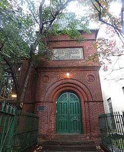 The front door to the historic Huntington Free Library on Lane Avenue | |
|
Location in New York City | |
| Coordinates: 40°50′35″N 73°50′35″W / 40.843°N 73.843°WCoordinates: 40°50′35″N 73°50′35″W / 40.843°N 73.843°W | |
| Country |
|
| State |
|
| City |
|
| Borough |
|
| Community District | Bronx 10[1] |
| Economics | |
| ZIP codes | 10461, 10462 |
| Area code | 718, 347, 929, and 917 |
| Website |
www |
Westchester Square is a residential neighborhood geographically located in the eastern section of the borough of The Bronx in New York City. The neighborhood is part of Bronx Community District 10. Its boundaries, starting from the north and moving clockwise are: East Tremont Avenue and Silver Street, Blondell Avenue and Westchester Creek to the east, Waterbury Avenue to the south and Castle Hill Avenue to the west. The main roadways into and out of Westchester Square are East Tremont Avenue, Westchester Avenue and Williamsbridge Road. ZIP codes include 10461 and 10462.[2] The area is patrolled by the 45th Precinct located at 2877 Barkley Avenue Bronx, New York 10465.
History
The village was founded about 1654 by English settlers who left New Haven Colony for Dutch New Netherland, on land purchased by Thomas Pell in 1654 from the sachem Ann-hock, alias Wampage, and other Native Americans,[3] although his right to do so was disputed by the Dutch who also laid claim to the land. The settlers followed the Westchester Creek to a path behind what is now Herbert H. Lehman High School to where the Square is now. The settlement was called Oostdorp, or East Towne, and called Westchester by the English settlers.
In a war in 1655 between the Dutch and Native Americans, the settlers of Oostdorp where suspected by the Dutch of working with the Esopus and Woppinger Indians and being instigators, so as to drive the Dutch from the area. In addition, they were in communication with the New Haven Colony, which drove Peter Stuyvesant to order their removal and the destruction of their homes in March 1656.[4] Twenty-three men were placed on board the ship de Waagh ("the Scales") and taken to New Amsterdam, where they were held prisoner on the ship Ballance. According to one account, they were "fed with rotten provision, creeping with worms, whereby some of them remained diseased to this day, after which they were carried away in chaines and laid in their dungeon at Manhatoes."[5] Shortly afterwards, the settlers agreed to submit to Dutch law and authority and were permitted to remain at Westchester. Thomas Wheeler, Thomas Newman, and John Lord were selected as the first magistrates. At that time, the town consisted of 25 men and 10-12 women.[6]
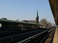
The village was the town seat of the Town of Westchester (the town hall being located at 40°50′34″N 73°50′40″W / 40.842753°N 73.844356°W[7]) until 1895, when that town became part of greater New York City. The Square is still laid out like a village, with the Owen Dolen Plaza, previously the village green, once again a central feature of the community. There are still many 19th-century homes throughout the neighborhood, including several old Victorian mansions. The Huntington Free Library and Reading Room is largely unchanged from its opening in the 1890s.[8] In 1920, the Interborough Rapid Transit Company's Pelham elevated line was opened with a stop at Westchester Square–East Tremont Avenue.[9]
The Westchester Square BID (business improvement district) was formally signed into law in March 2012. Led by business owner John Bonizio, the BID is funded by landlords and shopkeepers who pay a special property tax assessment to the city. It helps to patrol and promote the immediate shopping corridor.[10][11]
Arts and culture
- The Bronx Academy of Arts and Dance is located on the grounds of St. Peter's Episcopal Church in Westchester Square.[12]
Parks and recreation
- Owen Dolen Park is bordered by Westchester Avenue, Lane Avenue and Williamsbridge Road. It was recently renovated and rededicated in June 2013.[13][14] The $4.72 million renovation of the park was started in September 2011.[15] It was named after Owen Dolen a lifelong community resident and teacher, in 1926. Dolen had died of a heart attack a year earlier after giving a speech at the Square to unveil a granite memorial honoring neighborhood soldiers killed in World War I.[16]
- The name for the Pearly Gates Playground is derived from Christian tradition of the entranceway through which souls enter Heaven after death. The pearly gates are said to be guarded by Saint Peter, one of the founders of the Christian Church. The playground is named the Pearly Gates, because of its location on St. Peter’s Avenue. The playground originally opened in 1952 under the joint operation of Parks and the Board of Education. The park was originally called the Westchester Playground until 1998, when Parks Commissioner Henry Stern renamed the site The Pearly Gates.[17]
Transportation
The following New York City Subway stations serve Westchester Square:[18]
- East Tremont Avenue (6 and <6> trains)
- Zerega Avenue (6 and <6> trains)
The following MTA Regional Bus Operations bus routes serve Westchester Square:[19]
- Bx4, Bx4A: to Third Avenue–149th Street or Westchester Square (via Westchester Avenue; Bx4A also via East Tremont and Metropolitan Avenues)
- Bx8: to Williamsbridge or Throggs Neck (via Williamsbridge Road)
- Bx21: to Third Avenue–138th Street or Westchester Square (via Boston Road)
- Bx24: to Country Club or Hutchinson Metro Center
- Bx31: to Woodlawn or Westchester Square (via Eastchester Road)
- Bx40, Bx42: to Throggs Neck or Morris Heights (via Tremont Avenue)
References
- ↑ "NYC Planning | Community Profiles". communityprofiles.planning.nyc.gov. New York City Department of City Planning. Retrieved 25 February 2018.
- ↑ Haller, Vera (November 26, 2013). "Westchester Square, the Bronx: Stay Awhile". New York Times. Retrieved 2013-12-29.
- ↑ Robert Bolton. A History of the County of Westchester, from Its First Settlement, Volume II. New York: Alexander S. Gould, 1848
- ↑ Stephen Jenkins. The Story of The Bronx: From the Purchase Made by the Dutch from the Indian in 1639 to the Present Day. New York and London: G. P. Putnam’s Sons, The Knickerbocker Press. 1912.
- ↑ Edmund Bailey O'Callaghan MD, History of New Netherland. New York: Bartlett and Welford, D. Appleton and Company, 1849
- ↑ O'Callaghan, E.B. (1855). History of New Netherland: Or, New York Under the Dutch. Collection canadiana de Louis Melzack. D. Appleton & Company. pp. 312–316. Retrieved August 15, 2018.
- ↑ 1881 map of the Villages of Unionport and Westchester (David Rumsey Map Collection)
- ↑ Wu, Winnie (November 23, 2014). "Bronx Library May Get a New Neighbor: Another Library". New York Times. Retrieved 2014-11-29.
- ↑ "Subway Extension Opens Sunday". The New York Times. October 22, 1920. ISSN 0362-4331. Retrieved December 14, 2016.
- ↑ Beekman, Daniel (March 8, 2012). "Mayor Bloomberg signs Westchester Square Business Improvement District into law". New York Daily News. Retrieved 2016-09-28.
- ↑ Walsh, Robert (September 26, 2016). "The Bottom line For Small Business". CBS News New York. Retrieved 2016-09-28.
- ↑ Hirsch, Joe (October 28, 2013). "Legendary dance group gone from BankNote". Retrieved 2016-06-05.
- ↑ "Owen Dolan Park reopens in Westchester Square". News 12 The Bronx. Retrieved 2014-01-02.
- ↑ Rocchio, Patrick (June 14, 2013). "Owen Dolen reopens amid fanfare". Bronx Times Reporter. Retrieved 2014-09-21.
- ↑ Rocchio, Patrick (September 30, 2011). "Owen Dolen Park groundbreaking on $5 million renovation". Bronx Times Reporter. Retrieved 2014-09-21.
- ↑ Armaghan, Sarah (September 15, 2011). "Westchester Square rehab begins with overhaul of Owen Dolen Park". New York Daily News. Retrieved 2014-01-03.
- ↑ "The Pearly Gates". New York City Department of Parks and Recreation. Retrieved 2014-01-03.
- ↑ "Subway Map" (PDF). Metropolitan Transportation Authority. January 18, 2018. Retrieved January 18, 2018.
- ↑ "Bronx Bus Map" (PDF). Metropolitan Transportation Authority. September 2017. Retrieved April 24, 2018.
External links
| Wikimedia Commons has media related to Westchester Square, Bronx. |
- East Bronx History Forum
- Huntington Free Library and Reading Room
- St. Peter's Episcopal Church
- Westchester Square Business Improvement District
- Westchester Square-Zerega Improvement Organization
| South Bronx |  | |
|---|---|---|
| West Bronx | ||
| East Bronx | ||
| Related areas |
| |