Wellington Parish, New Brunswick
| Wellington | |
|---|---|
| Parish | |
 Saint-Édouard-de-Kent | |
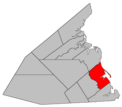 Location within Kent County, New Brunswick. | |
| Coordinates: 46°31′30″N 64°44′42″W / 46.525°N 64.745°W | |
| Country |
|
| Province |
|
| County | Kent County |
| Established | 1814 |
| Area[1] | |
| • Land | 195.31 km2 (75.41 sq mi) |
| Population (2011)[1] | |
| • Total | 3,327 |
| • Density | 17.0/km2 (44/sq mi) |
| • Pop 2006-2011 |
|
| • Dwellings | 1,915 |
| Time zone | UTC-4 (AST) |
| • Summer (DST) | UTC-3 (ADT) |
Wellington is a Canadian parish in Kent County, New Brunswick.[2]
Its population in the 2011 Census was 3,327.
Delineation
Wellington Parish is defined in the Territorial Division Act[3] as being bounded:
- South by Dundas Parish; north by Chockpish River and a line running south sixty-eight degrees west from the forks thereof; east by the Gulf of Saint Lawrence; and west by a line commencing where the southerly prolongation of the line between lots U and V, on the Little Buctouche River, strikes the northern boundary of Dundas Parish; thence along the prolongation of the said line north forty-three degrees west to the Little Buctouche River; thence down stream to the westerly line of lot number 7, granted to Joshua White; thence along the said westerly line of said lot to the northwest corner thereof; thence in a direct line to the southeast corner of lot number 13, granted to Michael Basterache, on the south side of the Buctouche River; thence along the eastern line of that lot northerly to the Buctouche River; thence to the mouth of Mill Creek; thence following the course of the said creek up stream to the eastern line of the grant to John W. Holderness, on said creek; thence northerly along that line to the rear line of said grant; thence westerly along said line to the western line of lots granted to Angus Cameron; thence northerly along that line and its prolongation to Mill Creek; thence following the various courses thereof up stream to the eastern line of lot number 101, granted to John McEachran; thence northerly along that line and its northern prolongation to the northern line of lot number 95, granted to John McNairn; thence westerly along the said last mentioned line and its western prolongation to meet the eastern line of lot number 138, granted to George Holder; thence along said eastern line and its prolongation in a northerly direction to the northern line of lot number 110 in Block O; thence along that line in an easterly direction to meet the southern prolongation of the eastern line of lot number 52, granted to John Cochrane; thence along said prolongation and eastern line of said last mentioned grant to the northern line of the parish, including the islands in front.
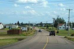
Communities
|
|
|
Demographics
See also
References
- 1 2 2011 Statistics Canada Census Profile: Wellington Parish, New Brunswick
- ↑ New Brunswick Provincial Archives - Wellington Parish
- ↑ "Territorial Division Act (R.S.N.B. 1973, c. T-3)". Government of New Brunswick website. Retrieved 30 August 2016.
- ↑ Statistics Canada: 1996, 2001, 2006 census
- ↑ 2006 Statistics Canada Community Profile: Wellington Parish, New Brunswick
Places adjacent to Wellington Parish, New Brunswick | ||||||||||
|---|---|---|---|---|---|---|---|---|---|---|
| ||||||||||
| Subdivisions | |
|---|---|
| Cities | |
| Counties | |
| |
Coordinates: 46°31′30″N 64°44′42″W / 46.52500°N 64.74500°W
This article is issued from
Wikipedia.
The text is licensed under Creative Commons - Attribution - Sharealike.
Additional terms may apply for the media files.