Welford, Northamptonshire
| Welford | |
|---|---|
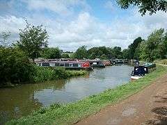 Welford Marina | |
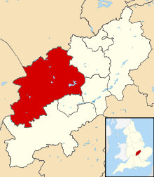
 Welford Welford shown within Northamptonshire | |
| Population | 1,043 (2011) |
| OS grid reference | SP6480 |
| District | |
| Shire county | |
| Region | |
| Country | England |
| Sovereign state | United Kingdom |
| Post town | Northampton |
| Postcode district | NN6 |
| Dialling code | 01858 |
| Police | Northamptonshire |
| Fire | Northamptonshire |
| Ambulance | East Midlands |
| EU Parliament | East Midlands |
| UK Parliament | |
Welford is a village and civil parish in England, on the River Avon border between Northamptonshire and Leicestershire. At the 2011 census, the population was 1,043.[1]
Location
It is on the main A5199 road connecting Northampton and Leicester and, being halfway between the two, was an important stagecoach stop. The A5199 is known as the 'Welford Road' for much of its length. It is close to the junction of the two major motor routes in England - the M1 motorway and the M6 motorway - and is 1½ miles north of Junction 1 of the A14, which connects that junction with the east of England.
History
In medieval times its Premonstratensian Abbey moved to Sulby some two miles to the east and Welford lost its market charter which was sold to West Haddon. There is clear evidence that Welford shrank considerably during the medieval period and it is notable that three of its neighbouring civil parishes — Elkington, Stanford-on-Avon and Sulby — are almost entirely depopulated.
A silver cup dating from the sixteenth century that was found in the village is in the British Museum.[2]
The history of the parish has been the subject of two books:
Notable buildings
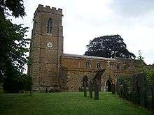
The Historic England website contains a total of 38 entries for listed buildings in the parish of Welford.[5] These are all Grade II, apart from St Mary's Church, which is Grade II*. They include:
- St Mary's Church, Church Lane
- The Talbot, High Street
- Manor House, West Street
- Welford Congregational Church, West End[6]
Facilities
It is served by a short arm from the Grand Union Canal and has two marinas. The Jurassic Way long distance footpath passes through the village on a SW/NE axis; although it officially makes its way through the fields to the east of the village, many walkers prefer to walk along the High Street to make use of the village's facilities.
Welford has a village shop and post office, a hairdresser, a primary school, a garage, a coffee & gift shop and two public houses.
Other amenities include a village hall, a sports field which is home to Welford Victoria F.C., a youth centre and a pocket park. There is also a spinney, which was a gravel quarry in the 19th century. To the North East of the village lie Welford Reservoir and Sulby Reservoir.
It is now administered as part of Daventry District having earlier been part of Oxendon Rural District (1894–1935) followed by Brixworth Rural District (1935–74).
References
- ↑ "Civil Parish population 2011". Neighbourhood Statistics. Office for National Statistics. Retrieved 12 July 2016.
- ↑ British Museum Collection
- ↑ Welford: Portrait of a Northamptonshire Village. Market Harborough: The Welford Village Appraisal Steering Group. 2000.
- ↑ Crowther, Barry, ed. (2001). Welford: The Legacy 1856 to 1980. Market Harborough: Matador.
- ↑ "Historic England – The List". Retrieved 2015-09-30.
- ↑ "Congregational Federation". Retrieved 2015-09-30.
External links
![]()
- The Official Welford Victoria Football Club Website
- The new site for the village
- Official Welford Brazilian Clothing Brand