Cold Ashby
| Cold Ashby | |
|---|---|
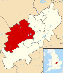
 Cold Ashby Cold Ashby shown within Northamptonshire | |
| Population | 278 (2011) |
| OS grid reference | SP6576 |
| District | |
| Shire county | |
| Region | |
| Country | England |
| Sovereign state | United Kingdom |
| Post town | Northampton |
| Postcode district | NN6 |
| Dialling code | 01604 |
| Police | Northamptonshire |
| Fire | Northamptonshire |
| Ambulance | East Midlands |
| EU Parliament | East Midlands |
| UK Parliament | |
Cold Ashby is a village and civil parish in the Daventry district of the county of Northamptonshire in England. At the time of the 2001 census, the parish's population was 255 people,[1] increasing to 278 at the 2011 census.[2]
Cold Ashby is surrounded by rolling farmland, and has a notable golf club. Its population is mainly commuters and their families, although farming is important to the local economy. The village has its own bowls and cricket clubs, and is within the catchment area of the Guilsborough schools. Lying on the 200 metres (656 ft) contour line Cold Ashby is said to be the highest village in Northamptonshire. The British Ordnance Survey's first trig point, the triangular post used by surveyors, was erected on 18 April 1936 near Cold Ashby. More than 11,000 of the posts were erected across Britain to enable surveyors to create maps accurate to within metres by measuring angles and using trigonometry to calculate distances between the pillars.[3]
References
- ↑ Office for National Statistics: Cold Ashby CP: Parish headcounts. Retrieved 8 November 2009
- ↑ "Civil Parish population 2011". Neighbourhood Statistics. Office for National Statistics. Retrieved 1 July 2016.
- ↑ "Mapping the history of Ordnance Survey's trig points". BBC News. 19 April 2011. Retrieved 25 August 2012.
External links
| Wikimedia Commons has media related to Cold Ashby. |
- The Official Website of the Parish of Cold Ashby
- Illustrated details
- Illustrated details of the parish church
- Map sources for Cold Ashby
- Cold Ashby's Independent Website