Hellidon
| Hellidon | |
|---|---|
 St John the Baptist parish church | |
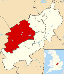
 Hellidon Hellidon shown within Northamptonshire | |
| Population | 256 (2011 Census)[1] |
| OS grid reference | SP5158 |
| District | |
| Shire county | |
| Region | |
| Country | England |
| Sovereign state | United Kingdom |
| Post town | Daventry |
| Postcode district | NN11 |
| Dialling code | 01327 |
| Police | Northamptonshire |
| Fire | Northamptonshire |
| Ambulance | East Midlands |
| EU Parliament | East Midlands |
| UK Parliament | |
| Website | Hellidon (Parish Meeting) |
Hellidon is a village and civil parish about 5 miles (8 km) southwest of Daventry in Northamptonshire, England. The parish has an area of about 1,600 acres (650 ha).[2] The village is between 520 feet (160 m) and 590 feet (180 m) above sea level on the north face of an ironstone ridge. Its highest point is 670 feet (200 m) above sea level, at Windmill Hill about 0.5 miles (800 m) southeast of the village. The Leam and a number of streams feeding it rise in the parish.
The 2011 Census recorded a parish population (including Lower and Upper Catesby) of 256.[1]
The Jurassic Way long distance footpath linking Banbury, Oxfordshire and Stamford, Lincolnshire passes through the village.
Manors
The Domesday Book of 1086 does not record Hellidon.[2] In the 12th century a manor of four hides at "Eliden" (Hellidon) was recorded as being of the fee of Berkhamsted.[3] From the 13th century Hellidon had two manors: Baskervilles and Giffords.[2] The present manor house at the northwest end of the village is on the site of the former Baskervilles Manor.[2] Giffords Manor was on the northeast side of the village, and there are substantial rectilinear earthworks where the house is said to have stood.[2] The house had been abandoned by the time of Hellidon's 18th-century land surveys.[2]
Church and chapel
Church of England
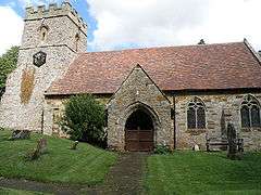
The Church of England parish church of St John the Baptist is Decorated Gothic[4] and hence either late 13th or early 14th century. The west tower survives in its medieval condition but in 1845–47 the nave and chancel were heavily restored for the Rev CS Holthouse under the direction of the Gothic Revival architect William Butterfield.[4] 20 years later Butterfield designed the north aisle and also the parish school, both of which were built in 1867.[4] In 1897 a north aisle was added to the chancel, designed by Matthew Houlding.[5] There is also a north transept. St John's is now a Grade II* listed building.[5]
The west tower has a ring of five bells. Hugh II Watts, who had foundries at Bedford and Leicester,[6] cast the fourth bell in 1615 and the second, third and tenor bells in 1635.[7] The Whitechapel Bell Foundry cast the treble bell in 1993.[7]
Nonconformist
Hellidon had a Nonconformist chapel in Berry Lane. The building is now a private house.
Economic and social history

Until the 1770s an open field system of farming prevailed in the parish. There were five open fields, and in 1726 they were mapped as Further Field, Lower Field, Middle Field, Upper Field and Short Attle Field.[2] In 1774 Parliament passed an enclosure act for Hellidon and in 1775 the parish was surveyed for enclosure.[2] On this map what had been Middle Field was marked as Hill Field and what had been Short Attle Field was simply Attle Field.[2]
On Windmill Hill a tower mill was built in the late 18th or early 19th century.[8] By 1973 it was derelict but since then the tower has been restored.[4] It is no longer a mill, but is an ancillary building for the Windmill Vineyard that has been planted around it.
A friendly society called the Institute was founded in Hellidon in 1805.[9] It still existed in 1905, when it celebrated its centenary.[9]
The earliest known record of a post office in Hellidon is from 1847. The first postmaster was John Wells,[10] who described himself as a shoemaker in the 1841 Census but as a shopkeeper in 1849. By 1854 he was described as "Postmaster and Letter Receiver".
The Grange is a house designed by William Butterfield and built for Rev C.S. Holthouse.[11] The core is a small older house that Holthouse bought, but Butterfield enlarged for him in 1850 and again in 1861.[11] It is a Grade II* listed building.[11]
Hellidon's highest recorded population was 449, in 1861.[12]
In August 1904 a fire in Cox's Lane destroyed three thatched cottages.[13]
Railways
The Great Central Main Line from the north of England to London Marylebone was built in the 1890s. It passed through the eastern edge of the parish in the 2,997-yard (2.7 km) Catesby Tunnel,[14] which was started in 1895 and completed in 1897. One of the tunnel's five air shafts is in Hellidon parish.
The line opened for goods traffic in 1898 and its nearest passenger station opened in March 1899 at Charwelton, about 2 miles (3 km) southeast of Hellidon village. British Railways closed the station in March 1963 and the line in September 1966.
From 1917 until 1961 the Park Gate Iron and Steel Company had a quarry about 0.5 miles (800 m) south of the village, on the southern boundary with Charwelton parish.[15] From there it ran a 1.5-mile (2 km) mineral railway down the Cherwell valley to take ironstone to the main line at Charwelton station.[16] A steam locomotive called Charwelton was built for the line in 1917, worked it until 1942, and is now preserved on the Kent and East Sussex Railway.[16]
Notable person
- George Harry Dury (1916–1996), geographer and hydrologist, was born at Hellidon.
Amenities
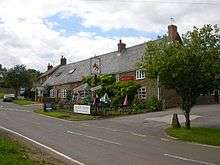
Hellidon has a public house, the Red Lion.
References
- 1 2 "Area: Hellidon (Parish); Key Figures for 2001 Census: Key Statistics". Neighbourhood Statistics. Office for National Statistics. Retrieved 30 October 2013.
- 1 2 3 4 5 6 7 8 9 RCHME 1981, pp. 102–103.
- ↑ Adkins & Serjeantson 1906, p. 270.
- 1 2 3 4 Pevsner & Cherry 1973, p. 252
- 1 2 Historic England (18 January 1968). "Church of St John the Baptist (1075284)". National Heritage List for England. Retrieved 30 October 2013.
- ↑ Dovemaster (31 October 2012). "Bell Founders". Dove's Guide for Church Bell Ringers. Central Council of Church Bell Ringers. Retrieved 30 October 2013.
- 1 2 Dawson, George (13 January 2012). "Hellidon S John Bapt". Dove's Guide for Church Bell Ringers. Central Council of Church Bell Ringers. Retrieved 30 October 2013.
- ↑ Historic England (24 February 1987). "The Windmill (1075291)". National Heritage List for England. Retrieved 30 October 2013.
- 1 2 Boyd-Hope, Sargent & Newton 2007, p. 89.
- ↑ Fell, 2000, & p. 111
- 1 2 3 Historic England (24 February 1987). "Church of St John the Baptist (1075290)". National Heritage List for England. Retrieved 30 October 2013.
- ↑ Fell, 2000
- ↑ Boyd-Hope, Sargent & Newton 2007, p. 85.
- ↑ "Railway Tunnel Lengths website, page 1". www.railwaycodes.org.uk. 28 January 1929. Retrieved 31 October 2013.
- ↑ "New Popular Edition Maps". Retrieved 31 October 2013.
- 1 2 "No. 14 Charwelton". Steam Locomotives. Kent and East Sussex Railway. Archived from the original on 29 October 2013. Retrieved 27 October 2013.
Sources
- Adkins, W.R.D.; Serjeantson, R.M., eds. (1902). A History of the County of Northampton. Victoria County History. 1. Westminster: Archibald Constable & Co. p. 370.
- Boyd-Hope, Gary; Sargent, Andrew; Newton, Sydney (2007). Railways and Rural Life: S W A Newton and the Great Central Railway. Swindon: English Heritage and Leicestershire County Council. pp. 85–89. ISBN 978-185074-959-2.
- Fell, Jenifer (2000). Three Ells in Hellidon. self-published. ISBN 0951565311.
- Pevsner, Nikolaus; Cherry, Bridget (revision) (1973) [1961]. Northamptonshire. The Buildings of England (2nd ed.). Harmondsworth: Penguin Books. p. 252. ISBN 0-14-071022-1.
- RCHME, ed. (1981). "Hellidon". An Inventory of the Historical Monuments in the County of Northamptonshire. 3 – Archaeological sites in North-West Northamptonshire. London: Royal Commission on the Historical Monuments of England. pp. 102–103.
External links
| Wikimedia Commons has media related to Hellidon. |
- Map sources for Hellidon