Weedon, Quebec
| Weedon | |
|---|---|
| Municipality | |
 | |
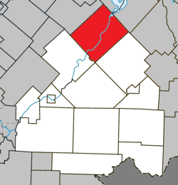 Location within Le Haut-Saint-François RCM. | |
 Weedon Location in southern Quebec. | |
| Coordinates: 45°42′N 71°28′W / 45.700°N 71.467°WCoordinates: 45°42′N 71°28′W / 45.700°N 71.467°W[1] | |
| Country |
|
| Province |
|
| Region | Estrie |
| RCM | Le Haut-Saint-François |
| Constituted | February 9, 2000 |
| Government[2] | |
| • Mayor | Jean-Claude Dumas |
| • Federal riding | Compton—Stanstead |
| • Prov. riding | Mégantic |
| Area[2][3] | |
| • Total | 225.00 km2 (86.87 sq mi) |
| • Land | 216.62 km2 (83.64 sq mi) |
| Population (2011)[3] | |
| • Total | 2,683 |
| • Density | 12.4/km2 (32/sq mi) |
| • Pop 2006-2011 |
|
| Time zone | UTC−5 (EST) |
| • Summer (DST) | UTC−4 (EDT) |
| Postal code(s) | J0B 3J0 |
| Area code(s) | 819 |
| Highways |
|
| Website |
www |
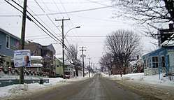
Weedon is a municipality of 2,683 people in Le Haut-Saint-François Regional County Municipality, in Quebec, Canada.[3]
On February 9, 2000, the village municipality of Saint-Gérard merged into Weedon.[4]
References
- ↑ Reference number 339510 of the Commission de toponymie du Québec (in French)
- 1 2 Geographic code 41098 in the official Répertoire des municipalités (in French)
- 1 2 3 "(Code 2441098) Census Profile". 2011 census. Statistics Canada. 2012.
- ↑ http://www.stat.gouv.qc.ca/publications/referenc/pdf/mod2000.pdf
External links

| Cities & Towns | |
|---|---|
| Municipalities | |
| Townships | |
| |
This article is issued from
Wikipedia.
The text is licensed under Creative Commons - Attribution - Sharealike.
Additional terms may apply for the media files.